

Friday Night Update
A very active weekend is ahead for Alabama… with two rounds of potentially severe storms ahead.
A new tornado watch is bring issued for parts of Southeast Louisiana and South Mississippi through the early morning hours, and very active storms continue to develop quickly over Louisiana.

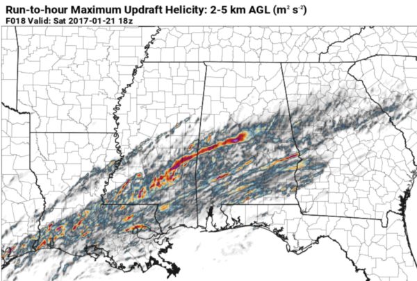
ROUND ONE: Severe storms will move into West and Southwest Alabama sometime in the 2-3 a.m. time frame… this is the forecast UH (updraft helicity) max through midday tomorrow, suggesting the highest tornado potential will be along and south of I-20…
In addition to the tornado threat, storms will be capable of producing hail and damaging winds. The main window for rain and storms will come from 3a CT until 9a CT; be sure you have a way of hearing severe weather warnings. A good app for this is WeatherRadio by WDT.
There will be a nice break from rain and storms from midday tomorrow through about midnight tomorrow night… the afternoon tomorrow should be pleasant with some sun at times and a high around 70 degrees.
ROUND TWO: We will have several waves of showers and storms from midnight tomorrow night through Sunday afternoon. With a generally unidirectional flow expected, the tornado risk is low; hail and gusty winds will be the main threat. It won’t rain all day Sunday, but a few passing showers and strong storms are likely.
Keep an eye on the blog for frequent updates through the weekend…
Category: Alabama's Weather
About the Author (Author Profile)
James Spann is one of the most recognized and trusted television meteorologists in the industry. He holds the AMS CCM designation and television seals from the AMS and NWA. He is a past winner of the Broadcast Meteorologist of the Year from both professional organizations.Subscribe
If you enjoyed this article, subscribe to receive more just like it.


