

A Calm Afternoon; More Severe Storms Tonight
After a very rough morning across Alabama, the storms have shifted into Georgia, an we expect a quiet afternoon with some sun breaking through the clouds and a high in the low 70s. But, another round of severe weather is likely late tonight and early tomorrow as a deep upper low approaches from the west.
ROUND TWO: The main window for strong to severe storms will come from roughly 11:00 tonight through 6:00 a.m. tomorrow.
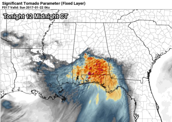
Highest tornado threat seems to be over the southern half of the state; STP (Significant Tornado Parameter) values are highest there, with a good combination of instability and shear.
But, understand the chance of a tornado over North Alabama is not zero, just much smaller. Storms tonight will also be capable of producing large hail and damaging straight line winds.
Additional rain amounts of 1-2 inches could also create some flooding issues.
CALL TO ACTION: Be sure you have a way of hearing severe weather watches and warnings. At home, you need a properly programmed NOAA Weather Radio with a battery backup. On your phone, for warnings we recommend WeatherRadio by WDT. You can watch our live severe weather coverage on the free ABC 33/40 app. Here are the links…
ABC 33/40 iOS version for iPhones and iPads
ABC 33/40 Android version for Android phones and tablets
Review your action plan in case a tornado warning polygon includes your home. Get in a small room, on the lowest floor, away from windows, and near the center of the house. You do NOT have to be underground. Never be in a car or mobile home.
Stay tuned to the blog for updates throughout the day…
Category: Alabama's Weather
About the Author (Author Profile)
James Spann is one of the most recognized and trusted television meteorologists in the industry. He holds the AMS CCM designation and television seals from the AMS and NWA. He is a past winner of the Broadcast Meteorologist of the Year from both professional organizations.Subscribe
If you enjoyed this article, subscribe to receive more just like it.


