

PDS Tornado Watch Issued for Southern 2/3rds of Alabama Until 3 a.m.
A tornado watch has been issued for is being considered right now for a large part of Central Alabama and South Alabama by the National Weather Service. It is a PDS or Particularly Dangerous Situation watch.
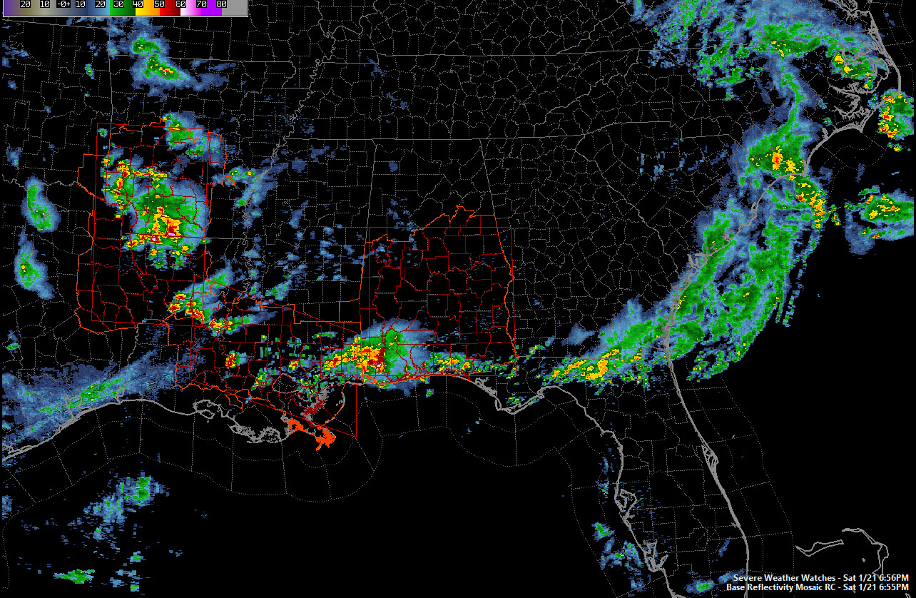
It goes until 3 a.m. CST. In Central Alabama, it includes: Autauga, Barbour, Bibb, Bullock, Chambers, Chilton, Clay, Coosa, Dallas, Elmore, Greene, Hale, Lee, Lowndes, Macon, Marengo, Montgomery, Perry, Pike, Randolph, Russell, Shelby, Sumter, Talladega and Tallapoosa Counties.
There is a high probability of tornadoes and a high probability of EF2 or greater tornadoes in the tornado watch area.
This is a serious situation and requires your full attention overnight if you live in the tornado watch area. Have a way to get warnings, stay abreast of the situation and know what your tornado plan is.
Storms have intensified rapidly in the past couple of hours over southeastern Louisiana and coastal Mississippi. They are spreading northeastward along a surge of warm, moist air from the Gulf of Mexico. There have been a few reports of large hail over southeastern Louisiana and Mississippi Coast.
Storms have also formed rapidly in Northwest Louisiana between Ruston and Alexandria. There have been several tornado warnings in that area. Lots of large hail reports here, including several 1.75-2 inch reports over NW Louisiana and southern Arkansas. Some really cold air aloft here is helping the hail to happen.
Tornado watches are already in effect from southeastern Oklahoma to the border of Mississippi and Alabama.
Thunderstorms are already over Mobile County should be deeper into Southwest Alabama by 8 p.m. There is already a tornado warning for Mobile County. They will spread quickly northeast into South Central Alabama, generally east of I-65 and south of I-85 by 10 pm. A couple of rounds may affect this same area into East Central Alabama between then and 2 a.m.
More storms will move into West Central Alabama by 10 pm. And will overspread areas north of I-59 through 4 a.m. Some of these storms will be severe as well, with large hail and damaging winds being the main threat but an isolated tornado is possible as well.
Category: Alabama's Weather, Severe Weather
About the Author (Author Profile)
Bill Murray is the President of The Weather Factory. He is the site's official weather historian and a weekend forecaster. He also anchors the site's severe weather coverage. Bill Murray is the proud holder of National Weather Association Digital Seal #0001 @wxhistorianSubscribe
If you enjoyed this article, subscribe to receive more just like it.


