

Severe Thunderstorm Warning Canceled For Parts Of Blount County
…THE SEVERE THUNDERSTORM WARNING FOR NORTHEASTERN BLOUNT COUNTY IS CANCELLED…
The storms which prompted the warning have moved out of the area.
Therefore the warning has been cancelled.
Severe Thunderstorm Warning Continues For Parts Of Blount County Until 215 AM CST
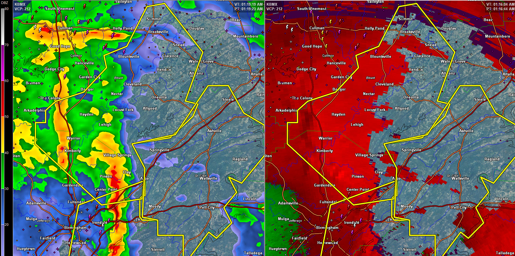
Jan 22nd @ 1:21 am
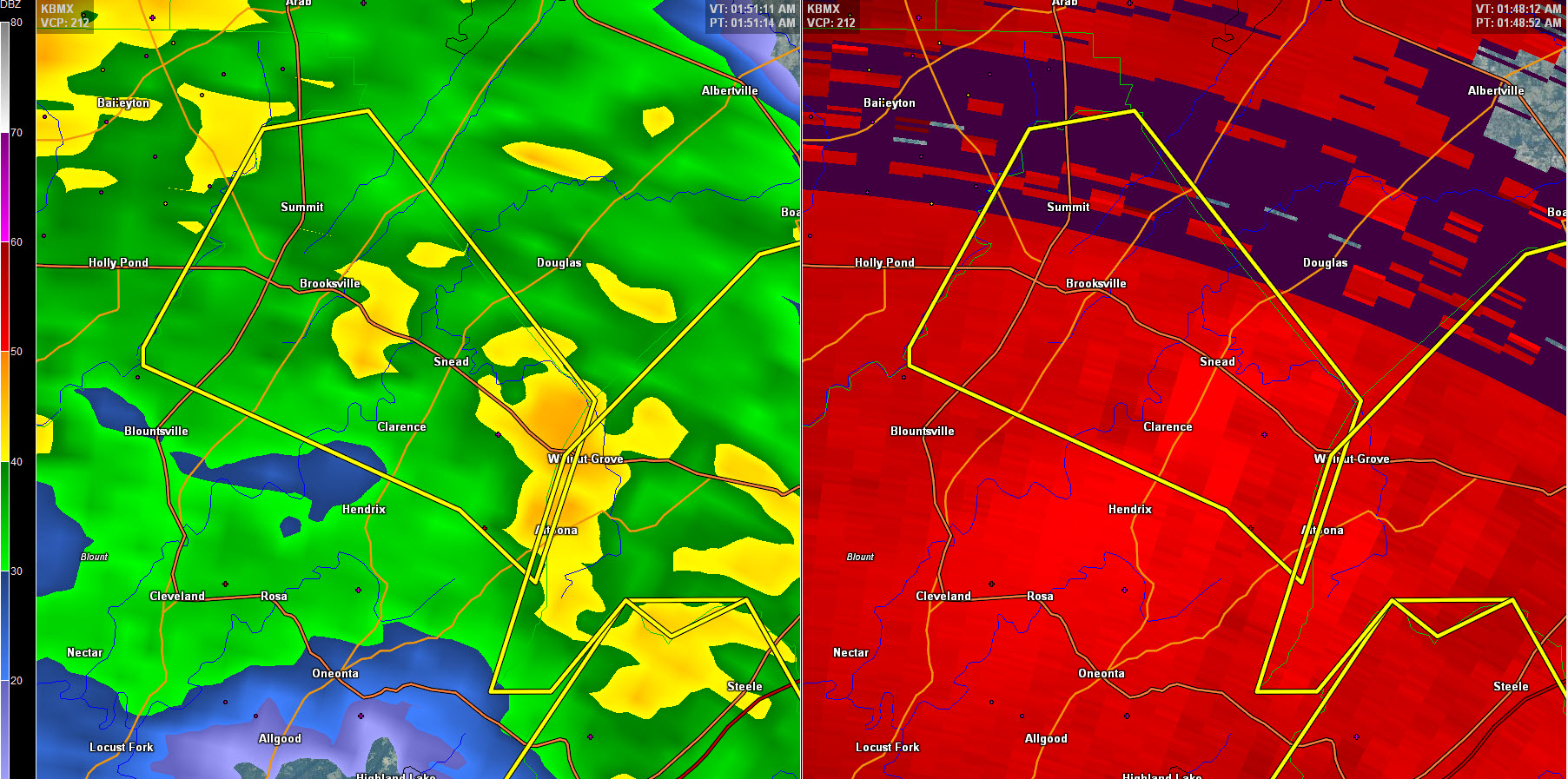
At 150 AM CST, severe thunderstorms were located along a line
extending from near Blountsville to near Snead to near Steele, moving
northeast at 50 mph.
HAZARD…60 mph wind gusts.
SOURCE…Radar indicated.
IMPACT…Expect damage to roofs, siding, and trees.
Locations impacted include…
Altoona, Snead, Susan Moore, Walnut Grove, Strawberry, McLarty and
Brooksville.
Severe Thunderstorm Warning Continues For Parts Of Blount County Until 215 AM CST
Jan 22nd @ 1:21 am
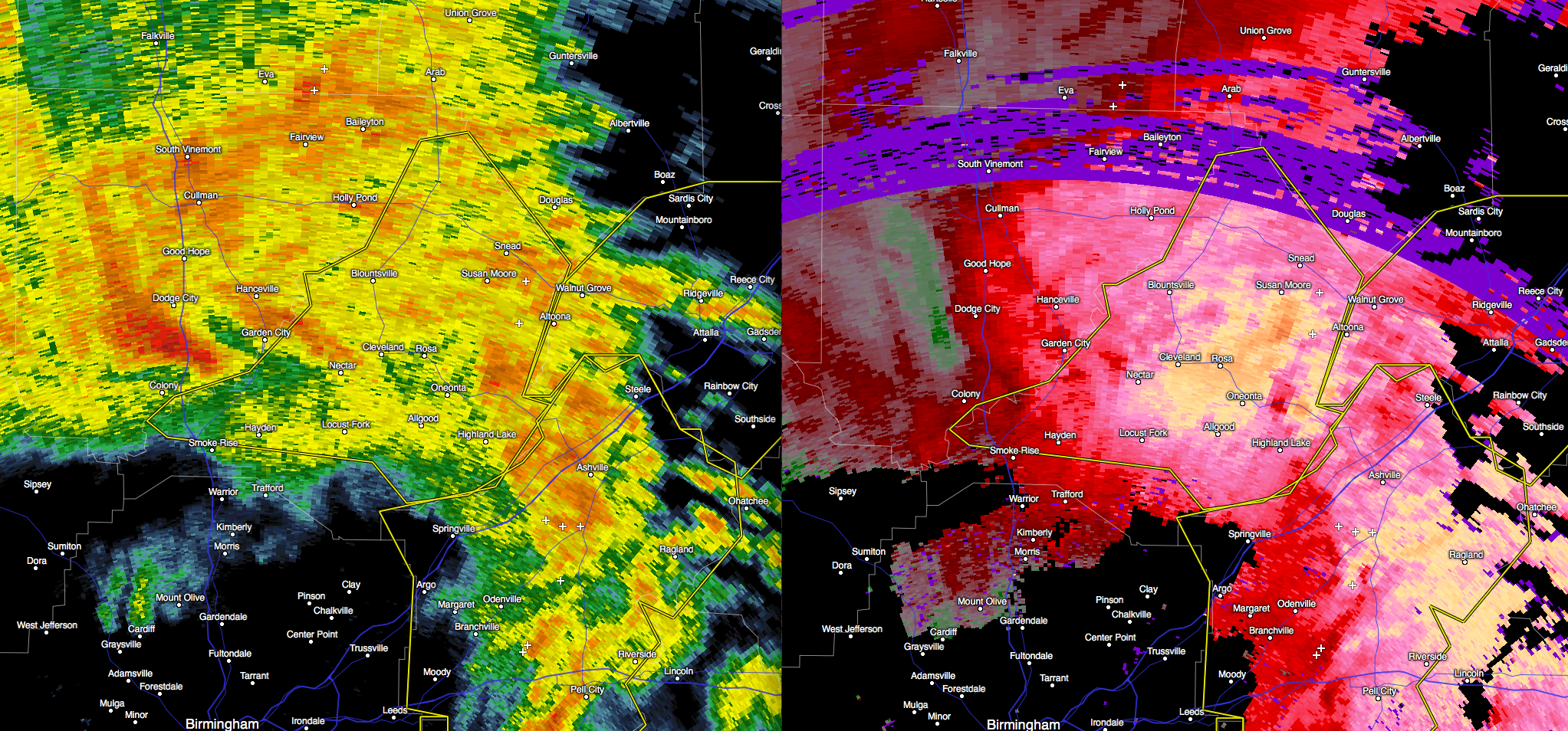
At 144 AM CST, severe thunderstorms were located along a line
extending from near Blountsville to Susan Moore to near Altoona,
moving northeast at 40 mph.
HAZARD…70 mph wind gusts.
SOURCE…Radar indicated.
IMPACT…Expect considerable tree damage. Damage is likely to mobile
homes, roofs, and outbuildings.
Locations impacted include…
Oneonta, Blountsville, Cleveland, Altoona, Snead, Susan Moore, Walnut
Grove, Rosa, Strawberry, McLarty, Brooksville, Chamblees Mill,
Hendrix and Fowler Spring.
Severe Thunderstorm Warning Continues For Parts Of Blount County Until 215 AM CST
Jan 22nd @ 1:21 am
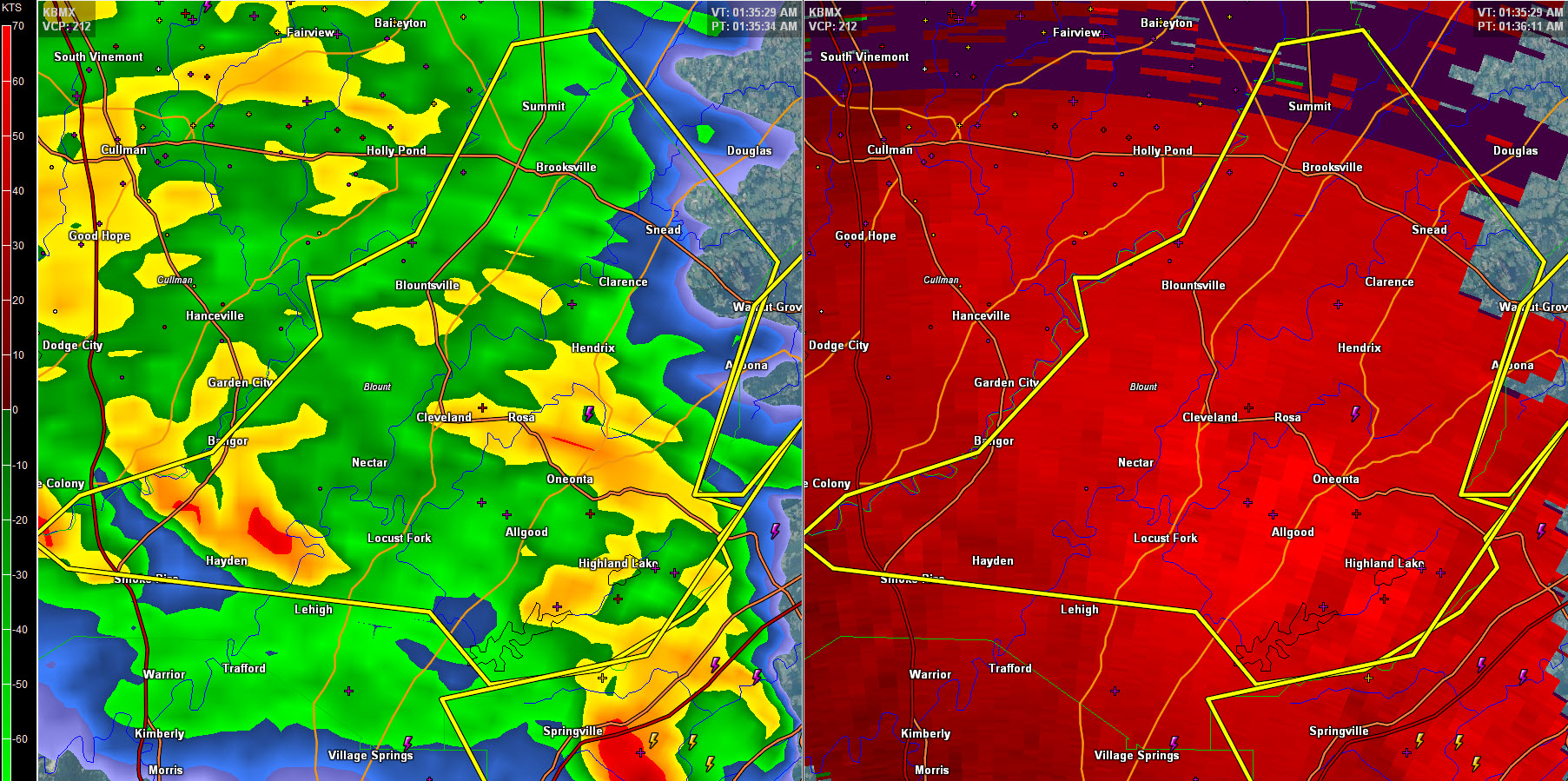
At 137 AM CST, severe thunderstorms were located along a line
extending from Bangor to Rosa to 6 miles northwest of Ashville,
moving northeast at 70 mph.
HAZARD…70 mph wind gusts.
SOURCE…Radar indicated.
IMPACT…Expect considerable tree damage. Damage is likely to mobile
homes, roofs, and outbuildings.
Locations impacted include…
Oneonta, Blountsville, Cleveland, Locust Fork, Altoona, Snead, Susan
Moore, Walnut Grove, Allgood, Fairview, Hayden, Nectar, Rosa, Inland
Lake, Blount Springs, Brooksville, Strawberry, Bangor, McLarty and
Highland Lake.
Severe Thunderstorm Warning Continues For Parts Of Blount County Until 215 AM CST
Jan 22nd @ 1:21 am
At 130 AM CST, severe thunderstorms were located along a line
extending from near Nectar to Allgood to near Springville, moving
northeast at 65 mph.
These are very dangerous storms.
HAZARD…80 mph wind gusts.
SOURCE…Radar indicated.
IMPACT…Flying debris will be dangerous to those caught without
shelter. Mobile homes will be heavily damaged. Expect
considerable damage to roofs, windows, and vehicles.
Extensive tree damage and power outages are likely.
Locations impacted include…
Oneonta, Blountsville, Cleveland, Dallas, Locust Fork, Altoona,
Snead, Susan Moore, Walnut Grove, Trafford, Allgood, Fairview,
Hayden, Nectar, Rosa, County Line, Inland Lake, Blount Springs,
Brooksville and Strawberry.
Severe Thunderstorm Warning Canceled For Parts Of Jefferson County
Jan 22nd @ 1:21 am
…THE SEVERE THUNDERSTORM WARNING FOR NORTHEASTERN JEFFERSON COUNTY IS CANCELLED…
The storms which prompted the warning have moved out of the warned
area. Therefore, the warning has been cancelled.
Severe Thunderstorm Warning Continues For Parts Of Blount And Jefferson Counties Until 215 AM CST
Jan 22nd @ 1:21 am
At 125 AM CST, severe thunderstorms were located along a line
extending from near Blount Springs to near Dallas to near Argo,
moving northeast at 60 mph.
These are very dangerous storms.
HAZARD…80 mph wind gusts.
SOURCE…Radar indicated.
IMPACT…Flying debris will be dangerous to those caught without
shelter. Mobile homes will be heavily damaged. Expect
considerable damage to roofs, windows, and vehicles.
Extensive tree damage and power outages are likely.
Locations impacted include…
Trussville, Oneonta, Blountsville, Cleveland, Dallas, Clay, Pinson,
Argo, Warrior, Kimberly, Locust Fork, Altoona, Snead, Susan Moore,
Walnut Grove, Trafford, Allgood, Fairview, Hayden and Nectar.
Severe Thunderstorm Warning Issued For Parts Of Blount And Jefferson Counties
Jan 22nd @ 1:21 am
Strong winds are impacting northern Jefferson County between Morris and Pinson. Winds may reach 75 mph.
The National Weather Service in Birmingham has issued a
* Severe Thunderstorm Warning for…
Blount County in Alabama…
Northeastern Jefferson County in Alabama…
* Until 215 AM CST
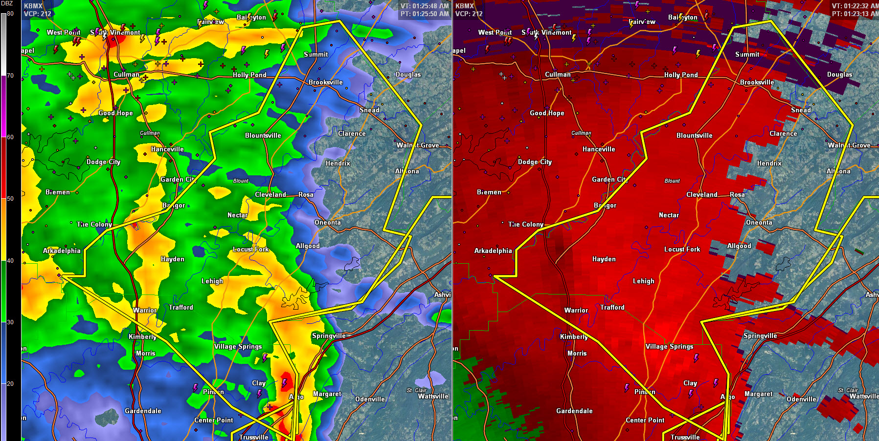
* At 118 AM CST, severe thunderstorms were located along a line
extending from near Arkadelphia to County Line to near Clay, moving
northeast at 55 mph.
HAZARD…70 mph wind gusts.
SOURCE…Radar indicated.
IMPACT…Expect considerable tree damage. Damage is likely to
mobile homes, roofs, and outbuildings.
* Locations impacted include…
Northeastern Birmingham, Trussville, Gardendale, Oneonta,
Blountsville, Cleveland, Dallas, Center Point, Clay, Pinson, Argo,
Warrior, Kimberly, Morris, Locust Fork, Altoona, Snead, Susan
Moore, Walnut Grove and Trafford.
Category: Current Warnings
About the Author (Author Profile)
Subscribe
If you enjoyed this article, subscribe to receive more just like it.


