

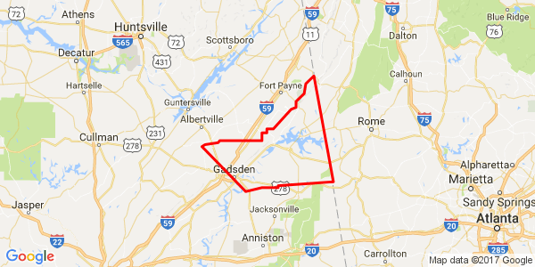
Flash Flood Warning Issued For Parts Of Cherokee And Etowah Counties
Heavy rain continues across North Alabama on the north side of the upper low, which is moving across South Central Alabama.
With the recent drought, it’s hard to imagine that we could be worried about flooding, but the steady rain all afternoon and last night are causing some problems.

The rain over Northwest Alabama should begin pivoting southeastward as the love moves eastward. This could pull it into the Birmingham area later.
The National Weather Service in Birmingham has issued a
* Flash Flood Warning for…
Cherokee County in northeastern Alabama…
Northeastern Etowah County in northeastern Alabama…
* Until 1045 PM CST
* At 749 PM CST, Doppler radar indicated heavy rain across the
warned area. More than three inches of rain has already fallen in
the past 6 hours. An additional one to two inches of rain can be
expected.
* Some locations that will experience flooding include…
Gadsden, Hokes Bluff, Centre, Cedar Bluff, Forney, Little River
Canyon National Preserve, Centre Municipal Airport, Glencoe, Sardis
City, Leesburg, Reece City, Sand Rock, Gaylesville, Tabor Road,
Pleasant Gap, Noccalula Falls, Ballplay, Slackland, Western Weiss
Lake and Moshat.
Category: Current Warnings
About the Author (Author Profile)
Subscribe
If you enjoyed this article, subscribe to receive more just like it.


