

Colder Air Returns Tomorrow/Friday
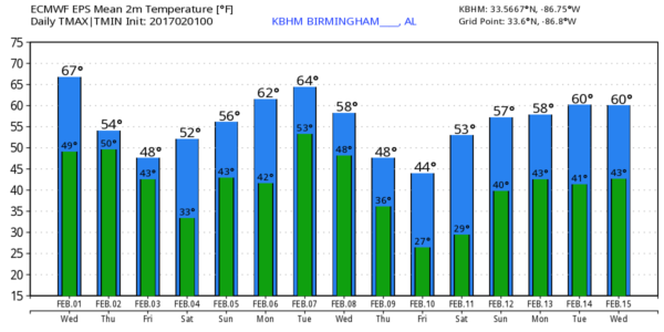
CALM MORNING: Another huge temperature spread across North/Central Alabama early this morning; at 5:00 we were seeing a 20 degree swing from 34 degrees at Fort Payne, to 54 at Birmingham. The sky is mostly fair, but clouds will increase today with a cold front approaching from the north. The weather remains very mild; today’s high should be in the upper 60s, not as warm as yesterday, but still above average for the first day of February. A few widely scattered showers are possible late this afternoon and tonight with the front, but rain amounts will be very light, and very spotty.
TOMORROW/FRIDAY: The surface front will drift down through the state, bringing cooler air and the chance of scattered light rain both days. Rain amounts will remain very light, generally under a quarter of an inch. The high tomorrow will be in the 52-55 degree range, and there is a pretty good chance we won’t get out of the 40s Friday. Quite the difference from yesterday’s warmth.
THE ALABAMA WEEKEND: Saturday continues to look cool and dry. We start the day in the 30s, the high will be in the 50s, and the sky will be partly sunny. Clouds return Sunday, and we will mention a chance of some rain during the day, but this wave looks rather unimpressive so rain amounts once again should stay on the light side. Looks like Sunday’s high will stay in the 50s.
NEXT WEEK: Monday for now looks mostly cloudy but generally dry with only a small risk of a shower; temperatures edge back up into the 60s. Next chance of rain comes Tuesday night and Wednesday with an approaching upper trough and surface front; this could bring 1/2 inch of rain with some thunder, but for now severe weather looks very unlikely. Much colder air invades the state toward the end of the week; some North Alabama communities could hold in the 30s all day Friday (February 10). See the Weather Xtreme video for maps, graphics, and more details.
WELCOME TO FEBRUARY: The average high/low for Birmingham will rise from 55/33 today… to 62/39 by the end of the month. Coldest temperature on record for the month at Birmingham is -10F, recorded on February 13, 1899… warmest is 83, measured on February 8, 1918, February 13, 1962, and February 23, 1996. The average rain for the month is 4.38″.
As always, watch me for the full weather story on ABC 33/40 News this evening at 4, 5, 6, and 10:00!
WEATHER BRAINS: Don’t forget you can listen to our weekly 90 minute netcast anytime on the web, or on iTunes. This is the show all about weather featuring many familiar voices, including our meteorologists here at ABC 33/40.
CONNECT: You can find me on all of the major social networks…
Facebook
Twitter
Google Plus
Instagram
Pinterest
Snapchat: spannwx
I will be doing a weather program today for patients at Children’s of Alabama… look for the next Weather Xtreme video here by 4:00 this afternoon. Enjoy the day!
Category: Alabama's Weather
About the Author (Author Profile)
James Spann is one of the most recognized and trusted television meteorologists in the industry. He holds the AMS CCM designation and television seals from the AMS and NWA. He is a past winner of the Broadcast Meteorologist of the Year from both professional organizations.Subscribe
If you enjoyed this article, subscribe to receive more just like it.


