

Wet and Cool for Your Sunday
First, let’s celebrate National Weatherperson’s Day for 2017! Hope you didn’t forget to get your favorite weatherperson a nice gift or at least a card!
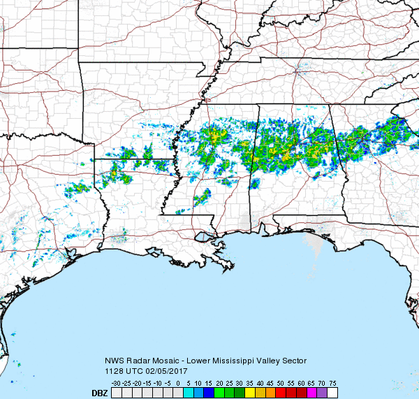
In the Southeast US it is going to be a cool and somewhat wet National Weatherperson’s Day. Light rain and showers are a bit more prevalent than I thought they would be, but the area can still use the rain to continue to reduce the drought conditions and eliminate any trace of the “extreme” conditions in Central Alabama. Along with the light rain it will remain cool with highs mainly in the lower 50s.
For those heading to the beach, a mix of sun and clouds can be expected through Thursday with chances for rain on Tuesday and Wednesday. Highs will be in the 60s to lower 70s with the exception of Thursday, when highs drop back into the 50s. See the complete Gulf Coast 7 Day Planner here.
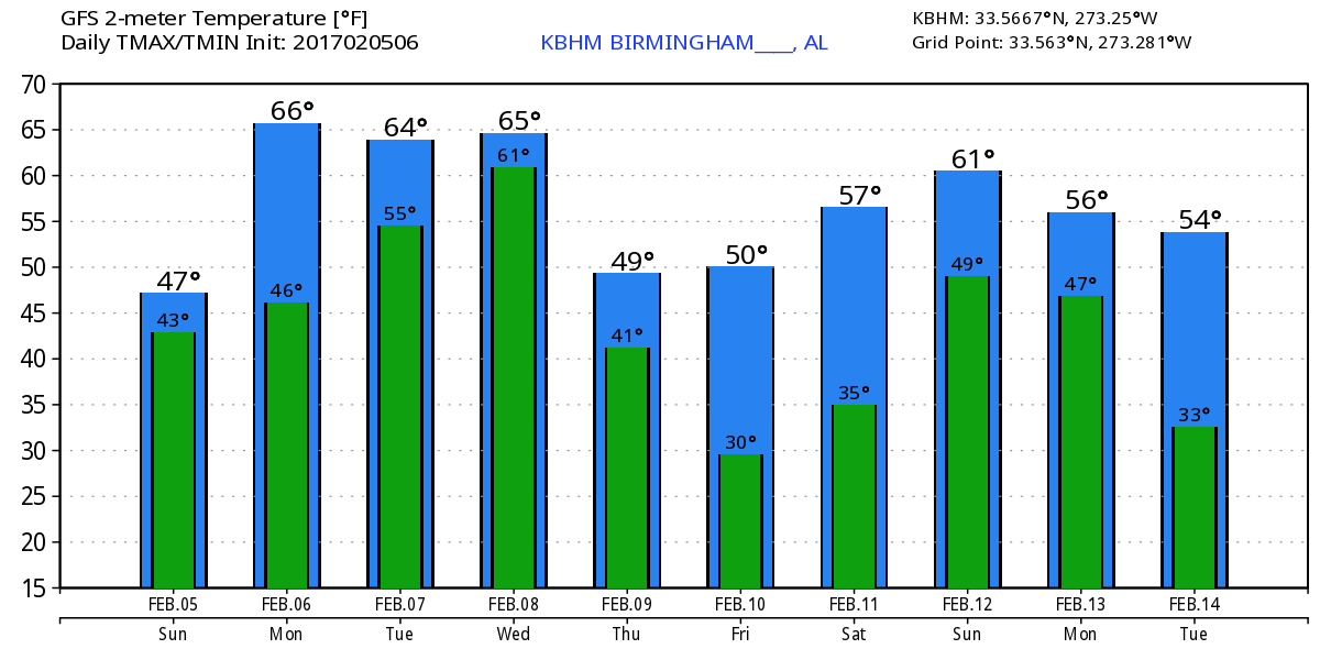
Monday will take on a close resemblance to today with light rain and showers likely during the first half of the day. But there will be a substantial difference in temperatures with highs climbing into the middle 60s thanks in part to the continued southerly flow and weak ridging aloft.
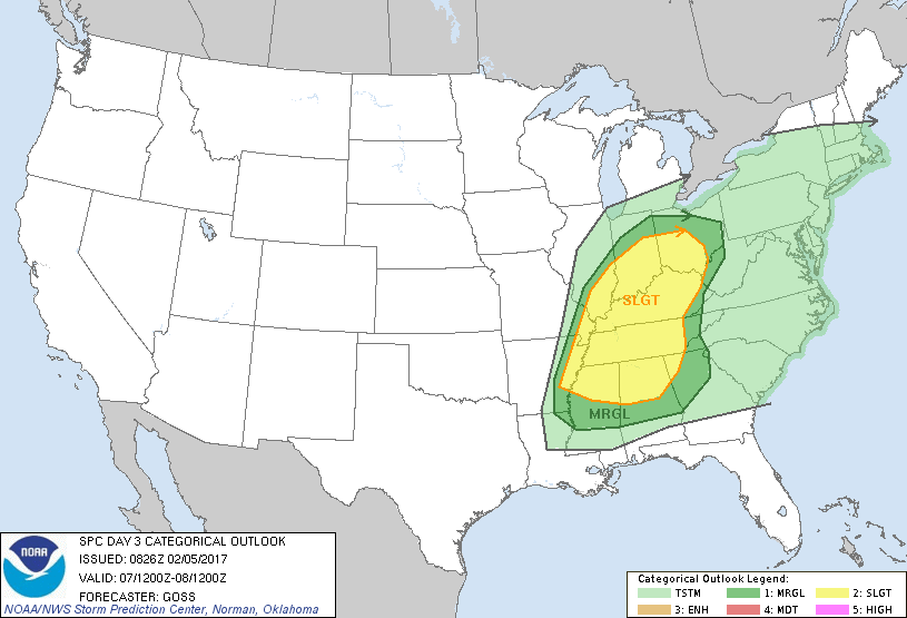
Monday we turn our attention to the trough coming into the Northwest US. This fast moving system will impact the Southeast US on Tuesday. At the surface, a surface low in the northern Rockies will develop and move quickly into the southern Great Lakes. This brings a cold front across the Central US into the Lower Mississippi River Valley on Tuesday. CAPE values Tuesday afternoon are projected to be in the 1200 to 1600 j/kg range along with sufficient shear values to support a slight risk for severe weather Tuesday afternoon into Tuesday evening. There are still some factors that do not yet align well such as a lack of strong destabilization during the afternoon. The ECMWF and the GFS are in fairly close agreement on the positions of the surface low and the front, but they still have some differences. So the development of this system will need careful watching in future models runs.
Wednesday the development of a trough over the eastern US gets underway. There is potential for another round of storms with a fast moving short wave embedded in the upper flow, however, moisture levels are forecast to be down, so this development is still somewhat iffy. The troughiness over the eastern US can really be seen by Thursday and continues into Friday. Friday morning could be our chilliest for the week as low dip back into the 30s with the surface high settling into the southern Appalachians and allowing clear skies for good radiational cooling. Saturday we warm up a bit as we come under weak ridging aloft so I expect to see highs in the 60s.
Another trough is forecast to dig into the Southwest US on Sunday while another trough moves across the Great Lakes. This will bring another cold front into the Southeast US with the potential for rain and storms for the second half of the weekend.
Looking out into voodoo country, and the big message is a chilly look to the pattern with a trough over the eastern third of the country. But the GFS is also cutting off a closed low over northwestern Mexico around Valentine’s Day. This pattern has potential for producing some messy weather from the 16th through the 20th including heavy rain, potential for winter precipitation, and even severe weather. But looking this far into the future we cannot be specific on just who gets what kind of weather yet.
James Spann will be back with the next edition of the Weather Xtreme Video to start your Monday. Even with the uncertainty of the developing weather system for Tuesday into Wednesday, it can’t hurt to make sure you have a way to get weather warnings and to be sure everyone in your family knows what to do should severe weather affect your location. Have a great day. Godspeed.
-Brian-
Category: Alabama's Weather
About the Author (Author Profile)
Brian Peters is one of the television meteorologists at ABC3340 in Birmingham and a retired NWS Warning Coordination Meteorologist. He handles the weekend Weather Xtreme Videos and forecast discussion and is the Webmaster for the popular WeatherBrains podcast.Subscribe
If you enjoyed this article, subscribe to receive more just like it.


