

An 8:30 a.m. Update on the Alabama Severe Weather Situation
There is a threat of severe weather across all of the state of Alabama today as strengthening low pressure lifts into the Great Lakes.
That low is moving into Illinois this morning, with a cold front trailing through Oklahoma to the Dallas/Ft. Worth Metroplex.
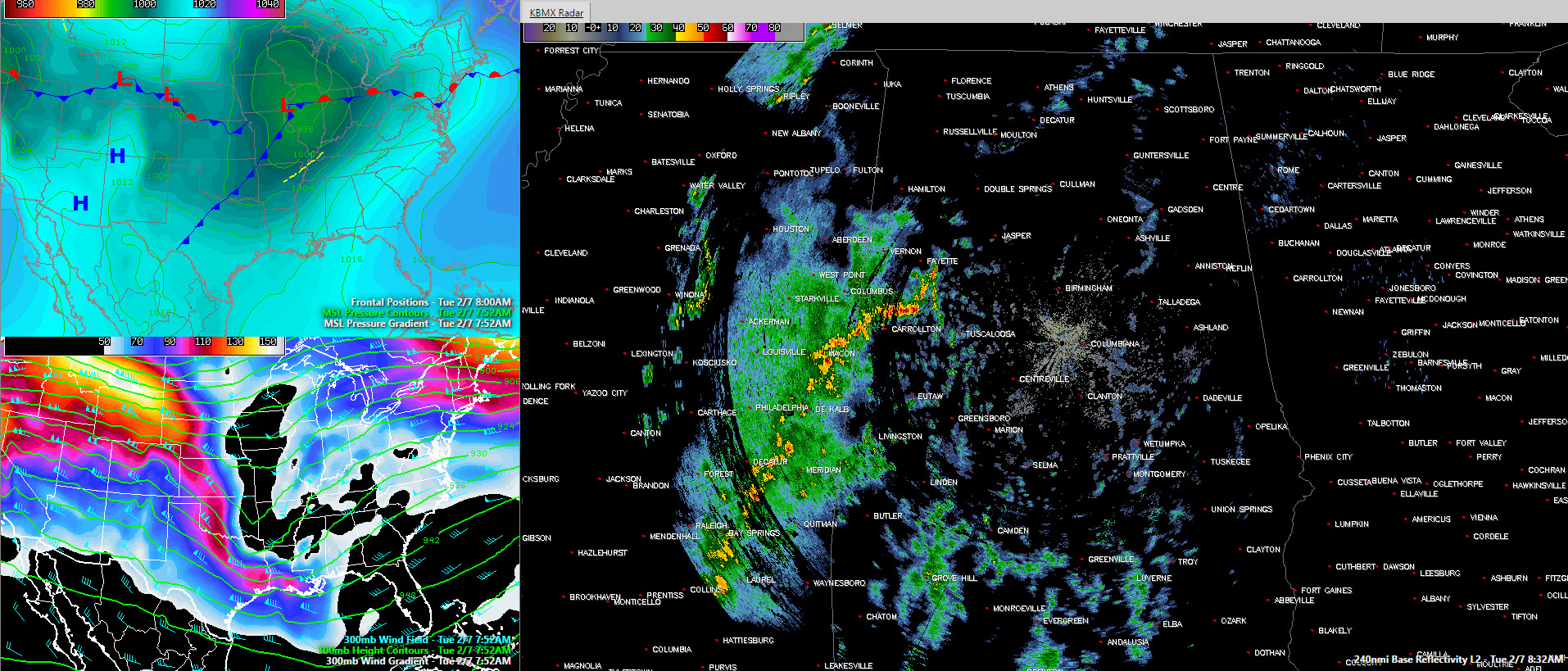
Surface pressures and fronts top left, 35,000 winds and heights bottom left and current Birmingham radar large panel
In the upper atmosphere, a strong shortwave trough or upper level disturbance was shifting eastward across the Arklatex. Strong jet stream level winds of 90-100 knots are rounding the base of this smaller trough and helping to enhance thunderstorms over Louisiana and Mississippi. The northern end of those storms are now moving into Lamar, Fayette, Pickens, Sumter and Greene Counties. They extend back into southern Mississippi near Laurel. These storm will lift northeastward across much of Central Alabama this morning. Lots of lightning with these storms as they come into Alabama, but they aren’t severe for now.
The more unstable air is back over Louisiana now, associated with colder air aloft that is overspreading the region. This unstable air will move into southern Mississippi and later Southwest Alabama during the day with a threat of large hail and the possibility of a few tornadoes.
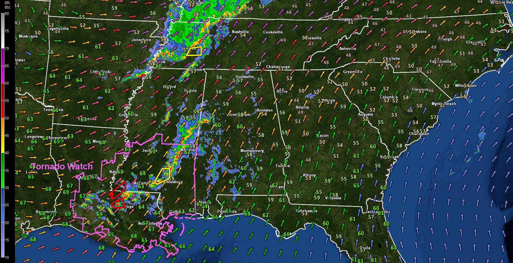
Current regional radar, showing tornado watch and severe thunderstorm and tornado warnings. Dewpoints shown numerically and winds at 5,000 feet with arrows. Red and purple show highest wind speeds.
A tornado watch was just issued for all of southern Mississippi and the southeastern half of Louisiana. Two tornado warnings right now around Baton Rouge. A funnel clouds was just sighted in East Baton Rouge Parish.
To the northwest, strong storms are occurring over eastern Arkansas, western Tennessee and northern Mississippi. There a couple of severe thunderstorm warnings along I-40 between Memphis and Jackson in Tennessee. Those storms are associated with a strong low level jet that is blowing northward across much of Louisiana, Arkansas, western Tennessee and Kentucky.
Across Central Alabama, a little sun is trying to break through, but for western sections that will be temporary with the dense mass of clouds coming from Mississippi now. Temperatures are in the upper 50s over North Alabama and lower 60s over Central Alabama. Dewpoints have reached 60F south of I-20 and will be increasing through the day.
The first batch of storms will pass through Tuscaloosa between now and 10 a.m. reaching Birmingham before 11 a.m. Between 11 and 1 p.m., thunderstorms will cross I-59, and weaken over East Alabama. Storms should develop behind this main line through mid-afternoon. These storms will pose a threat of damaging winds.
So, the first round will be noisy, with lots of thunder and lightning and some gusty winds.
The second round will affect areas near and north of I-20 with the threat of damaging winds this afternoon. The main threat will be from 11 a.m. – 1p.m. over the West, and 2-4 p.m. from Jasper to Cullman to Birmingham, Gadsden and Anniston.
Further south, the most dangerous storms will affect South Alabama from 1 p.m. until 8 p.m. this afternoon and evening. Large hail and a tornado threat will accompany these storms.
We will be covering the severe weather threat closely through the day with at least hourly updates and the latest warnings instantly. We will be testing a new system that will display a simple polygon with every new warning and then update that warning continuously until it is canceled or expires. With each update there will be a new updated polygon. Practice finding your community and know if you are in or out of the warning. Remember: Respect the Polygon!
Category: Severe Weather
About the Author (Author Profile)
Bill Murray is the President of The Weather Factory. He is the site's official weather historian and a weekend forecaster. He also anchors the site's severe weather coverage. Bill Murray is the proud holder of National Weather Association Digital Seal #0001 @wxhistorianSubscribe
If you enjoyed this article, subscribe to receive more just like it.


