

Strong Indications of a Tornado Approaching Hammond, Covington, Mandeville Areas in Louisiana
PDS TORNADO WARNING
The NWS in Slidell has issued a rare PDS Tornado Warning for the storm crossing I-55 south of Hammond.
It is moving toward Mandeville and Covington.
Here is a partial text of the warning:
BULLETIN – EAS ACTIVATION REQUESTED
Tornado Warning
National Weather Service New Orleans LA
1032 AM CST TUE FEB 7 2017
The National Weather Service in New Orleans has issued a
* Tornado Warning for…
Southeastern Tangipahoa Parish in southeastern Louisiana…
Northeastern St. John The Baptist Parish in southeastern
Louisiana…
West central St. Tammany Parish in southeastern Louisiana…
East central Livingston Parish in southeastern Louisiana…
* Until 1100 AM CST
* At 1032 AM CST, a confirmed large and extremely dangerous tornado
was located 8 miles southeast of Springfield, or 12 miles south of
Hammond, moving east at 30 mph.
This is a PARTICULARLY DANGEROUS SITUATION. TAKE COVER NOW!
HAZARD…Damaging tornado.
SOURCE…Radar confirmed tornado.
IMPACT…You are in a life-threatening situation. Flying debris
may be deadly to those caught without shelter. Mobile
homes will be destroyed. Considerable damage to homes,
businesses, and vehicles is likely and complete
destruction is possible.
* Locations impacted include…
Madisonville, Killian and W Lk Pontchartrain Buoy.
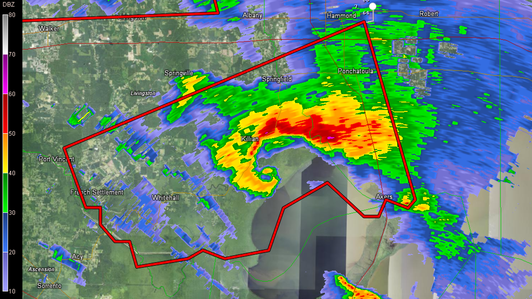
IMPRESSIVE HOOK ECHO
Here is an image from the New Orleans International Terminal Doppler Radar of the supercell storm passing south of Hammond LA. Look at that hook echo! There is also a possible debris ball as well. Lofted debris is indicated as well.
It is passing near Killian and will cross I-55 between Ponchatoula and Akers.
ORIGINAL POST
A dangerous supercell storm is going to pass just south of Hammond LA in the next 30 minutes and will move toward the Convington/Mandeville areas on the northshore of Lake Ponchartrain.
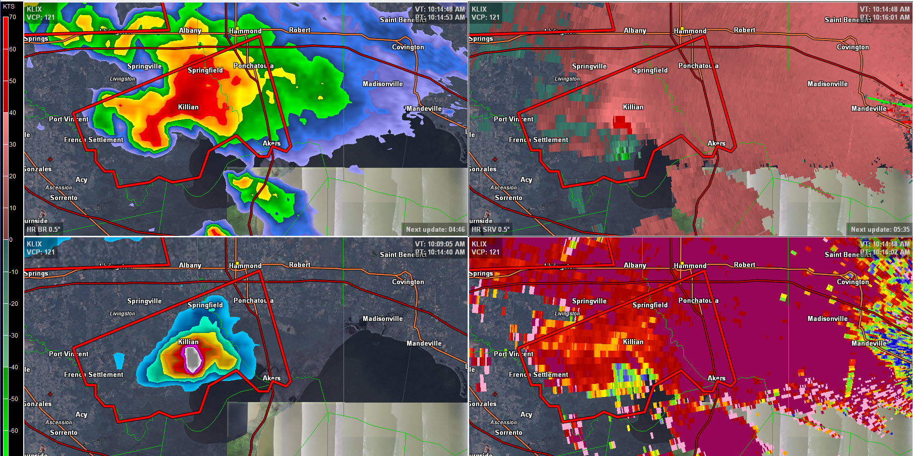
Top left: reflectivity; top right storm relative velocity, bottom right: correlation coefficient showing TDS and bottom left, VIL showing large hail.
The storm has really rampedup in the past few minutes, now showing a distinct notch and moderate gate to gate shear. A definite hook has developed. There may be a tornado debris signature (TDS), and there is a TVS, or tornado vortex signature and strong low level rotation.
Very large hail is now falling as well. Hail to 1.5 inches is possible.
Category: Headlines
About the Author (Author Profile)
Bill Murray is the President of The Weather Factory. He is the site's official weather historian and a weekend forecaster. He also anchors the site's severe weather coverage. Bill Murray is the proud holder of National Weather Association Digital Seal #0001 @wxhistorianSubscribe
If you enjoyed this article, subscribe to receive more just like it.


