

Rain Tapers Off Tonight; More Storms Tomorrow?
RADAR CHECK: Widespread rain and thunderstorms are over Alabama this afternoon… thankfully the rain moved in early enough in the day to keep the air stable and mitigate the severe weather threat for the northern half of the state. A tornado watch remains in effect for parts of Southwest Alabama until 6pm…
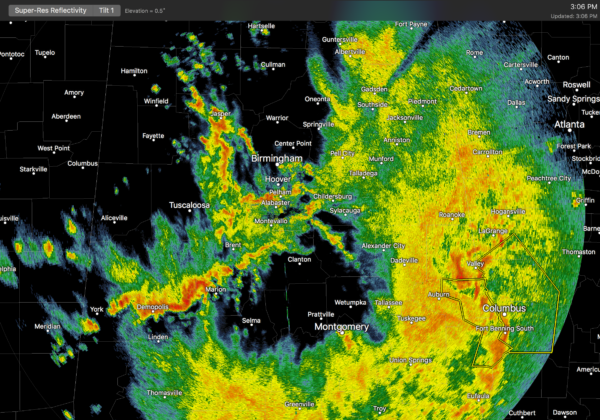
Rain and storms will end this evening from west to east as the lead short wave aloft passes on to the east. The severe weather threat this evening will be confined to far South Alabama, where the air is more unstable.
TONIGHT: Clouds linger, and we don’t expect anything more than a few scattered showers; the low overnight will be in the mid 50s.
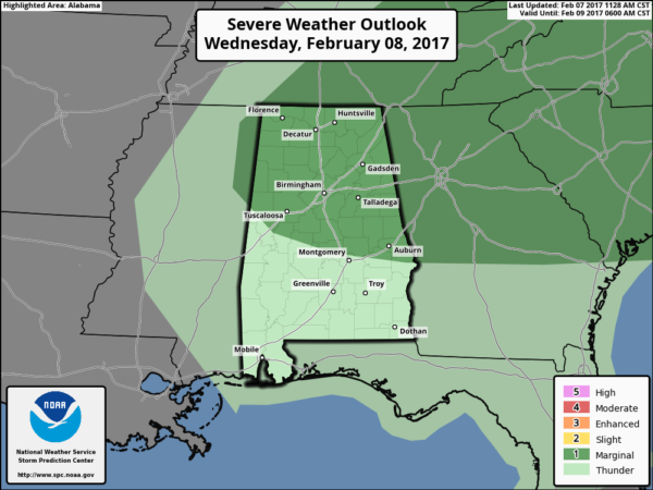
MORE STORMS TOMORROW? One thing is for sure, tomorrow will be a warm February day with a high in the mid 70s. And, with a cold front approaching, there is a chance we could see a few more storms, but nothing as widespread as today. In fact, with a capping inversion expected, a decent part of the day will be dry, and many places will see no rain at all. But, where the cap does break, storms could be strong to severe with potential for hail and strong winds. SPC maintains a “marginal” risk of severe storms for the northern half of the state tomorrow…
MUCH COLDER THURSDAY/FRIDAY: The sky becomes mostly sunny Thursday, but the day will be breezy and sharply colder with temperatures holding in the 40s. Then, we drop into the 25-29 degree range early Friday morning as the cold air settles into the state. Friday will be cool and dry with a high in the mid 50s.
THE ALABAMA WEEKEND: Saturday looks mostly dry, although a few isolated showers could show up over the northern quarter of the state by afternoon. And, we turn warmer with temperatures rising into the upper 60s. Sunday looks like a mostly cloudy, mild day with with only widely scattered showers; the high Sunday will be in the low 70s.
NEXT WEEK: A dynamic weather system will move into Alabama with rain and storms Wednesday night and Thursday. The latest GFS run (12Z) shows a surface low moving right through Central Alabama; see the Weather Xtreme video for maps, graphics, and more details.
WEATHER BRAINS: Don’t forget you can listen to our weekly 90 minute netcast anytime on the web, or on iTunes. This is the show all about weather featuring many familiar voices, including our meteorologists here at ABC 33/40.
CONNECT: You can find me on all of the major social networks…
Facebook
Twitter
Google Plus
Instagram
Pinterest
Snapchat: spannwx
I had a great time today seeing the 2nd and 6th graders at Oneonta City School in Blount County… be looking for them on the Pepsi KIDCAM on ABC 33/40 News at 5:00! The next Weather Xtreme video will be posted here by 7:00 a.m. tomorrow…
Category: Alabama's Weather
About the Author (Author Profile)
James Spann is one of the most recognized and trusted television meteorologists in the industry. He holds the AMS CCM designation and television seals from the AMS and NWA. He is a past winner of the Broadcast Meteorologist of the Year from both professional organizations.Subscribe
If you enjoyed this article, subscribe to receive more just like it.


