

The Weather Roundup for 2/8/17: Record Highs to Big Time Snows
TUESDAY’S SEVERE WEATHER
A few photos from tornado damage in NO East indicating EF3 damage. Bent metal transmission lines & complete loss of roof on multiple homes pic.twitter.com/Fe8lsVdE1c
— NWS New Orleans (@NWSNewOrleans) February 8, 2017
Latest update from the survey team exploring the damage in New Orleans East caused by the tornado has been rated as an EF-3. There is no current estimated wind speed as of yet, but that will be released later today. Images posted on the NWS New Orleans Twitter feed show multiple homes with a complete loss of their roof, along with metal transmission lines bent. This tornado is now considered the strongest to move through Orleans Parish. It is the first recorded EF-3 tornado, with the previous strongest only rated as an EF-2.
Along with that update from New Orleans, we also have an incredible story of survival to go along with it. A young mother was at work at a local impound yard, that is located near to the NASA Michoud Assembly Facility. She brought her 8-week old child with her to work as she had a doctor’s appointment to go to. She heard the tornado approaching, so she buckled the baby up in its pumpkin seat and both sought shelter underneath her desk. The tornado then tosses the office trailer over and destroys it, and both mother and child were tossed up in the air. She wrapped her arms tightly around the handle of the seat and never lost hold as they both flew through the debris-filled air. Both came crashing back down to the ground, but miraculously only receiving very minor injuries.
Even though this is a great story coming out of a destructive event, this is a main reason why a trailer or mobile home can not be used as shelter during a tornadic event. If it is not anchored securely to the ground, a strong wind gust can easily flip the trailer over or collapse the walls onto the contents inside.
Damage that occurred in Andalusia (Covington County, Alabama) during Tuesday’s event was caused by a tornado rated as EF-0. Damage that occurred in Opelika (Lee County, Alabama) was caused by damaging straight-line thunderstorm winds, estimated to be around 60-70 MPH.
CALIFORNIA’S WATER STORY
The water year in Northern California has been a banner one. Parts of the Sierra Nevada mountains have picked up over 600% of normal in the past 90 days.
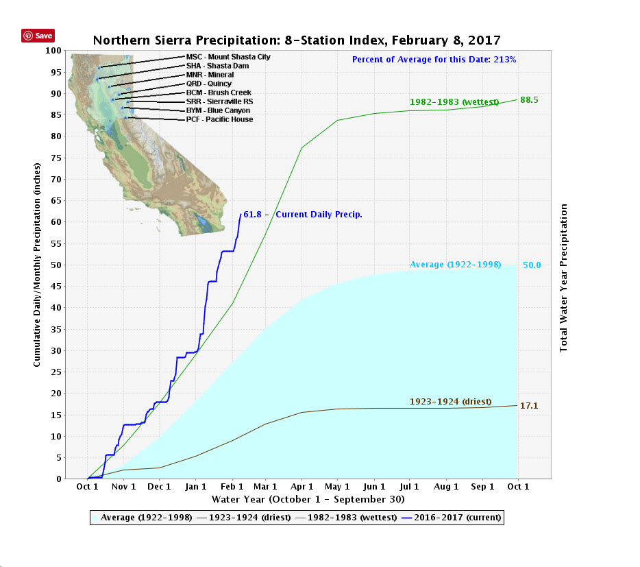
The average of 8 stations in the Northern Sierra so far since October 1st, the beginning of their water year, is 61.8 inches. That 213% of normal. Their wettest year is 1982-83, when the average was 88.5 inches.
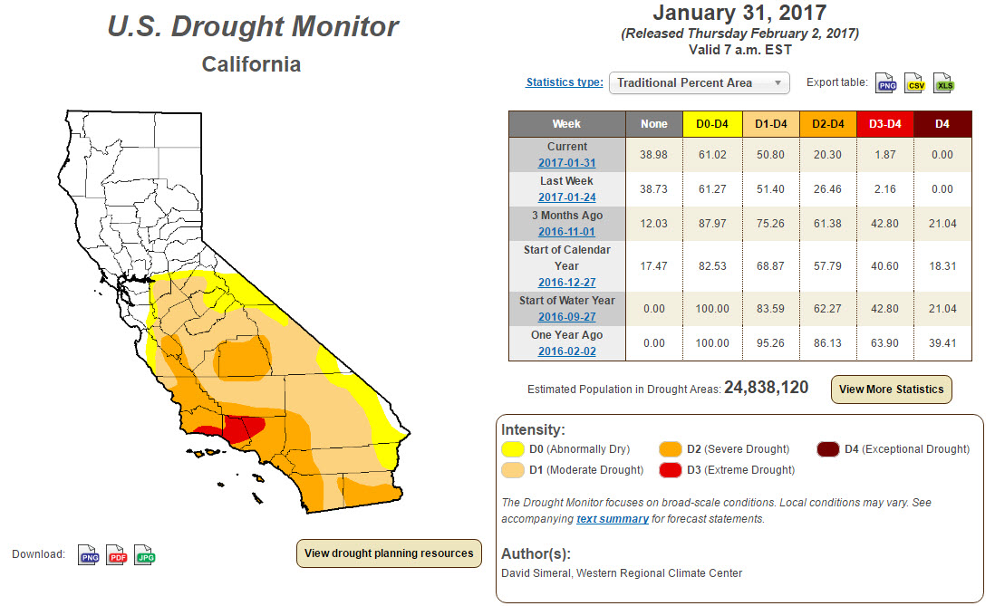
California’s drought situation has improved radically in the past three months. None of the state is in exceptional drought, whereas 21.04% was three months ago. Now 50% of the state is in some form of drought. At the start of the water year, it was 83.6%
More precipitation is on the way…
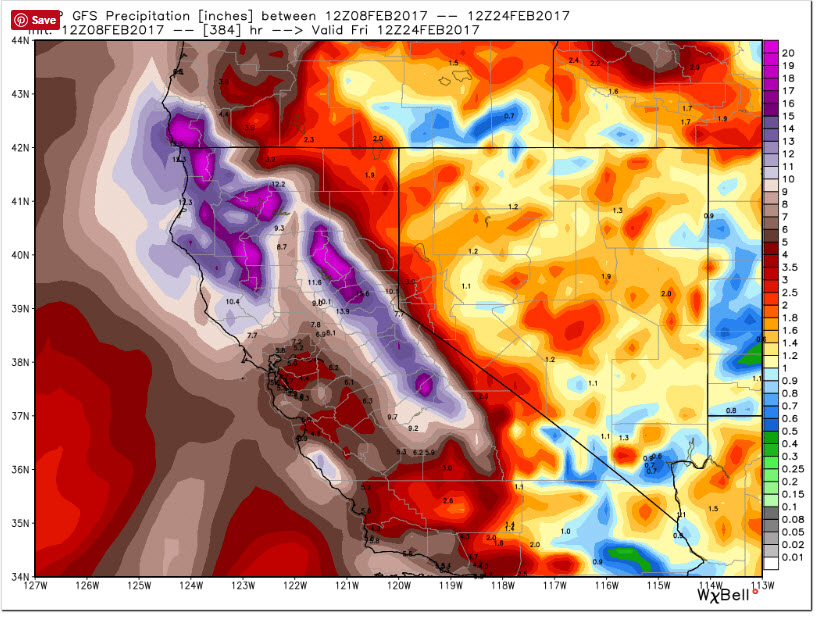
This is the GFS 16 day total projected liquid equivalent precipitation for Northern California. That’s up to 14 inches in the northern Sierra. Not snow. Liquid equivalent. Snow looks like this:
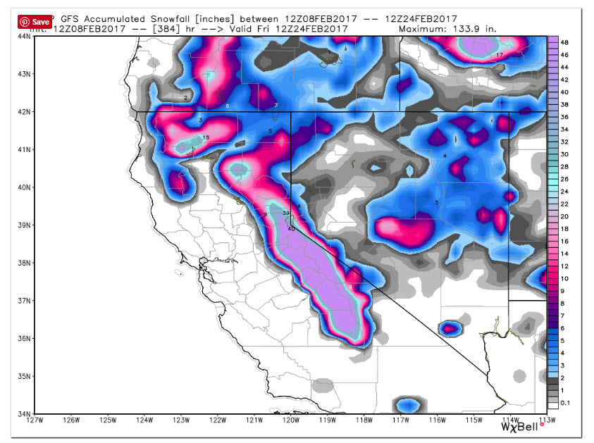
That’s widespread 4 foot+ amounts across the Sierras. And the max shown is 133.9 inches in there somewhere. That’s nearly 12 feet of snow for someone! Such great news for our friends in California.
The flooding that some of the rain caused yesterday was not good news. There were numerous reports of washed out roads and roads blocked by debris across Marin County and Napa as well as the San Joaquin Valley yesterday. Several flash flood warnings were in effect.
Today, a massive areal flood warning covers much of interior northern California. The warning covers 28,427 square miles. That’s a big warning! And a grand total of 4,556,832 people are in the warning. I can hear the national news tonight. Millions and millions in the path!!
Rainfall has been coming down impressively for southern California throughout the end of 2016 and through the beginning of 2017. As of this morning, the NWS Los Angeles official measurements have 15.44 inches of rain since October 1st. This may not sound all that impressive to us, but this is already greater than what LA averages for a whole year (October 1st – September 30th). LA’s average yearly rainfall is only 14.93 inches. Say woohoo to a surplus.
Just within the last 72 hours, several locations in California have picked up nice amounts of precipitation. Los Angeles and Santa Barbara have both received close to ½ inch, while places in the northern parts of the state received over 1-½ inches.
RECORD HIGHS AND WINTER WEATHER WARNINGS
Record high temperatures have already been set today in places that are in a winter storm warning starting tonight. Winter storm warnings are now posted from Wilmington DE to Gloucester, MA, north of Boston.
The temperature reached 69F at Atlantic City at 11:07 this morning, tying the record for the date. Philadelphia broke their record with 64F. In WIlmington, the temperature reach 70F at 11:13 this morning, smashing the old record of 66F.
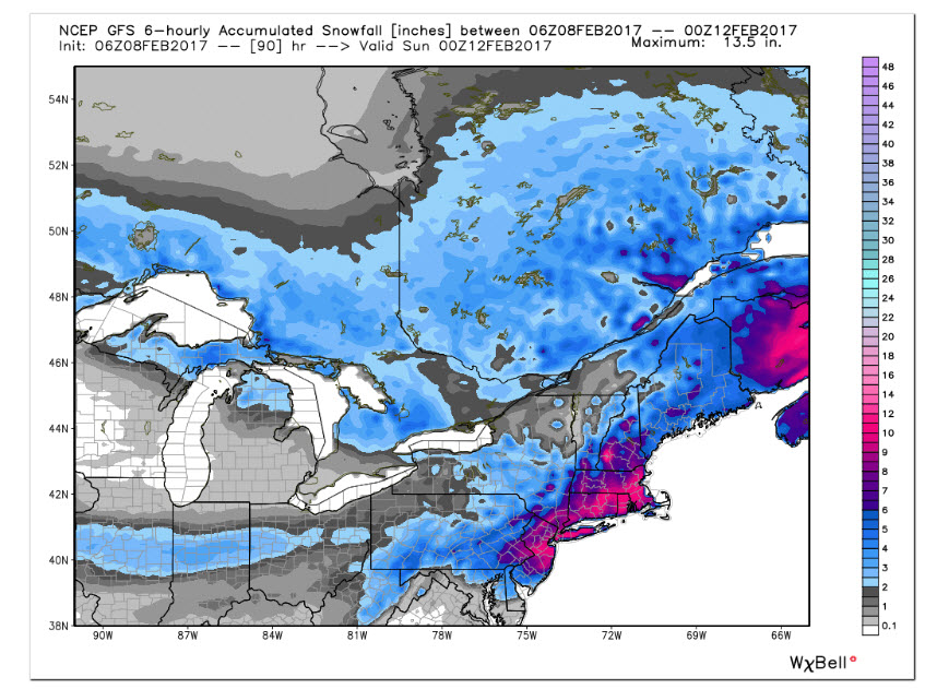
Snowfall amounts are projected to reach 3-6 inches around WIlmington, 6-10 inches around NYC and 8-14 inches across Connecticut, Rhode Island and Massachusetts. Blizzard warnings are in effect for the Cape and Nantucket in Massachusetts.
Records around the Big Apple today include 65F at JFK, 61F at LaGuardia and 65F at Newark.
At Reagan National Airport in DC, they broke their record high for the second day in a row. Today’s 74F smashed the old record of 66F. This followed on the heels of yesterday’s 73F. D.C. may be left out of the snowfall fun. Less than one half inch of snow expected in the District.
Category: Headlines
About the Author (Author Profile)
Scott Martin is an operational meteorologist, professional graphic artist, musician, husband, and father. Not only is Scott a member of the National Weather Association, but he is also the Central Alabama Chapter of the NWA president. Scott is also the co-founder of Racecast Weather, which provides forecasts for many racing series across the USA. He also supplies forecasts for the BassMaster Elite Series events including the BassMaster Classic.Subscribe
If you enjoyed this article, subscribe to receive more just like it.


