

Severe Storms Possible Tonight
THIS AFTERNOON: The sun is breaking through the clouds over Alabama this afternoon, with temperatures generally in the 68-72 degree range. Radar is quiet, but it should light up later tonight with a cold front slicing through the state.
SPC now has much of North and Central Alabama in the standard “slight risk” of severe storms, with a “marginal risk” down to Montgomery…
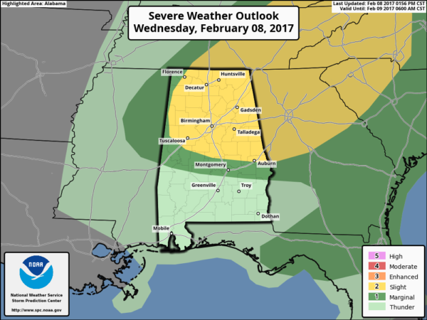
TIMING: The line of storms will begin to form between 6 and 7:00 over Northwest Alabama, reaching Birmingham/Tuscaloosa/Gadsden around 8:00… Anniston close to 9:00. The storms will be out of the area by 11:00.
THREATS: The main issues will be hail and strong straight line winds, but models have become more aggressive with helicity values, and we will need to introduce the risk of an isolated tornado or two. STP (Significant Tornado Parameter) values have increased to 2-3 units ahead of the front.
Just be sure you have way of hearing severe weather warnings tonight in the event they are needed.
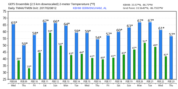
TOMORROW/FRIDAY: Much colder air blows into the state tomorrow; the day will be sunny, but breezy and very cool with a high in the 48-51 degree range. We drop below freezing by early Friday morning with a low between 25 and 30 degrees for most communities. Friday will be sunny with a high close to 60.
THE ALABAMA WEEKEND: Another quick warm-up; we expect afternoon highs around 70 degrees both days. Saturday will be mostly dry with a mix of sun and clouds… any showers should be confined to far North Alabama. Then, on Sunday, the sky will be mostly cloudy, and we will mention scattered showers. But, nothing especially heavy or widespread.
NEXT WEEK: The chance rain looks fairly low Monday and Tuesday thanks to a cooler, drier airmass, but rain is a good bet sometime in the Wednesday/Thursday time frame as a potent upper low lifts out of South Texas. See the Weather Xtreme video for maps, graphics, and more details.
WEATHER BRAINS: Don’t forget you can listen to our weekly 90 minute netcast anytime on the web, or on iTunes. This is the show all about weather featuring many familiar voices, including our meteorologists here at ABC 33/40.
CONNECT: You can find me on all of the major social networks…
Facebook
Twitter
Google Plus
Instagram
Pinterest
Snapchat: spannwx
I enjoyed seeing the students today at Cross at Clay Academy… be looking for them on the Pepsi KIDCAM today at 5:00 on ABC 33/40 News! The next Weather Xtreme video will be posted here by 7:00 a.m. tomorrow, and keep an eye on the blog tonight as the storms develop along the cold front.
Category: Alabama's Weather
About the Author (Author Profile)
James Spann is one of the most recognized and trusted television meteorologists in the industry. He holds the AMS CCM designation and television seals from the AMS and NWA. He is a past winner of the Broadcast Meteorologist of the Year from both professional organizations.Subscribe
If you enjoyed this article, subscribe to receive more just like it.


