

Rain Arrives Late Tomorrow Night
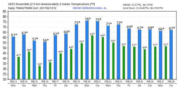
PLEASANT AFTERNOON: With a sunny sky, temperatures are in the 50s and 60s across the northern half of Alabama this afternoon. Tonight will be clear and chilly; most places will wind up in the 36-42 degree range early tomorrow morning.
MID-WEEK RAIN: Clouds will move into the state tomorrow ahead of a weather system to the west that will bring the risk of severe storms to Southeast Texas (including Houston) and the western Gulf Coast region during the day. Rain should move into West Alabama late tomorrow night, continuing into Wednesday morning. The surface low should move roughly along U.S. 80, meaning the northern half of Alabama will be in a cool, stable airmass. So, for places like Birmingham, Tuscaloosa, Anniston, and Gadsden, we expect just a steady rain with temperatures in the 40s. Rain amounts between 1/2 and 1 inch are expected.
The main window for rain comes from midnight tomorrow night through 12:00 noon Wednesday.
TO THE SOUTH: SPC has defined the standard “slight risk” of severe storms near the Gulf Coast tomorrow night and early Wednesday in the “Day Two” convective outlook…
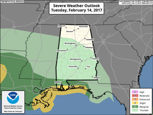
Severe storms will be possible tomorrow night for places like Mobile, Gulf Shores, Pensacola, and Fort Walton Beach.
THURSDAY/FRIDAY: Thursday will be cool and dry wth a sunny sky; the day begins with sub-freezing temperatures (mostly between 28 and 32 degrees), followed by a high in he mid 50s. Sunny weather continues on Friday with a high in the low 60s.
THE ALABAMA WEEKEND: A disturbance will bring some clouds into the state Saturday, and I guess we probably need to mention the risk of isolated showers, but most of the day should be dry with a high in the mid 60s. The main chance of rain with this system will be well to the south, over the Gulf of Mexico. Sunday promises to be a beautiful day with ample sunshine and a high close to 70 degrees.
NEXT WEEK: Monday and Tuesday look dry and mild… then showers and storms should move back into the state by Wednesday. Model consistency is not very good; too early to know if severe storms will be an issue. See the Weather Xtreme video for maps, graphics, and more details.
WINTER OVER? While there is no sign of any really cold, Arctic air shots over the next 15 days, I remind you we almost always have some very sharp cold snaps here in March and April… way too early to even think about putting away winter clothes.
WEATHER BRAINS: Don’t forget you can listen to our weekly 90 minute netcast anytime on the web, or on iTunes. This is the show all about weather featuring many familiar voices, including our meteorologists here at ABC 33/40. We will produce this week’s show tonight at 8:30 CT… you can see it live here.
CONNECT: You can find me on all of the major social networks…
Facebook
Twitter
Google Plus
Instagram
Pinterest
Snapchat: spannwx
I had a great time today visiting with the kindergarten students at Alexandria Elementary… be looking for them on the Pepsi KIDCAM today at 5:00 on ABC 33/40 News! The next Weather Xtreme video will be posted here by 7:00 a.m. tomorrow…
Category: Alabama's Weather
About the Author (Author Profile)
James Spann is one of the most recognized and trusted television meteorologists in the industry. He holds the AMS CCM designation and television seals from the AMS and NWA. He is a past winner of the Broadcast Meteorologist of the Year from both professional organizations.Subscribe
If you enjoyed this article, subscribe to receive more just like it.


