

Sunny Skies And Nice Temperatures Across Central Alabama At The Midday Hour
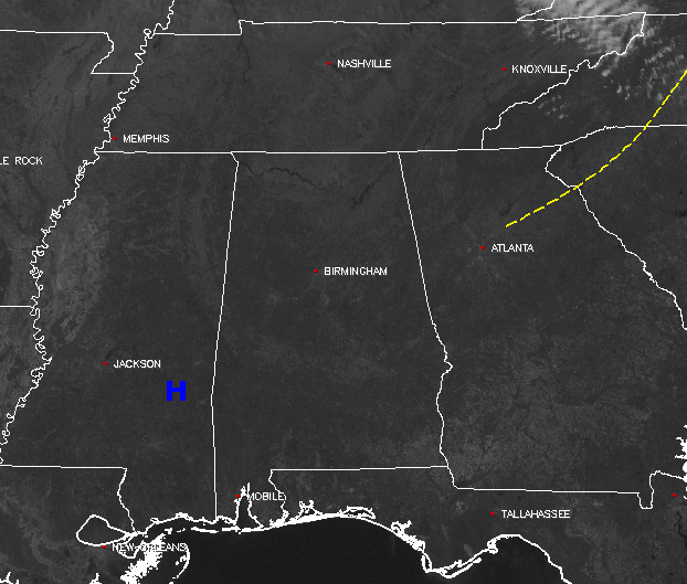
At the midday hour across Central Alabama, the sun is shining and not a single cloud can be found anywhere across the area on the visible satellite image. The entire southeastern United States is free from any rainfall, and only the eastern parts of Kentucky and Tennessee, and the western parts of Virginia and North Carolina are covered by clouds.
The sun will be out in full force for the remainder of the daylight hours across Central Alabama, and it will fell rather nice outside. Afternoon highs will be in the lower to mid 60s across the area. It will be rather chilly again for tonight, but skies will be clear. You should have no issue with seeing the International Space Station fly over, starting at 6:06 PM in the northwestern sky, and moving to the east-southeast. You should be able to see it for approximately 6 minutes. Temperatures at that time will be in the lower to mid 50s, then will be dropping into the mid to upper 30s for the overnight lows.
Temperatures Across Central Alabama
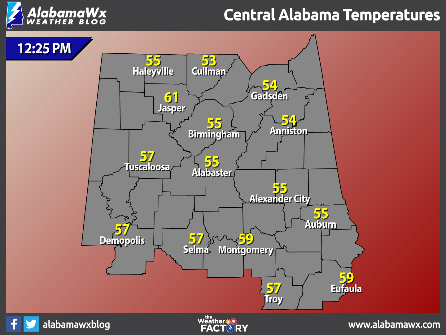
At 12:25 PM, temperatures are ranging from the lower 50s to the upper 50s across the area. The warm spots are currently Montgomery and Eufaula at 59º. The cool spot is Cullman at 53º. Jasper is showing a temperature at 61º, but that is hard to believe with the surrounding locations showing well lower temperatures.
Birmingham’s Climatology And Records
The normal high for February 16th is 59º, while the normal low is 37º. The record high for today was set back in 2001 at 80º. The record low was set back in 1958 at 11º.
Not A Bad Looking Friday
Skies will be clear during the morning hours, but clouds will begin to move in from the southwest during the afternoon hours. Afternoon highs will be in the upper 60s to the lower 70s across the area. A shortwave will move across the area from southwest to northeast during the evening and overnight hours. The air at the lower levels will be rather dry, so it will take a while for it to saturate enough for rain to reach the ground, so the better chance of rain falling will be at or after midnight in the west and southwestern locations. Amounts will be rather light, less than 1/10th of an inch. Overnight lows will be in the mid to upper 40s.
What To Expect At The Beach
Sunny skies for the remainder of today, but clouds return on Friday ahead of rain and a few claps of thunder for Friday night and Saturday. The sun returns for Sunday and Monday before the next chance of rain on Tuesday. Highs will be in the 60s through tomorrow, then warming into the 70s for Sunday through Tuesday. Click here to see the Beach Forecast Center page. Save Up To 25% With Brett Robinson Vacation Rentals! The Beach Forecast is partially underwritten by the support of Brett Robinson Vacation Rentals, who has great Spring Break savings right now. Click here to visit their Specials & Promotions page..
National Extremes
The warmest high temperature set for the nation on Wednesday afternoon was 87º, set in three different locations in Florida. The coldest low temperature for this morning was -9º, set 6 miles east of Champion, Michigan. The highest precipitation total for the 24 hour period starting at 12PM Wednesday to 12PM today is 1.90 inches at Augusta, Georgia.
On This Day In Weather History: 1990
Strong thunderstorms developing ahead of an arctic cold front produced severe weather across the southeastern U.S. between mid morning on the 15th and early evening on the 16th. Thunderstorms spawned thirteen tornadoes, including one which, prior to dawn on the 16th, injured eleven persons near Carrollton GA. There were also 121 reports of large hail or damaging winds. A late afternoon thunderstorm on the 15th produced baseball size hail at Jackson MS, and prior to dawn on the 16th, a thunderstorm produced high winds which injured four persons at Goodwater AL.
Follow The Blog On Social Media
Remember that we are also on Facebook and on Twitter.
WeatherBrains
To hear the latest of the weekly netcast that’s all about weather featuring many familiar voices, including our meteorologists at ABC 33/40, you can listen anytime on the web at Weatherbrains.com, or on iTunes.
Forecaster: Scott Martin (Twitter: @scottmartinwx)
Category: Alabama's Weather
About the Author (Author Profile)
Scott Martin is an operational meteorologist, professional graphic artist, musician, husband, and father. Not only is Scott a member of the National Weather Association, but he is also the Central Alabama Chapter of the NWA president. Scott is also the co-founder of Racecast Weather, which provides forecasts for many racing series across the USA. He also supplies forecasts for the BassMaster Elite Series events including the BassMaster Classic.Subscribe
If you enjoyed this article, subscribe to receive more just like it.


