

Clouds Are On The Increase At Midday, With Rain Likely Later Tonight & Tomorrow
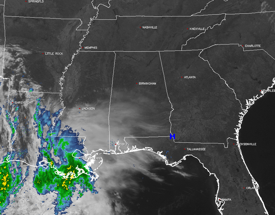
Clouds have already moved into the southwestern parts of the area, but most of Central Alabama are enjoying mostly clear skies at the midday hour. Looking back to our west and southwest, showers and thunderstorms are currently falling of parts of southwestern Mississippi, eastern Louisiana, and back into southeastern Texas. The rest of the southeast at this time is pretty much enjoying clear skies.
With a southwesterly flow in place, we will have a pretty mild afternoon across Central Alabama. Along with those warm temperatures, that state flow will start to feed clouds into the area. Afternoon highs will be in the mid 60s to the lower 70s throughout the area. An upper level trough will be approaching the area, bringing in more clouds and a decent chance of rain for tonight. This system doesn’t have a lot of moisture with it, but should be enough for light to moderate showers to fall across much of the area. Overnight lows will be in the mid to upper 40s, with a few spots at or near 50º. The better chances of rain will be in the southwestern parts of the area, but all of Central Alabama will have a decent chance of rain.
Temperatures Across Central Alabama
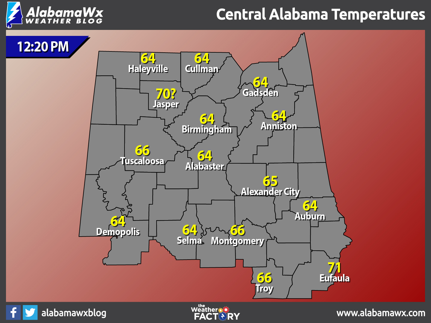
At 12:20 PM, temperatures are ranging from the mid 60s to the lower 70s across the area. The warm spot is currently Eufaula at 71º. There are 9 different locations tied as the cool spot 64º.
Birmingham’s Climatology And Records
The normal high for February 17th is 59º, while the normal low is 36º. The record high for today was set back in 1976 at 79º. The record low was set back in 1958 at 3º.
The Weekend Ahead
On Saturday, showers will be likely at times during the morning hours, especially east of the I-65 corridor. The highest chances for rain will be during the early morning hours, before a dry slot moves in. As an upper low moves over the area, some redevelopment of showers is possible during the afternoon, especially over the southeastern locations in Central Alabama. A few rumbles of thunder is possible in those locations, but the best instability will stay along the Gulf Coast. Afternoon highs will be in the upper 50s to the upper 60s. As the low moves out during the evening, so does all of the rain. Patchy fog may develop in the southeastern parts of the area, but otherwise skies will be partly to mostly cloudy. Overnight lows will be in the 40s throughout Central Alabama.
What a beautiful and warm day Sunday is going to be. Skies will start off partly cloudy to mostly clear, but clouds will continue to thin out during the day. Afternoon highs will be in the lower to mid 70s throughout the area. Clear skies will be the story for Sunday evening through the overnight hours, and lows will be in the mid 40s to the lower 50s.
What To Expect At The Beach
Increasing clouds through the day today, with rain likely tonight through the day on Saturday. Sun returns for Sunday and Monday, before a chance of showers and thunderstorms on Tuesday and Wednesday. Highs will be in the 60s today and warming into the 70s for tomorrow through Wednesday. Click here to see the Beach Forecast Center page.
Save Up To 25% on Spring Break Beach Vacations on the Alabama Gulf Coast with Brett/Robinson!
The Beach Forecast is partially underwritten by the support of Brett/Robinson Vacation Rentals in Gulf Shores and Orange Beach. Click here to see Brett/Robinson’s best beach offers now!.
National Extremes
The warmest high temperature set for the nation on Thursday afternoon was 83º, set at Indio, California. The coldest low temperature for this morning was -4º, set at Mount Washington, New Hampshire. The highest precipitation total for the 24 hour period starting at 11AM Thursday to 11AM today is 1.39 inches at Fort Worth, Texas.
On This Day In Weather History: 1990
The biggest winter storm of the season hit the Pacific Coast Region. In northern California, snow fell along the coast, and two day totals in the mountains ranged up to 67 inches at Echo Summit. Snowfall totals in the mountains of southern California ranged up to 48 inches at Green Valley, with 46 inches reported at Big Bear. Up to two feet of snow blanketed the southern Cascade Mountains of Oregon, and 20 to 35 inches were reported in the northern Cascades of Oregon.
Follow The Blog On Social Media
Remember that we are also on Facebook and on Twitter.
WeatherBrains
To hear the latest of the weekly netcast that’s all about weather featuring many familiar voices, including our meteorologists at ABC 33/40, you can listen anytime on the web at Weatherbrains.com, or on iTunes.
Forecaster: Scott Martin (Twitter: @scottmartinwx)
Category: Alabama's Weather
About the Author (Author Profile)
Scott Martin is an operational meteorologist, professional graphic artist, musician, husband, and father. Not only is Scott a member of the National Weather Association, but he is also the Central Alabama Chapter of the NWA president. Scott is also the co-founder of Racecast Weather, which provides forecasts for many racing series across the USA. He also supplies forecasts for the BassMaster Elite Series events including the BassMaster Classic.Subscribe
If you enjoyed this article, subscribe to receive more just like it.


