

A Few High Clouds Out There At Midday, But A Great & Warm Day Across Central Alabama
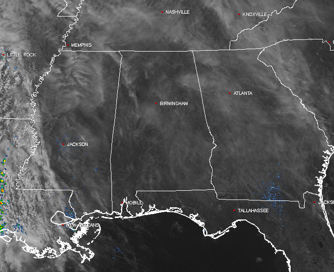
At the midday hour across Central Alabama, we have some high, thin clouds floating overhead that are filtering the sun a little bit, but they are not affecting the temperatures at all. Back to our west, showers and thunderstorms are occurring over the eastern parts of Texas, into the western parts of Louisiana. No severe weather watches or warnings are in effect for these storms, but parts of Texas experienced some damaging wind events with these storms on Sunday. There is a marginal risk for severe storms for most of Louisiana and the eastern parts of Texas, with a low possibility for locally damaging winds and/or a brief tornado for this afternoon into tonight.
For the rest of the day today, skies will remain mostly clear with the occasional high, thin clouds floating overhead. Afternoon highs will be in the mid to upper 70s across Central Alabama. For tonight, clouds will be on the increase, as well as rain chances mainly for the western half of the area. A trough will move across the Plains today and move closer to our area. The surface low that is currently bringing storms to Texas and Louisiana will strengthen and send shower activity into the area during the overnight hours. Lows will be in the lower to mid 50s.
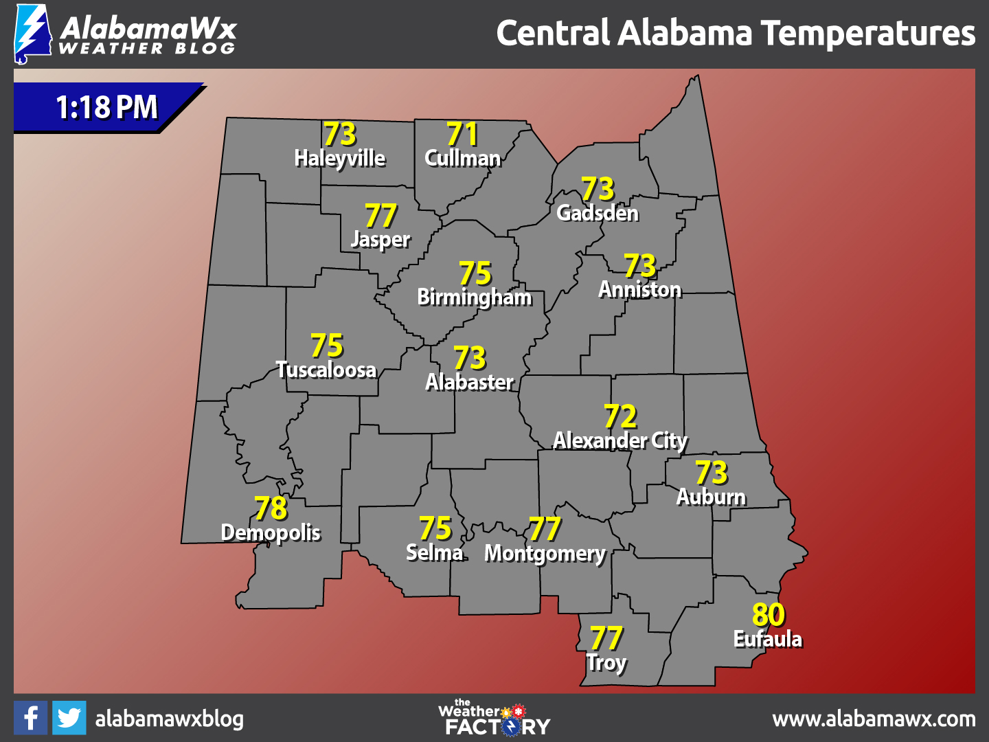
Temperatures Across Central Alabama
At 1:18 PM, temperatures are ranging from the lower 70s to the lower 80s across the area. The warm spot is currently Eufaula at 80ºF. The cool spot is Cullman at 71ºF.
Birmingham’s Climatology And Records
The normal high for February 20th is 60ºF, while the normal low is 36ºF. The record high for today was set back in 1986 at 78ºF. The record low was set back in 1958 at 16ºF.
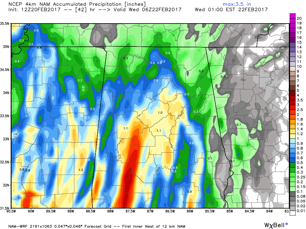
NAM-4k Modeled Rainfall Totals Through 12AM Wednesday
A Wet Day Expected On Tuesday
After rain moves into the western parts of the state during the predawn hours, and moving into the Birmingham area by rush hour. Rainfall looks to be pretty persistent in coverage throughout the day, and totals look to be at or near 1 inch for much of the area, with some spots getting even more. Afternoon highs will make it into the mid 60s to the lower 70s across Central Alabama. Rainfall will continue into the evening hours and through the predawn hours on Wednesday, with lows in the mid to upper 50s.
The Beach Forecast
After pretty nice weather today, rain and thunder is expected for Tuesday and Wednesday. Skies clear out and mostly sunny conditions can be expected from Thursday through the weekend. Highs will be in the 70s, with lows in the 50s and 60s. Click here to see the Beach Forecast Center page.
Save Up To 25% on Spring Break Beach Vacations on the Alabama Gulf Coast with Brett/Robinson! The Beach Forecast is partially underwritten by the support of Brett/Robinson Vacation Rentals in Gulf Shores and Orange Beach. Click here to see Brett/Robinson’s best beach offers now!.
National Extremes
The warmest high temperature set for the nation on Wednesday afternoon was 93ºF, set in McAllen, Texas. The coldest low temperature for this morning was 5ºF, set in Mount Washington, New Hampshire. The highest precipitation total for the last 24 hours is 2.68 inches recorded at Victoria, Texas.
On This Day In Weather History: 1989
Thunderstorms developing during the early afternoon produced severe weather from eastern Texas to Alabama and northwest Florida. Thunderstorms spawned a dozen tornadoes during the afternoon and evening. Thunderstorms also produced 90 mph winds around Vicksburg MS, and 100 mph winds around Jackson MS.
Follow The Blog On Social Media
Remember that we are also on Facebook and on Twitter.
WeatherBrains
To hear the latest of the weekly netcast that’s all about weather featuring many familiar voices, including our meteorologists at ABC 33/40, you can listen anytime on the web at Weatherbrains.com, or on iTunes.
Forecaster: Scott Martin (Twitter: @scottmartinwx)
Category: Alabama's Weather
About the Author (Author Profile)
Scott Martin is an operational meteorologist, professional graphic artist, musician, husband, and father. Not only is Scott a member of the National Weather Association, but he is also the Central Alabama Chapter of the NWA president. Scott is also the co-founder of Racecast Weather, which provides forecasts for many racing series across the USA. He also supplies forecasts for the BassMaster Elite Series events including the BassMaster Classic.Subscribe
If you enjoyed this article, subscribe to receive more just like it.


