

Midday Nowcast: Some Sun, Spring-Like Warmth
After the foggy and cloudy start to our day for many of us, the sky has cleared some, but we are still dealing with clouds and we are seeing plenty of peeks of sunshine. Through the afternoon, we should end up seeing a fair amount of sunshine as we should see more of the clouds erode away.
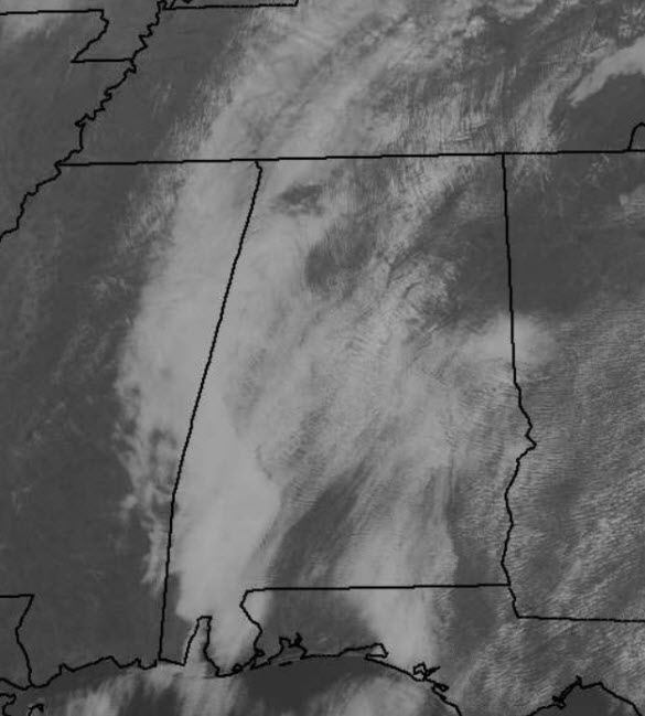
Late this morning, temperatures are already in the upper 60s, and by later today, temperatures are expected to climb into the mid and upper 70s this afternoon; that is 15-20 degrees above average for this time of year.
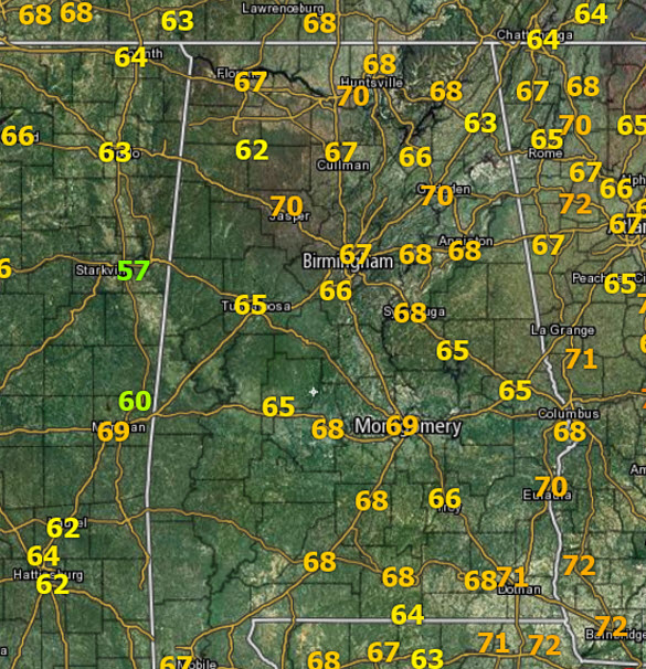
For February 23rd, the average high for Birmingham is 61°, while the record is 83°, set back in 1996. Not going to set a new record today, but the very warm temperatures will only cause more folks to catch spring fever as overall, it will be a very nice afternoon.
FOR TONIGHT: We are going to continue to see partly cloudy conditions, but temperature will stay very mild for February. Our average low this time of year is 39°, but tonight, we are going to stay on the mid and upper 50s overnight. There could be some areas of fog once again develop after midnight.
FINAL FEBRUARY FRIDAY: Record highs are likely across much of Alabama tomorrow, with upper 70s and lower 80s expected. The record high on February 24 for Birmingham is 78° set back in 1930, and I really think we are going to surpass that as we are forecasting 80° tomorrow; some locations in South Alabama will be in the lower and perhaps mid 80s. Tomorrow will have a mix of sun and clouds, but late in the day we are expecting clouds to increase as a cold front approaches the state, but the day Friday will be dry in Alabama.
SEVERE WEATHER OUTBREAK TOMORROW: Not here of course, but for our friends to the north across the Ohio Valley and Great Lakes. On the maps, a deep surface low with good upper support will move toward the Great Lakes the next 24 hours. Heading through the day tomorrow, blizzard conditions will develop over parts of Iowa and Minnesota in the cold air sector of the storm. And, south and east of the surface low, in the warm sector, severe storms are likely tomorrow and tomorrow night. The SPC has much Indiana and Ohio, as well as portions of Michigan and Kentucky in an “enhanced risk” for severe storms tomorrow, while down into Tennessee, and far Northeast Alabama, there is a “marginal risk. ”
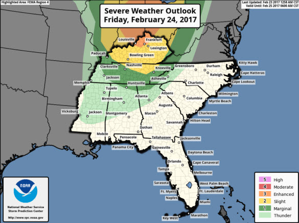
Supercells and the threat of tornadoes are expected up north, however, nothing like that in Alabama as the best dynamics stay well north of the state. What we are expecting in Alabama is a band of showers and storms to move through the state tomorrow night ahead of the trailing cold front. Rain and some thunder is possible, but this should be a thin line of storms and will not produce much rain with rainfall totals below one-quarter inch for most of us. As the front exits rapidly early Saturday, cooler weather arrives for the weekend.
SOLAR WIND ADVISORY: Earth is about to enter a stream of solar wind flowing from a hole in the sun’s atmosphere. NOAA forecasters estimate a 60% chance of polar geomagnetic storms on Feb. 23rd as the solar wind speed quickens to 550 km/s or more. Arctic sky watchers should be alert for auroras on Thursday and Friday nights.
Category: Alabama's Weather
About the Author (Author Profile)
Macon, Georgia Television Chief Meteorologist, Birmingham native, and long time Contributor on AlabamaWX. Stormchaser. I did not choose Weather, it chose Me. College Football Fanatic. @Ryan_StinnetSubscribe
If you enjoyed this article, subscribe to receive more just like it.


