

Strong Storms Over Fayette County; Will Affect Walker and Winston; Mississippi Storms Moving East Too
UPDATE 1055PM
Those strong storms over southeastern Winston and northwestern Walker County are capable of producing wind gusts of 40 mph and one half inch hail as they move northeast at 45 mph. They will move into Cullman County within the next hour.
The storms over eastern Mississippi are falling apart now.
ORIGINAL POST
Those showers over Lowndes County Mississippi and Lamar County Alabama did grow upscale into some healthy thunderstorms over the past hour.
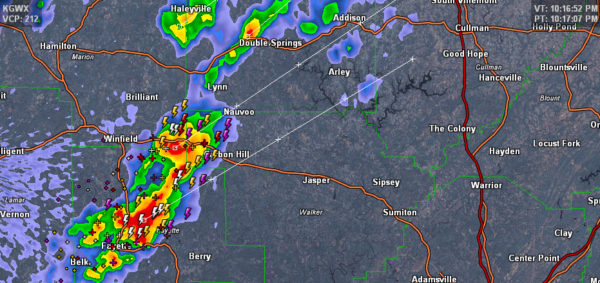
Two cores: one near Fayette and another just southeast of Winfield.
Lots of lightning and gusty winds with them. Can’t rule out some small hail too, but they are not severe and are not expected to be.
They are approaching Carbon Hill in Northwest Walker County and will be crossing I-22.
They will move toward Nauvoo in Walker County and into Winston County, passing near Arley.
Other heavy showers over eastern Marion and western Winston Counties may produce some lightning as well.
In Mississippi, the storms in front of the cold front extend from 20 miles west of West Point to west of Starkville to about 40 miles west of Philadelphia MS. The strongest storms are near Ackerman and passing south of Kosciusko MS.
Storms near Jackson are capable of producing nickle sized hail according to the NWS.
This activity will approach Pickens and southern Lamar Counties about 1130 p.m. Sumter county will see approaching storms between midnight and 1 a.m.
Storms should continue to weaken as we move into the early morning hours and severe weather is not expected.
Category: The Attic
About the Author (Author Profile)
Bill Murray is the President of The Weather Factory. He is the site's official weather historian and a weekend forecaster. He also anchors the site's severe weather coverage. Bill Murray is the proud holder of National Weather Association Digital Seal #0001 @wxhistorianSubscribe
If you enjoyed this article, subscribe to receive more just like it.


