

Strong Storms Over North Central Alabama
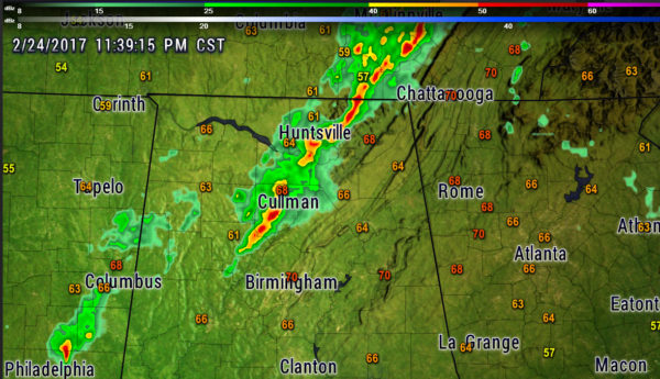
Strong storms are moving across northeastern Walker and Cullman Counties at this hour. They will bring heavy rain, lightning, 40 mph wind gusts and some small hail.
The storms will affect Blount County over the next 90 minutes. They should stay mainly north of Jefferson County.
Storms over eastern Mississippi have weakened considerably. The strongest remaining cells are approaching Macon, Mississippi and will impact Pickens County before 12:30 a.m.
Directly behind the front, winds have shifted to northwesterly at Winona and the the temperature has dropped to 56F.
The front will push into Alabama overnight and will out of East Alabama by just after sunrise.
Cooler and windy conditions will prevail on Saturday.
Category: The Attic
About the Author (Author Profile)
Bill Murray is the President of The Weather Factory. He is the site's official weather historian and a weekend forecaster. He also anchors the site's severe weather coverage. Bill Murray is the proud holder of National Weather Association Digital Seal #0001 @wxhistorianSubscribe
If you enjoyed this article, subscribe to receive more just like it.


