

The Historic February 25, 2015 North Central Alabama Snowstorm
February 20`5 was a cold month across Alabama with average temperatures for the month running some 8-10 degrees below normal. With all that cold, snow lovers would be licking their chops all month for that one really big snow.
In Birmingham, the week before Valentine’s Day was relatively balmy with highs in the 60s on the 7th, 8th, 9th, 11th and 14th. The highest temperature recorded during the month happened on the 8th, when it was 69F at the Birmingham Airport. Temperatures warmed to 62F on Saturday the 14th, but the cold air came in the next day, with highs in the lower 40s. Winter storm watches were posted on Sunday for Monday the 16th, but would be dropped for Central Alabama as temperatures were too warm and a cold rain was all that fell. The Northwest Corner of the state did see freezing rain during the afternoon of the 16th, with light accumulations across Franklin Colbert and Limestone Counties. Northwest Lauderdale County did see up to 1/4 inch of ice.
There were some icy patches on Tuesday morning, but things started to go downhill on Wednesday night as an arctic airmass invaded the area. A few snow showers dusted the Tennessee Valley. Huntsville picked up about one half inch of snow. A
hard freeze occurred that Thursday morning the 19th. It was 13F in Birmingham, 8 in Haleyville, 10 in Cullman and 19 in Tuscaloosa.
More wintry mix fell during the day on the 20th in areas north and east of Birmingham causing more travel headaches. Any overnight freezing rain led to problems in Northwest Alabama as well.
The weekend was a transition, with highs in the 50s and 60s, but the next threats were already on the radar, another wintry mix for Sunday night and Monday the 22nd and 23rd and a significant snow storm on Wednesday the 25th. The event on the 23rd turned out to be mainly a non-event except for some icy spots. Highway 69 between Jasper and Cullman was icy and dangerous.
Forecasts for Wednesday the 25th were pretty good. It was a classic Gulf of Mexico low snow situation. We forecast 2-4 inches across a wide area from Madison County to Shelby County, with isolated amounts to 8 inches. By that morning, it was obvious that a big snow was in store for North Alabama. 1-3″ was forecast across the Birmingham area with 3-6″ and isolated to 8″ were forecast for parts of North Central Alabama.
The event started as rain and sleet over West Alabama during the morning. But as the low intensified over the Gulf, dynamic cooing occurred, and rain changed to snow. The low caused upward motion that resulted in dynamic cooling as the air expanded and cooled. As the column cooled, precipitation changed to snow over North Central Alabama. Roads were impassable across Walker County by 2 p.m.
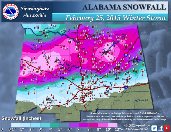
Snow finally arrived in Birmingham during the evening, but amounts in the Tuscaloosa, Birmingham and Anniston areas were generally around one half inch. Snowfall amounts tapered upwards rapidly across Lamar, Fayette, Walker, cullman, Blount, Etowah and DeKalb Counties into the 3-7 inch amount range. Maximum amounts around one foot fell across northern Lamar, Marion, and northwestern Winston Counties and also over Marshall County. Guin tallied the highest official amount with 12.5 inches. Haleyville measured 12 inches, Hamilton, Jasper and Sulligent all had 11″. Oneonta picked up 9 inches and Gadsden 7.5. Fayette recorded 7 inches. It would be one of the biggest snowstorm to affect North Central Alabama. For lots of other Central Alabamians, it was a big disappointing, cold rain.
Category: Met 101/Weather History
About the Author (Author Profile)
Bill Murray is the President of The Weather Factory. He is the site's official weather historian and a weekend forecaster. He also anchors the site's severe weather coverage. Bill Murray is the proud holder of National Weather Association Digital Seal #0001 @wxhistorianSubscribe
If you enjoyed this article, subscribe to receive more just like it.


