

Dry, Sunny Today, Rain Monday
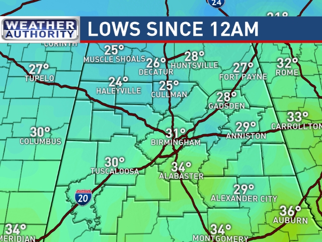
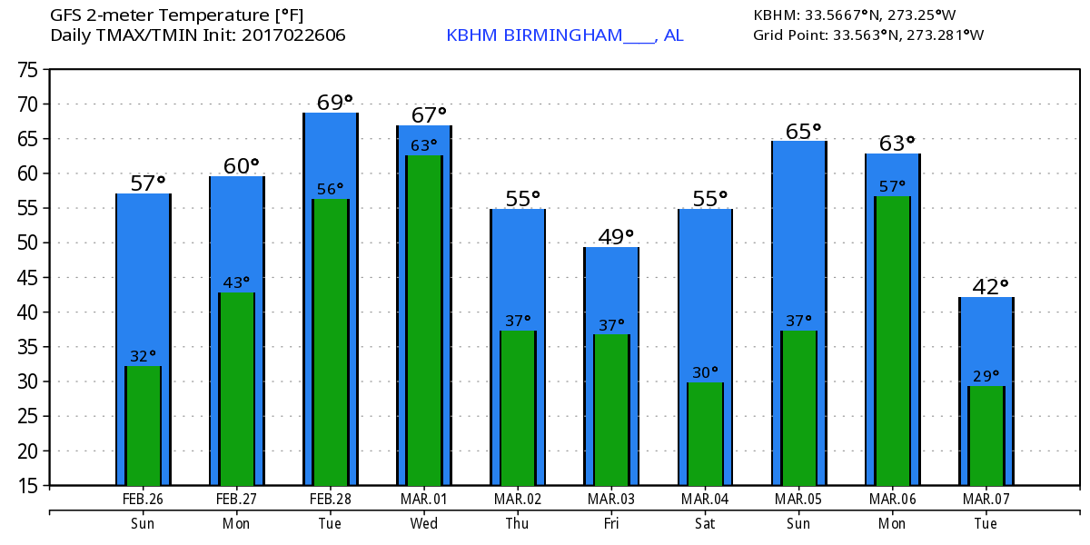
It is a chilly and crystal clear morning across Alabama. If you draw an east-west line through Prattville, just about every reporting station north of that line is at or below freezing. Our Skywatcher in Black Creek in Etowah County reported a low of 25 this morning with frost. Another Skywatcher in Centre reported 27. So if you are headed out early this morning you’re going to need a jacket. With an abundance of sunshine today, the afternoon highs should climb into the lower 60s making it a nearly perfect late February day.
For those who have the beach in their plans, dry and very nice weather continues today with slightly cooler temperatures. Warmer and unsettled weather returns to start the week. Click here to see the Beach Forecast Center page. Save Up To 25% on Spring Break Beach Vacations on the Alabama Gulf Coast with Brett/Robinson! The Beach Forecast is partially underwritten by the support of Brett/Robinson Vacation Rentals in Gulf Shores and Orange Beach. Click here to see Brett/Robinson’s best beach offers now!.
The next system is beginning to take shape with clouds expected to begin increasing late this afternoon and into the evening hours. Moisture throughout the column will increase tonight and Monday as the upper flow becomes southwesterly picking up moisture out of the Pacific. This will give a weak short wave what it needs to produce rains and thunderstorms from East Texas to the southern Appalachians during the day Monday. Clouds and rain should keep temperatures down a bit with highs comparable to those of today – in the lower 60s.
As the surface high slides eastward on Tuesday, the surface flow really comes around to the south allowing our highs to shoot back into the lower 70s. Without a good lifting mechanism, rain should become more showery in nature.
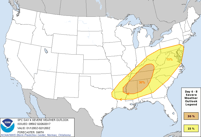
The big event appears likely to occur Wednesday just as we begin March and the start of the springtime tornado season for Alabama. A strong short wave will be moving across the Central Mississippi River Valley Wednesday as a surface low moves into the Great Lakes region. A cold front will trail southwestward from the low center into East Texas. SPC has raised the Day 4 likelihood of severe storms to the 30 percent category. CAPE values from the GFS have diminished a bit as max values approach 1000 j/kg. Shear values shown by the helicity charts are also down a bit. While these suggest that the tornado threat may be low, it does appear that a squall line with the potential of damaging wind will be the greatest threat. We’ll continue to watch the evolution of this system. With an abundance of moisture, it’s likely that rainfall amounts will be in the 1 to 2 inch range.
Thursday through Friday, the GFS depicts troughiness along the eastern US Coast keeping us cool but not excessively cold. Look for highs around the 60-degree mark. Ridging aloft slowly comes into play for the weekend as another surface high migrates across the Southeast US. This should provide a dry pattern for us with high temperatures climbing back toward 70 degrees. But Monday could be another stormy day for the Lower Mississippi River Valley with the approach of a strong upper trough. A surface low is forecast to move across the Ohio River Valley with another cold front approaching from the west. The pattern has all the earmarks for another round of severe storms, so it will bear watching – but we need to get through the one on Wednesday first!
The long range forecast, also known as voodoo country, looks cold as the GFS develops a deep trough along the East Coast and keeps it there for much of Week 2. This suggests a fairly long period of cold weather. Another strong trough is forecast to move across the Central US around the 13th of March, so the train of active systems keeps forecasters busy.
Enjoyed filling in for Meaghan Thomas last night on the 10 pm news. James Spann will be back with the next edition of the Weather Xtreme Video bright and early on Monday morning. Enjoy yet another very nice late February day. Please take the time over the few days to be sure your severe weather plans are up-to-date and that you have reliable methods for receiving weather warnings. Godspeed.
-Brian-
Category: Alabama's Weather
About the Author (Author Profile)
Brian Peters is one of the television meteorologists at ABC3340 in Birmingham and a retired NWS Warning Coordination Meteorologist. He handles the weekend Weather Xtreme Videos and forecast discussion and is the Webmaster for the popular WeatherBrains podcast.Subscribe
If you enjoyed this article, subscribe to receive more just like it.


