

Rain Continues To Push Across the Southern Half of Central Alabama At Midday
HOW’S THE WEATHER ACROSS CENTRAL ALABAMA AT MIDDAY
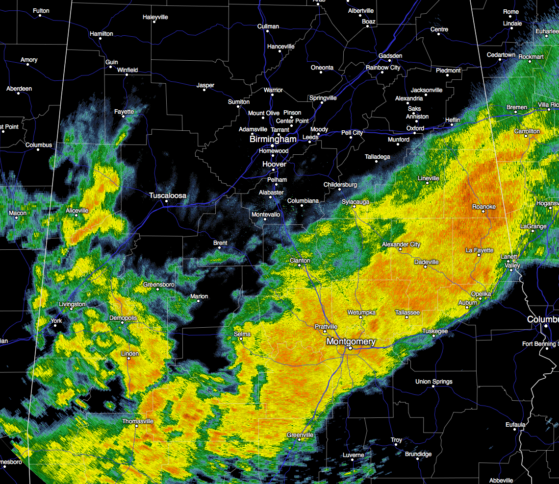
A line of light to moderate rainfall is stretching across the eastern parts of Central Alabama down to the south-central parts of the area, with scattered pockets of rain over the western parts of the state. There are no lightning strikes showing up at this time, as this is just a good soaking rain where it is falling. You can tell where the rain has fallen and where it hasn’t due to the difference in temperatures across the area.
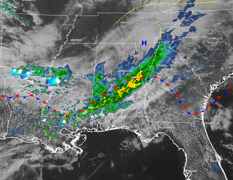
Back to our west, thunderstorms are occurring over parts of west-central Mississippi back into the southern parts of Arkansas and the northern parts of Louisiana. A few scattered showers and thunderstorms have formed along the southern parts of Mississippi and the eastern parts of Louisiana. A few severe thunderstorm warnings are currently in effect in southern Louisiana, mostly for damaging wind and quarter-size hail. Most of all of the activity is lined up along a stationary front that will turn into a warm front later tonight.
TEMPERATURES ACROSS CENTRAL ALABAMA
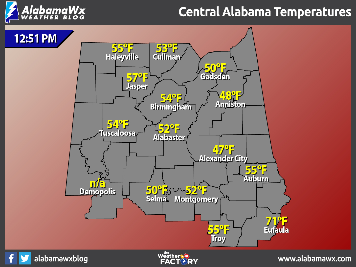
At 12:51 PM, temperatures are ranging from the upper 40s in the northeastern parts of Central Alabama, to the lower 70s in the southeast. Much of Central Alabama is in the lower to mid 50s. The warm spot is currently Eufaula at 71ºF, with the cool spot being Alexander City at 47ºF.
WHAT TO EXPECT FOR THE REST OF TODAY
Skies should remain mainly cloudy throughout the remainder of the day and into the evening hours tonight. Shower chances will continue mainly for locations south of the I-20 and I-20/59 corridors, but a few passing showers are possible just north of that. There will be a big temperature difference across the area with mid 50s to the lower 60s for most locations, with a few spots in the southeastern locations reaching the lower 70s. A few spots in the northeastern corner of the area could stay in the upper 40s to the lower 50s.
A warm front will move to the north across Central Alabama during the evening and overnight hours, allowing for dewpoints to increase. A risk for showers will continue for tonight, with the better chances being over the northern parts of the area. Overnight lows will be in the lower 50s to the lower 60s.
WHAT TO EXPECT ON TUESDAY
With a southerly low-level flow over Central Alabama, temperatures will be quite warm and a risk of scattered showers and a few isolated thunderstorms will continue through the day on Tuesday. The better rain chances will be over the northern half of the area, especially for the extreme northern locations in Central Alabama. Any severe weather risks will stay out of the area, and any thunder will occur north of a line from Tuscaloosa to Birmingham to Gadsden. Most of the activity will start during midday through the afternoon hours during the main heating of the day when the atmosphere destabilizes. Afternoon highs will be in the mid 70s to the low 80s across Central Alabama from north to south. Things seem to quiet down for the evening and rainfall should come to an end for most of the area, but patchy dense fog could form especially in the southeastern part of the area. Overnight lows will be in the mid 60s across the area.
WHAT TO EXPECT AT THE BEACH
For a detailed look at the weather from Fort Morgan over to Panama City Beach, click here to see a on our Beach Forecast Center page. Save Up To 25% on Spring Break Beach Vacations on the Alabama Gulf Coast with Brett/Robinson! The Beach Forecast is partially underwritten by the support of Brett/Robinson Vacation Rentals in Gulf Shores and Orange Beach. Click here to see Brett/Robinson’s best beach offers now!.
CLIMATOLOGY AND RECORDS FOR BIRMINGHAM
The normal high for February 27th is 62ºF, while the normal low is 38ºF. The record high for today was set back in 1962 at 82ºF. The record low was set back in 1963 at 15ºF.
TODAY IN WEATHER HISTORY
February 27, 1717: What was perhaps the greatest snow in New England history commenced on this date. During a ten day period a series of four snowstorms dumped three feet of snow upon Boston, and the city was snowbound for two weeks. Up to six feet of snow was reported farther to the north, and drifts covered many one story homes.
WEATHERBRAINS
On tonight’s show, the panel will take on an important issue: should private weather forecasting firms be able to issue specialized warnings that enhance or in some cases conflict with official National Weather Service warnings. You can catch this week’s show on these outlets:
James Spann 24/7 channel on cable or over the air on the dot 2 feed
Big Brains Media website
WeatherBrains website
Subscribe to the podcast on iTunes
THE BLOG IS ON SOCIAL MEDIA
@AlabamaWxBlog on Facebook
@AlabamaWxBlog on Twitter
WANT TO ADVERTISE ON THE ALABAMAWX WEATHER BLOG
Deliver your message to a highly engaged audience by advertising on the newly reformatted AlabamaWX.com website. The site enjoyed 10.2 MILLION page views in the past 12 months. Don’t miss out! We can customize a creative, flexible and affordable package that will suit your organization’s needs. Contact Bill Murray, at (205) 687-0782.
Category: Alabama's Weather
About the Author (Author Profile)
Scott Martin is an operational meteorologist, professional graphic artist, musician, husband, and father. Not only is Scott a member of the National Weather Association, but he is also the Central Alabama Chapter of the NWA president. Scott is also the co-founder of Racecast Weather, which provides forecasts for many racing series across the USA. He also supplies forecasts for the BassMaster Elite Series events including the BassMaster Classic.Subscribe
If you enjoyed this article, subscribe to receive more just like it.


