

Severe Storms Possible Across Alabama Tomorrow
RADAR CHECK: A band of showers persists across far North Alabama this afternoon… but much of the state is dry, humid, and very mild with temperatures up in the low 70s in many places.
NORTHWEST OF ALABAMA: A significant severe weather event will unfold tonight; a “moderate” severe weather risk is now up for parts of Missouri, Illinois, Indiana, Kentucky, and Ohio. Severe storms are possible in the broader zone from near Shreveport to Cleveland and Pittsburgh.
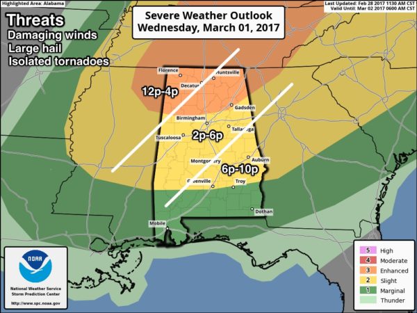
ALABAMA TOMORROW: SPC has trimmed the “enhanced” risk of severe storms a bit… it now includes the northern third of the state. The standard “slight” risk extends down to Grove Hill, Greenville, and Eufaula, and a “marginal” risk is up for far South Alabama.
The primary surface low will be far north of here, near Detroit tomorrow, but the trailing cold front will have decent upper support and strong wind fields. In addition, the air over Alabama will be pretty unstable by afternoon, with surface based CAPE values over 1,500 j/kg.
TIMING: There is a chance that severe storms could clip the northwest corner of Alabama early tomorrow morning (left over activity from tonight)… these storms could impact places like Muscle Shoals between 4 and 8 a.m. But, the main threat from the cold front will come later in the day. For most of North/Central Alabama, the core threat comes between 2:00 and 6:00 p.m.
THREATS: The main issue will be from strong, potentially damaging straight line winds. Large hail is possible with the stronger storms as well. An isolated tornado is possible, not especially likely based on the projected wind profiles.
RAIN: Rain amounts of around 1/2″ are expected; no flooding issues.
The line of storms will exit the state quickly tomorrow evening as the front moves on through.
THURSDAY/FRIDAY: The weather will feature sunny cool days and clear cold nights. Highs between 58 and 62… lows well down in the 30s early Friday morning.
THE WEEKEND: A morning freeze is likely early Saturday, with temperatures in the 28-32 degree range. Then, the weekend stays dry with a slow warming trend. The high Saturday will be in the low 60s, followed by upper 60s Sunday.
NEXT WEEK: Monday will be dry and pleasant, but rain will likely push into the state by Tuesday afternoon and Tuesday night ahead of a cold front. For now it doesn’t look like a severe weather threat… then cooler and drier air will settle in for the latter half of the week. See the Weather Xtreme video for maps, gprahics, and more details.
Click here to see the Beach Forecast Center page. Save Up To 25% on Spring Break Beach Vacations on the Alabama Gulf Coast with Brett/Robinson! The Beach Forecast is partially underwritten by the support of Brett/Robinson Vacation Rentals in Gulf Shores and Orange Beach. Click here to see Brett/Robinson’s best beach offers now!.
CONNECT: You can find me on all of the major social networks…
Facebook
Twitter
Google Plus
Instagram
Pinterest
Snapchat: spannwx
WEATHER BRAINS: Don’t forget you can listen to our weekly 90 minute netcast anytime on the web, or on iTunes. This is the show all about weather featuring many familiar voices, including our meteorologists here at ABC 33/40.
Look for the next Weather Xtreme video here by 7:00 a.m. tomorrow…
Category: Alabama's Weather
About the Author (Author Profile)
James Spann is one of the most recognized and trusted television meteorologists in the industry. He holds the AMS CCM designation and television seals from the AMS and NWA. He is a past winner of the Broadcast Meteorologist of the Year from both professional organizations.Subscribe
If you enjoyed this article, subscribe to receive more just like it.


