

A Pretty Nice Midday Across Central Alabama… Gotta Love It!
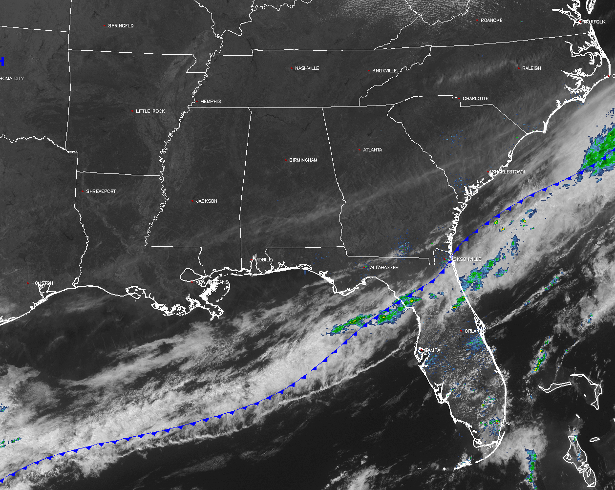
Sunny skies and cooler conditions exist across Central Alabama at midday, a day after much warmer temperatures and strong to severe thunderstorms occurred across the area. Skies are sunny across not only much of the state, but for much of the southeast. The cold front that brought the thunderstorms to the state yesterday is currently draped just off the Atlantic Coast, across the Florida Peninsula, and back over the waters of the northern Gulf of Mexico. The only rain activity in the southeast is located along and just ahead of the cold front in Florida.
For the rest of the day, the sun will be out in full force, and afternoon highs will make it into the upper 50s to the mid 60s across Central Alabama from north to south. The high for Birmingham should top out at 61ºF. Clear skies and pretty chilly temperatures for the evening and overnight hours tonight, with lows dipping into the mid to upper 30s. A few colder spots could drop below freezing, or even into the upper 20s.
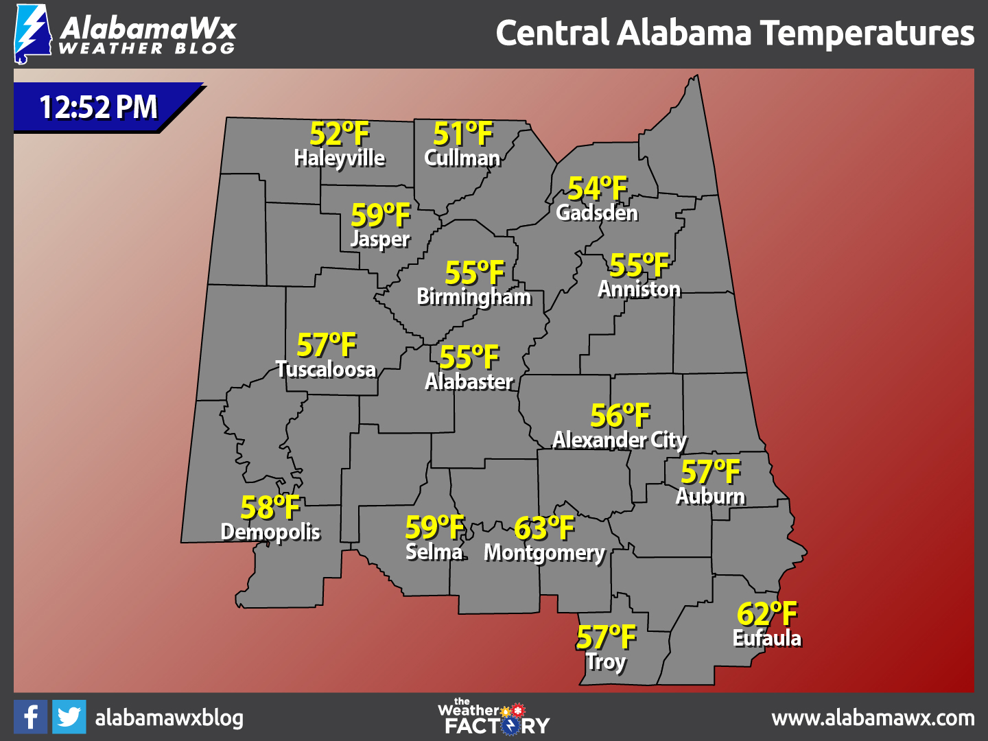
TEMPERATURES ACROSS CENTRAL ALABAMA
At 12:52 PM, temperatures are ranging from the lower 50s in the northern parts of Central Alabama, to the lower 60s to the south. The warm spot is currently Montgomery at 63ºF, with the cool spot is Cullman at 51ºF.
A FINE FRIDAY INDEED
Another beautiful day ahead for Central Alabama… Skies will be mostly sunny, with temperatures being just a touch cooler than today. Afternoon highs will be in the mid 50s to the mid 60s across the area from north to south, typical temperatures for this time of the year.
WHAT TO EXPECT AT THE BEACH
For a detailed look at the weather from Fort Morgan over to Panama City Beach, click here to see a on our Beach Forecast Center page. Save Up To 25% on Spring Break Beach Vacations on the Alabama Gulf Coast with Brett/Robinson! The Beach Forecast is partially underwritten by the support of Brett/Robinson Vacation Rentals in Gulf Shores and Orange Beach. Click here to see Brett/Robinson’s best beach offers now!.
CLIMATOLOGY AND RECORDS FOR BIRMINGHAM
The normal high for March 2nd is 63ºF, while the normal low is 39ºF. The record high for today was set back in 1976 at 83ºF. The record low was set back in 1980 at 15ºF.
TODAY IN WEATHER HISTORY
March 2, 1988: Thunderstorms produced severe weather in the south central U.S. A tornado at Baton Rouge LA injured two persons, and another tornado caused five million dollars damage at the airport in Lafayette LA.
WEATHERBRAINS
On this week’s show, the panel took on an important issue: should private weather forecasting firms be able to issue specialized warnings that enhance or in some cases conflict with official National Weather Service warnings. You can catch this week’s show on these outlets:
WeatherBrains website
Subscribe to the podcast on iTunes
THE BLOG IS ON SOCIAL MEDIA
@AlabamaWxBlog on Facebook
@AlabamaWxBlog on Twitter
WANT TO ADVERTISE ON THE ALABAMAWX WEATHER BLOG
Deliver your message to a highly engaged audience by advertising on the newly reformatted AlabamaWX.com website. The site enjoyed 10.2 MILLION page views in the past 12 months. Don’t miss out! We can customize a creative, flexible and affordable package that will suit your organization’s needs. Contact Bill Murray, at (205) 687-0782.
Category: Alabama's Weather, ALL POSTS
About the Author (Author Profile)
Scott Martin is an operational meteorologist, professional graphic artist, musician, husband, and father. Not only is Scott a member of the National Weather Association, but he is also the Central Alabama Chapter of the NWA president. Scott is also the co-founder of Racecast Weather, which provides forecasts for many racing series across the USA. He also supplies forecasts for the BassMaster Elite Series events including the BassMaster Classic.Subscribe
If you enjoyed this article, subscribe to receive more just like it.


