

Rain/Storms Move Into Alabama Tomorrow
MILD MONDAY: Temperatures are mostly in the low 70s across the great state of Alabama this afternoon with a mix of sun and clouds; nothing on the radar as of 3:15 p.m. We will maintain the chance of a few isolated showers tonight, but the main action will be well to the northwest of Alabama, where most of Missouri and parts of the adjacent states are under an “enhanced” risk of severe storms. Tornado watches are already in effect from Missouri north to Minnesota.
STORMY TUESDAY: A deep surface low will move into Canada, but the trailing cold front will creep into Alabama tomorrow bringing showers and thunderstorms. With the surface low and main wind fields well to the north, we don’t anticipate a big severe weather problem, but SPC has pulled a “marginal” risk into West and North Alabama…
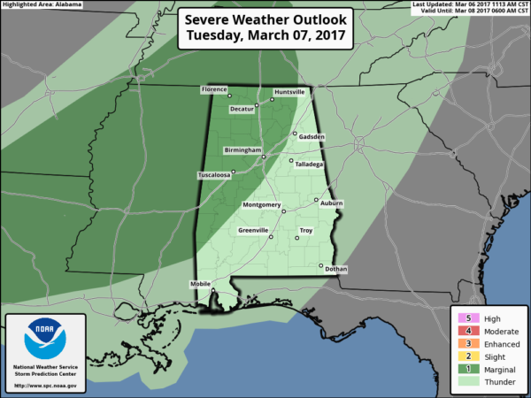
Thunderstorms tomorrow afternoon could produce hail and strong gusty winds; main window for the heavier storms will come from 12:00 noon to 8:00 p.m. Rain amounts of at least 1/2 inch are likely; a few spots could see up to one inch.
WEDNESDAY/THURSDAY: These two days will be dry with cool nights and pleasant afternoons… the high Wednesday will be close to 70, followed by mid 70s Thursday. We do note Thursday morning will be chilly with a low in the upper 30s in many places.
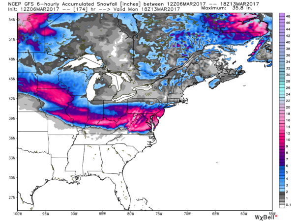
FRIDAY AND THE WEEKEND: A cold front will approach Alabama from the north Friday, and with moisture levels rising we could see a few showers, and possibly a thunderstorm. The front will hang up over Tennessee, and move a little northward Saturday in response to a surface low forming over Arkansas. This puts Alabama in the “warm sector” of the new system Saturday, opening the door for strong, maybe severe thunderstorms. SPC in their “Day 6” outlook for Saturday has a risk defined already for the northwest corner of Alabama. Just a little too early to determine if severe storms will be an issue; the latest GFS suggests instability values won’t be all that high, which might mitigate a severe weather problem. We will have much better clarity after tomorrow’s event; you know we like to take them one at a time.
Sunday will feature a clearing sky, and the weather turns much cooler with a high between 58 and 61 degrees.
MARCH SNOW: Global models are hinting a pretty good March snow event could unfold this weekend north of Alabama… travelers beware…
NEXT WEEK: A very active March pattern continues; another round of showers and storms seems likely Monday night with another cold front approaching from the west. And, yet another system shows up later in the week. See the Weather Xtreme video for maps, graphics, and more details.
Click here to see the Beach Forecast Center page. Save Up To 25% on Spring Break Beach Vacations on the Alabama Gulf Coast with Brett/Robinson! The Beach Forecast is partially underwritten by the support of Brett/Robinson Vacation Rentals in Gulf Shores and Orange Beach. Click here to see Brett/Robinson’s best beach offers now!.
WEATHER BRAINS: Don’t forget you can listen to our weekly 90 minute netcast anytime on the web, or on iTunes. This is the show all about weather featuring many familiar voices, including our meteorologists here at ABC 33/40. We will produce this week’s show tonight at 8:30 CT… you can watch it live here.
CONNECT: You can find me on all of the major social networks…
Facebook
Twitter
Google Plus
Instagram
Pinterest
Snapchat: spannwx
I enjoyed seeing students today at American Christian Academy in Tuscaloosa… and Greystone Elementary in Hoover… be looking for them on the Pepsi KIDCAM today at 5:00 and 6:00 on ABC 33/40 News! The next Weather Xtreme video will be posted here by 7:00 a.m. tomorrow…
Category: Alabama's Weather, ALL POSTS
About the Author (Author Profile)
James Spann is one of the most recognized and trusted television meteorologists in the industry. He holds the AMS CCM designation and television seals from the AMS and NWA. He is a past winner of the Broadcast Meteorologist of the Year from both professional organizations.Subscribe
If you enjoyed this article, subscribe to receive more just like it.


