

Noon Update and a Look at Potential Snow Amounts for the Tennessee Valley
Last night’s showers and storms are a distant memory, at least according to regional radars. But some folks across Central Alabama are cleaning up from wind damage that occurred as the storms surged past I-20. The system developed into a mesoscale convective system with its own sustaining cold pool aloft that produced fairly widespread 50-60 mph winds.
The wind gusted to 56 mph at the Birmingham Airport at 2:36 a.m. That prompted the first of a second wave of severe thunderstorm warnings as the line surged south. Winds were estimated to 60 mph at the Shelby County Airport. And winds gusted to 66 mph at the Sylacauga automated weather station.
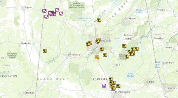
There were 31 reports of wind damage across the state, generally aligned north to south along I-65. Some places that were affected:
…Trees down on apartment complex near Huntsville
…Trees down in Bangor in Blount County
…Trees down in Concord and Pleasant Grove in Jefferson County
…Trees down near Chelsea in Shelby County
…Trees down on the Timber Ridge GC in Talladega
…Numerous buildings sustained wind damage in downtown Wetumpka
…Trees down in Prattville, Millbrook and Deatsville
Earlier, there were a few reports of large hail in Northwest Alabama, including a couple of 1.75 inch diameter reports in Marion County. That is golf ball size. Hail covered the ground west of Hamilton for a time.
The prefrontal trough blew through right behind the line of storms, which has dissipated this morning.
Now the cold front is making it’s southward sojourn, reaching I-20 as you eat your lunch. It’s been a nice mid to late morning with a good supply of sunshine over the northern half of the state and temperatures in the upper 60s to near 70F. Behind the front, temps are in the upper 50s to near 60F. Dewpoints fall from the upper 50s to near 50F and then into the 30s quickly thereafter. Throw in a light northerly breeze and it will feel refreshing this afternoon and evening.
Expect mid to upper 30s tonight with partly cloudy skies.
Clouds will increase on Sunday as our split jetstream tries to come back into phase over Alabama. The converging streams of air will increase upper level winds over the state, aiding lift and combining with a passing mid-level disturbance and lows tracking along the front to the south to produce a cold rain Saturday night. As colder air filters in, rain will change to a wintry mix of snow and ice for the Tennessee Valley.
Here are projected snow depths from the morning run of the GFS for 7 a.m. CDT Sunday:
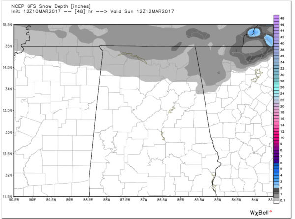
I think this is a good projection of potential snow amounts across North Alabama. Around one half inch across northern parts of Lauderdale, Limestone, Madison and Jackson Counties with one inch possible at higher elevations. A dusting could extend down through Franklin, Lawrence, Morgan, northern Cullman, Marshall, DeKalb and Cherokee Counties.
The ground will be warm, but there could be some travel problems north of US-72 early Sunday morning.
Rainfall amounts with the weekend system will total less than one quarter inch. There will be no severe weather, just a cold rain.
A reinforcing shot of cold air will arrive Tuesday accompanied by a few light showers. Expect a widespread freeze Wednesday morning with temperatures struggling to get out of the 40s during the day. Look for another 0.75 inches of rain next Saturday the 18th.
More rain falls on the 25th and amounts will be a little more generous, around 1-2 inches. 16 day totals off the GFS are hovering around 2-4 inches across North and Central Alabama.
I just don’t see any severe weather through the next two weeks for Alabama as we stay in a cold pattern.
Category: Alabama's Weather, ALL POSTS
About the Author (Author Profile)
Bill Murray is the President of The Weather Factory. He is the site's official weather historian and a weekend forecaster. He also anchors the site's severe weather coverage. Bill Murray is the proud holder of National Weather Association Digital Seal #0001 @wxhistorianSubscribe
If you enjoyed this article, subscribe to receive more just like it.


