

Late Evening Look at the Alabama Weather Situation – 10 p.m. Friday
Drier and colder air is filtering into the state behind a cold front, and lows will fall into the lower and middle 30s Saturday morning. Frost will occur in some of the protected valleys of North Alabama early in the morning. But even bigger cold is ahead with a significant freeze Tuesday night and again Wednesday night.
PRECIPITATION TYPE AND AMOUNTS: A few light showers break out during the afternoon tomorrow. Amounts will be light and coverage will be about 40%. A steady cold rain will break out between 6 p.m. and midnight Saturday night, somewhere around the I-20 Corridor. Rainfall amounts will be between a quarter and one half inch in the main rain area, with lesser amounts to the north and south.
After midnight, a wintry mix will develop over the Tennessee Valley with freezing rain and snow mixing. Accumulations in Alabama should be light, although it doesn’t take much freezing rain to cause problems. Our ground temps have been so warm, which will help, but bridges and overpasses could be treacherous over counties along and north of the Tennessee River.
We could see one tenth of an inch of ice accumulating on Lookout Mountain in Northeast Alabama as well as northern Jackson County. A dusting of snow could fall across the norther portion of Lauderdale, Limestone, Madison and Jackson Counties. South of there, just a cold rain.
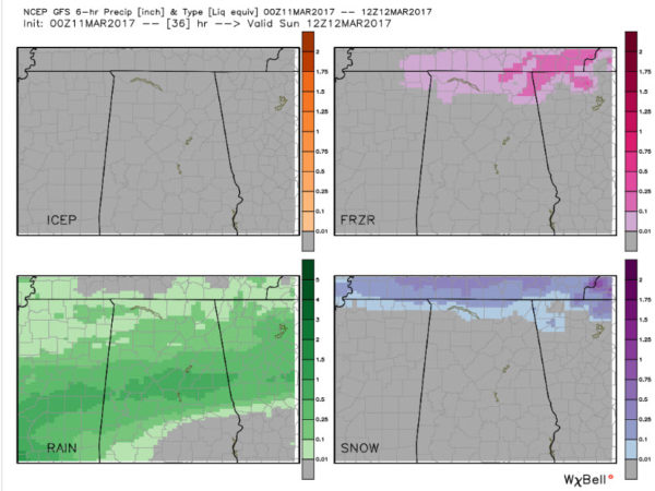
Accumulated precipitation by precipitation type Saturday night according to the GFS model.
WINTER STORM WARNINGS: Heavy snow is expected tonight over the Great Smoky Mountains of eastern Tennessee and western North Carolina. 6-8 inches will fall above 5,000 feet, with 4-6 inches in places like Asheville and Gatlinburg.
SUNDAY should feature colder and clearing conditions. A breezy northeast wind will make it feel even cooler.
TEMPERATURES: Highs Saturday will be in the lower 50s over the north with 56-60F over north Central sections. Lows Saturday night will be at or below freezing over the Tennessee Valley, with lower 30s at Hamilton and Cullman. Middle 30s to near 40F will prevail in the I-20/59 Corridors.
DST: Don’t forget to spring forward Sunday morning at 2 a.m. as Daylight Saving Time starts again.
Category: Alabama's Weather, ALL POSTS
About the Author (Author Profile)
Bill Murray is the President of The Weather Factory. He is the site's official weather historian and a weekend forecaster. He also anchors the site's severe weather coverage. Bill Murray is the proud holder of National Weather Association Digital Seal #0001 @wxhistorianSubscribe
If you enjoyed this article, subscribe to receive more just like it.


