

Dry, Wet, Dry Again and Cold
Hopefully you have remembered to set your clocks ahead either last night or this morning as we begin Daylight Saving Time.
Rain moved into Central Alabama yesterday morning quite a bit faster than I expected it would, so we ended up with a rather wet day. Total rainfall at my station in Helena was 92 hundredths of an inch which will certainly contribute to lowering the drought impact. Rain has moved out of Central Alabama though there could be a little lingering drizzle until mid morning. Some sunshine will return for the afternoon with highs mainly in the middle and upper 50s – near 60 at Montgomery.

For a detailed look at the weather from Fort Morgan to Panama City Beach, you can click here to see the Beach Forecast Center page. Save Up To 25% on Spring Break Beach Vacations on the Alabama Gulf Coast with Brett/Robinson! The Beach Forecast is partially underwritten by the support of Brett/Robinson Vacation Rentals in Gulf Shores and Orange Beach. Click here to see Brett/Robinson’s best beach offers now!
The primary models, ECMWF and GFS, are in reasonably close agreement for much of the week ahead, but do diverge somewhat as we head into next weekend. The weak short wave trough moving through the Southeast US continues to make its way east while a weak surface low tracks along and just south of the Gulf Coast. So today should be dry as we wait on the approach of another trough on Monday.
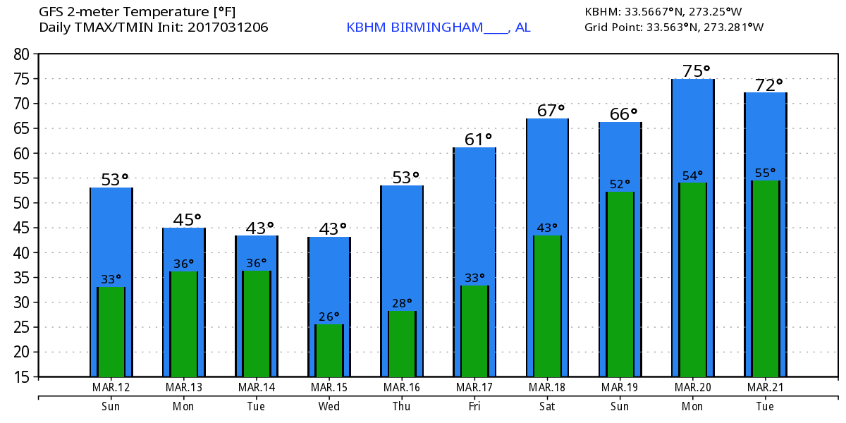
The trough Monday is poised over Arkansas and should move through and across the Southeast US Monday afternoon and very early Tuesday. This will set us up for another round of rainfall with rain occurring primarily Monday afternoon and evening. Rainfall amounts do not appear to be particularly heavy with somewhat limited moisture for this system to work on. The trough Monday afternoon will dig into the long wave trough over the eastern seaboard of the US, so it is going to get cold. At the surface a large high pressure system will be over Minnesota with a northerly flow straight out of eastern Canada and the snow field up there. GFS MOS guidance suggests a high around 50 degrees, but I’m doubtful that we get that warm. With the system blasting through here Monday afternoon and evening, temperatures on Tuesday are not likely to climb out of the 40s. In fact, we may see very little diurnal range to the highs and lows for that day, so Tuesday could be a somewhat bitter cold day.
This weather system creates quite the nor’easter for the Mid-Atlantic State into New England for Tuesday with the GFS pegging the surface low around 984 millibars. Much of the area from New York, Pennsylvania, Maryland, and Delaware northeastward across all of New England is now under winter storm watches primarily for Tuesday with snow amounts running as much as 18 to 24 inches. There is even a blizzard watch for much of the coastal area from New York City to Boston.
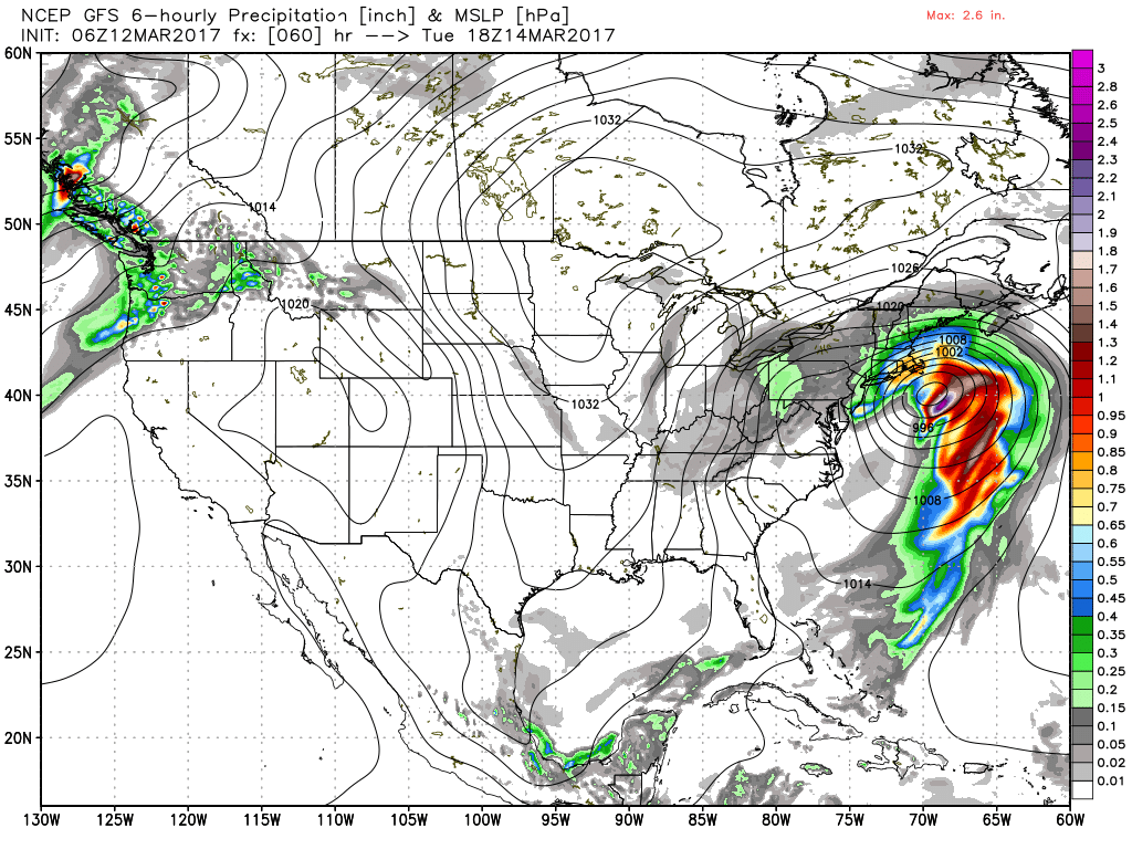
Back in Alabama, there is a small risk for some wrap around precipitation on Tuesday that could come in the form of snow flurries as the precipitation comes to an end along the northern most counties. Wrap around situations rarely provide us with any significant snow events.
The upper trough sticks with us Wednesday and Thursday, so it will remain cold. Looks like lows will be in the 20s. I expect to see a freeze warning issued by the National Weather Service offices for a fairly sizable chunk of Alabama at some point in the next couple of days.
As we get to Friday, the models diverge, and I’m favoring the ECMWF solution. Friday we come under a weak ridge briefly before the flow goes back to northwesterly on Saturday. The GFS upper air charts look pretty good, but the GFS keeps the front from coming through Alabama. This does not seem to fit very well with the upper air flow which certainly seems to support the front pushing through the Southeast US. The GFS MOS even has a high of 76 on Sunday which seems totally out of line with the pattern it is suggesting. So I’l stick with the European for now.
The weather pattern remains active for the long range. The upper flow stays northwesterly through about the 23rd of March. There are a couple of short waves moving through the ridge around the 25th of March that may produce a round of wet weather. But by the 27th of March the GFS is projecting a substantial ridge over Mexico with a closed contour of 5910 meters and a ridge axis along the eastern slope of the Rockies. Almost looks too anomalous to be true, but we’ll see!
James Spann will be back with the next edition of the Weather Xtreme Video first thing on Monday morning. Enjoy the dry day and perhaps start taking whatever precautions you may need for the extended cold weather from Tuesday through Thursday. Have a great day and Godspeed.
-Brian-
Category: Alabama's Weather, ALL POSTS
About the Author (Author Profile)
Brian Peters is one of the television meteorologists at ABC3340 in Birmingham and a retired NWS Warning Coordination Meteorologist. He handles the weekend Weather Xtreme Videos and forecast discussion and is the Webmaster for the popular WeatherBrains podcast.Subscribe
If you enjoyed this article, subscribe to receive more just like it.


