

The Big One in 1993; Another “Big One” Brewing for the Northeast Corridor
On this date in 1993, we were waiting and watching as one of the most incredible and improbable winter storms in American history was taking shape in the Gulf of Mexico. Low pressure was forming along a stationary front near the Texas coast. A powerful jet stream on the eastern side of a strong upper level trough. Strong thunderstorms developed over the Gulf of Mexico during the day, allowing the low to rapidly strengthen. Cold air was drawn south by the powerful low and combined with the abundant moisture to create a record snowstorm for parts of Alabama and much of the eastern United States.
MILESTONE: The Superstorm represented a milestone in weather forecasting as meteorologists were able to predict accurately a full five days out that a significant snowstorm was going to affect a large part of the eastern United States. I worked at Channel 42 then as the weekend weather forecaster, and I went in that Monday night the 8th to look at dot matrix output from our weather provider. The Extended Forecast Discussion from the NMC that Monday called for “the threat of late winter heavy snowfall from the southern Appalachians/eastern Tennessee Valley northeastward through the major metro areas from D.C. to Boston”
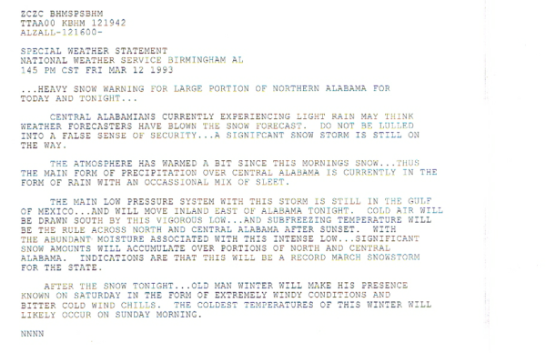
WINTRY BLAST: By Wednesday morning, the NWS in Birmingham was issuing special weather statements highlighting the threat for Friday night and Saturday. Here is the text of their product from 1030 a.m. CST that Wednesday March 10th.
By Wednesday night, our mouths were agape at output from the LFM model that showed a hurricane strength low in the Gulf with Arctic air flooding south into Alabama. We know what happened from there.
Winter storm watches were issued Thursday afternoon for Alabama. A winter storm warning was issued for the Tennessee Valley Friday morning and the winter storm watch was continued for the remainder of North and Central Alabama for areas north of a line from Demopolis to Clanton to Talladega to Heflin. So there was still uncertainty about what would happen. I was frantically warning hotels in our area to lay in food stores for five days, top of diesel for generators and call in staff. They looked at me like I was crazy. It had been 75F on Monday!
School officials were cautioned by the NWS to consider an early release in a mid-morning special weather statement. Once the morning model data was in, a heavy snow warning was issued for all of North Alabama. Counties down to Sumter, Greene, Hale, Perry, Chilton, Talladega, Calhoun and Cleburne were included in the warning.
Wind advisory and high wind advisories were added later in the evening and the heavy snow warning was expanded to Southwest Alabama before midnight. Even the Florida Panhandle was included in a snow advisory issued by 1 a.m. and Southeast Alabama was added later.
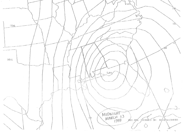
I love this graphic J.B. Elliott saved from his printer that Saturday morning. It is the surface pressures from his weather provider at midnight CST that early Saturday morning, showing the rapidly deepening low near Apalachicola with a pressure of 988 millibars. A 12 foot storm surge was impacting the West Coast of Florida along with a devastating tornado outbreak.
ANOTHER BIG ONE: Another “big one” is brewing even as we speak. Another big storm for the East Coast.
While this one won’t be “the big one” like 1993, it still will bring some impressive snow totals to the Northeast U.S. starting tomorrow night.
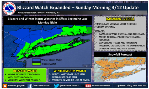
A blizzard watch is in effect for coastal New Jersey, New York, Connecticut, Rhode Island and Massachusetts ahead of the big storm. 12-18 inches of snow is expected in New York City beginning late Monday night through Tuesday evening.
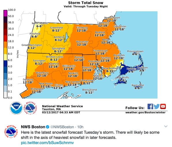
Boston is expecting less than 6 inches, but winds of 20-30 mph with gusts to 55 mph and visibilities ¼ mile or less in snow or blowing snow will create blizzard conditions. The central pressure in the surface low behind the big nor’easter could reach 988 mb, about the strength of a minimal hurricane. For comparisons, the Superstorm in 1993 had a pressure of around 967 millibars.
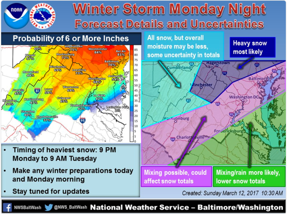
Washington D.C. is calling for five inches or more, with a little more uncertainty in their forecast. They could get much more.
Category: ALL POSTS, Met 101/Weather History
About the Author (Author Profile)
Bill Murray is the President of The Weather Factory. He is the site's official weather historian and a weekend forecaster. He also anchors the site's severe weather coverage. Bill Murray is the proud holder of National Weather Association Digital Seal #0001 @wxhistorianSubscribe
If you enjoyed this article, subscribe to receive more just like it.


