

Strong Storms Far North Alabama This Evening
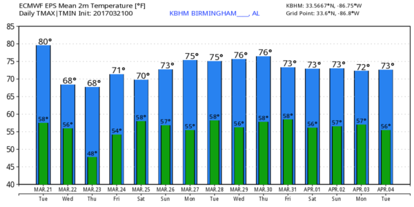
WARM MARCH AFTERNOON: Temperatures are mostly in the mid 80s across Alabama this afternoon; Birmingham reports 87 degrees at 3:00… within 3 degrees of the record high for March 21 of 90, set in 1907.
TO THE NORTH: Severe storms are forming along a surface boundary over Tennessee, and SPC has issued a severe thunderstorm watch for far North and Northeast Alabama until 10p CT…
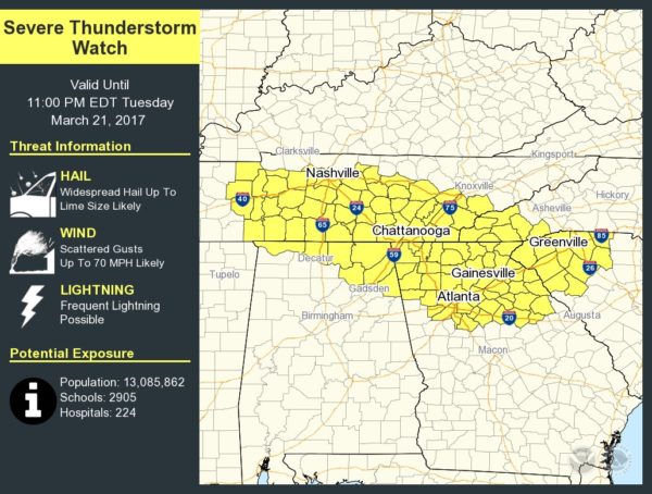
Storms over extreme North Alabama could produce large hail and damaging straight line winds this evening; the activity should stay north of a line from Russellville to Cullman to Gadsden. The main window for severe storms will come from 4:00 until 8:00 p.m.
Most of Alabama will be dry and mild tonight.
TOMORROW/THURSDAY: The surface front will sag southward, but with little upper support and limited moisture, looks like any showers on these two days will be few and far between. We will forecast a mix of sun and clouds both days with a cooling trend; the high tomorrow will be near 70, and then back in the mid 60s Thursday. The chance of any one spot getting wet each day is only about one in ten.
Friday looks dry and mild; the sky will be partly to mostly sunny with a high in the mid 70s.
UNSETTLED WEATHER FOR THE WEEKEND: A dynamic weather system will bring a chance of severe storms Friday to areas west of Alabama, including Dallas, Tulsa, Little Rock, and Shreveport, but it is expected to weaken a bit by the time it impacts our state over the weekend. A surface low will be Missouri Saturday, with moist, unstable air over Alabama. The GFS continues to trend slower, hinting that a decent part of the day Saturday could be dry before showers and storms arrive late in the day into Saturday night. We do note the European global model is faster, with storms moving into the state by mid-afternoon.
We will be much more specific about timing tomorrow after we get a few more model sets. Concerning the potential for severe weather, it looks like a rather marginal threat for Alabama at this point late Saturday afternoon and Saturday night. SPC has pulled our state out of their severe weather risk on the “Day 5” outlook, keeping the threat mainly over Mississippi. Again, we will be much more specific tomorrow.
Sunday will be mostly cloudy with a chance of showers and possibly a thunderstorm, but severe storms are not expected. Highs over the weekend will be in the 70s.
NEXT WEEK: We stay in moist, unstable air for the first half of the week, and a rather robust system shows up Thursday, and if the 12Z GFS were to verify we could have a severe weather threat statewide. Of course, that is out in voodoo land and the setup can easily change. See the Weather Xtreme video for maps, graphics, and more details.
Click here to see the Beach Forecast Center page. Save Up To 25% on Spring Break Beach Vacations on the Alabama Gulf Coast with Brett/Robinson! The Beach Forecast is partially underwritten by the support of Brett/Robinson Vacation Rentals in Gulf Shores and Orange Beach. Click here to see Brett/Robinson’s best beach offers now!.
STORM SPOTTER TRAINING: We will be on the road through early April offering free storm spotter classes. We need more trained spotters in Alabama; by attending you can make the severe weather warning process better. No need to register; just come with a curious mind. And, there is no age limit… kids that love weather will enjoy it. You will never look at a storm the same again. We are in Lineville this evening; training begins at 6:30 at the Clay County Farmers Market… and Thursday will be in Gardendale at 6:30 at the Gardendale Civic Center.
WEATHER BRAINS: Don’t forget you can listen to our weekly 90 minute netcast anytime on the web, or on iTunes. This is the show all about weather featuring many familiar voices, including our meteorologists here at ABC 33/40.
CONNECT: You can find me on all of the major social networks…
Facebook
Twitter
Google Plus
Instagram
Pinterest
Snapchat: spannwx
I enjoyed seeing the students today at Madison Academy and McElwain Christian Academy… be looking for them on the Pepsi KIDCAM today at 5:00 and 6:00 on ABC 33/40 News! The next Weather Xtreme video will be posted here by 7:00 a.m. tomorrow…
Category: Alabama's Weather, ALL POSTS
About the Author (Author Profile)
James Spann is one of the most recognized and trusted television meteorologists in the industry. He holds the AMS CCM designation and television seals from the AMS and NWA. He is a past winner of the Broadcast Meteorologist of the Year from both professional organizations.Subscribe
If you enjoyed this article, subscribe to receive more just like it.


