

Severe T-storm Warning Issued for Parts of Jackson & Madison Counties Until 5:30PM Expired
The National Weather Service in Huntsville Alabama has issued a
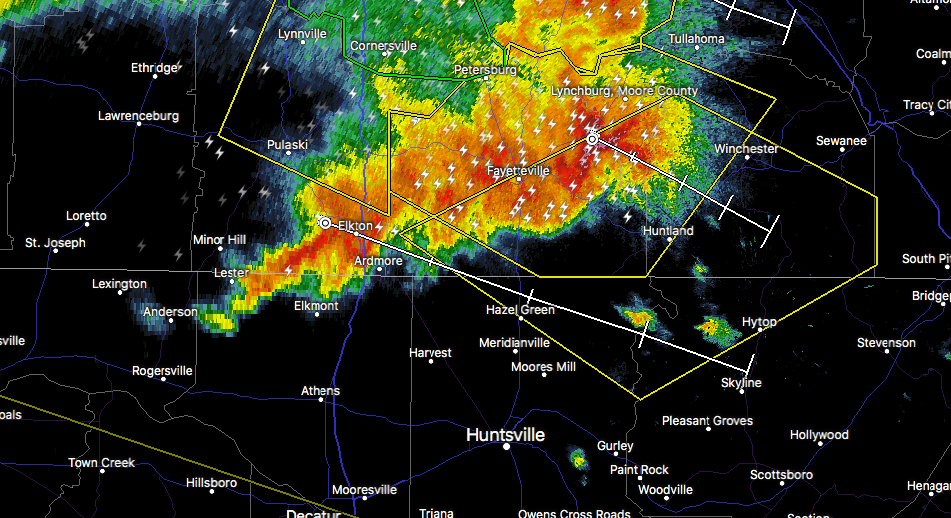
* Severe Thunderstorm Warning for…
Northwestern Jackson County in northeastern Alabama…
Northeastern Madison County in north central Alabama…
Southeastern Moore County in Middle Tennessee…
Southern Lincoln County in Middle Tennessee…
Franklin County in Middle Tennessee…
* Until 530 PM CDT
* At 456 PM CDT, severe thunderstorms were located along a line
extending from near Tims Ford Lake to 8 miles east of Ardmore,
moving southeast at 45 mph.
HAZARD…70 mph wind gusts and quarter size hail.
SOURCE…Radar indicated.
IMPACT…Hail damage to vehicles is expected. Expect considerable
tree damage. Wind damage is also likely to mobile homes,
roofs, and outbuildings.
* Locations impacted include…
Winchester, Fayetteville, Hazel Green, Decherd, Cowan, Huntland,
Tims Ford Lake, New Market, Anderson and Lincoln.
Category: ALL POSTS, Archived Warnings
About the Author (Author Profile)
Scott Martin is an operational meteorologist, professional graphic artist, musician, husband, and father. Not only is Scott a member of the National Weather Association, but he is also the Central Alabama Chapter of the NWA president. Scott is also the co-founder of Racecast Weather, which provides forecasts for many racing series across the USA. He also supplies forecasts for the BassMaster Elite Series events including the BassMaster Classic.Subscribe
If you enjoyed this article, subscribe to receive more just like it.


