

Latest On Our Weather Situation At 3:00PM

RADAR CHECK
Severe thunderstorms have now moved into the northwestern corner of the state, with other cells developing across parts of Central Alabama out ahead of that action. Already have had a few Severe Thunderstorm Warnings from across the area, ranging from pea-size hail in Warrior, to golf ball-size hail in Marshall County. All of these storms are pushing off to the northeast.

A Significant Weather Advisory was just issued for parts of Franklin County until 3:30PM for a strong thunderstorm near Red Bay, moving northeast at 35 mph. Penny size hail and winds in excess of 40 mph will be possible with this storm. Locations in the path are Russellville, Red Bay, Belgreen, Vina, Atwood, Rockwood, Pleasant Ridge, Dempsey, Isbell and Cedar Creek Reservoir.
Another Significant Weather Advisory was just issued for parts of Lauderdale County until 3:30PM for a strong thunderstorm near Killen, or 12 miles northeast of Florence, moving northeast at 30 mph. Penny size hail and winds in excess of 40 mph will be possible with
this storm. Locations in the path are Killen, Lexington, St. Joseph, Anderson, Green Hill, Center Star, Kingtown and Whitehead.
SEVERE OUTLOOK FROM THE STORM PREDICTION CENTER
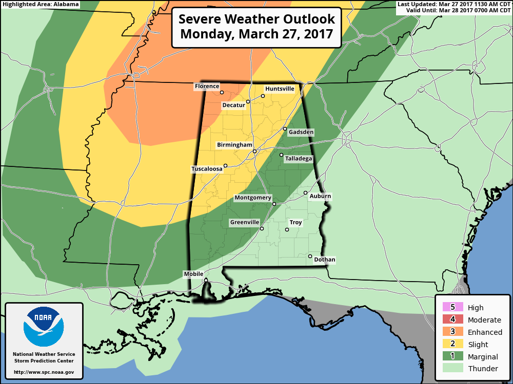
The last update from the SPC has the northwest corner of the state in an enhanced risk for severe storms throughout the day, with a good portion of the northern half of the state in a slight risk, and a marginal risk stretching all the way out to Mobile and Baldwin counties to Greenville and Montgomery and out to east and northeastern Alabama.
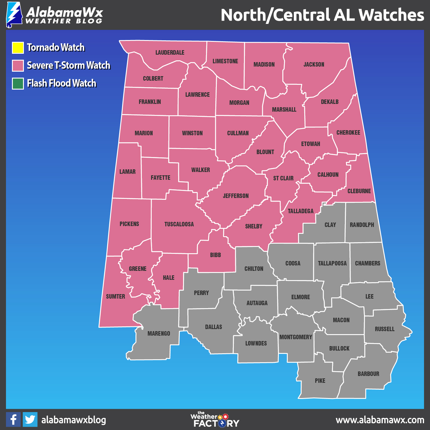
A Severe Thunderstorm Watch is current in effect until 9:00PM tonight for much of the northern half of the state.
LATEST THINKING
We are still on course for having a threat for severe storms this afternoon and into the evening hours. The broad, upper-level through continues to move towards the southeastern states, and supercells and clusters of strong to severe storms are expected to continue to develop ahead of the lagging associated front. CAPE values are still expected to be in the 1000-2000 J/kg range, and along with abundant dry air aloft and 0-6 km shear of 35-45 knots. It appears that the best chance for severe storms will be to the west and northwest of the I-59 corridor, with a lesser threat stretching down as far as the I-85 corridor.
TIMING
The main risk for strong to severe storms across the area today will be from roughly now until 9:00PM this evening. With the cold front lagging and a low-level jet in place, more showers and storms are possible after that during the late evening and overnight hours, but these will not be severe.
WORD OF ADVICE
Continue to be in a position to hear severe weather watches and warnings throughout the day if they are needed. Stay tuned to the Alabama Wx Weather Blog throughout the day for regular updates. Have your NOAA Weather Radio handy and your smart phone charged and nearby.
HEADS UP FOR POSSIBLE SEVERE WEATHER ON THURSDAY
Our next system that will move across the area will be on Thursday afternoon and Thursday night, and the SPC already has much of the state defined in a severe weather risk on their “Day 4” outlook. The synoptic pattern looks favorable for strong to severe storms as of now, but we need to get through today’s event before focusing on Thursday.
Category: ALL POSTS, Severe Weather
About the Author (Author Profile)
Scott Martin is an operational meteorologist, professional graphic artist, musician, husband, and father. Not only is Scott a member of the National Weather Association, but he is also the Central Alabama Chapter of the NWA president. Scott is also the co-founder of Racecast Weather, which provides forecasts for many racing series across the USA. He also supplies forecasts for the BassMaster Elite Series events including the BassMaster Classic.Subscribe
If you enjoyed this article, subscribe to receive more just like it.


