

Calmer Weather Through Tomorrow
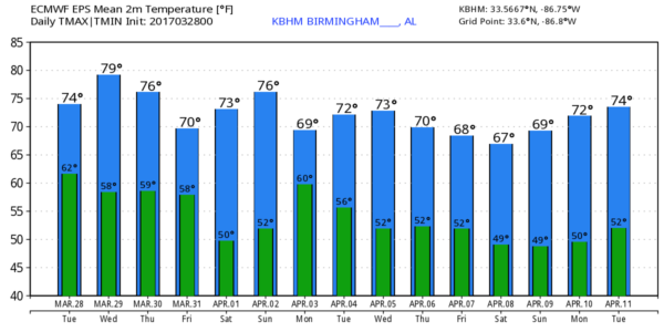
CALMER DAY: A decaying band of showers and storms is moving through Central and East Alabama early this morning after a day of severe storms across the northern third of the state that produced large hail and some damaging wind. Today will feature more clouds than sun, and while showers are possible, they will be widely scattered and a decent part of the day will be dry. The high this afternoon will be in the 70s.
Tomorrow will be warm and dry; with sunshine through scattered clouds afternoon temperatures will rise into the low to mid 80s. And, while we enjoy the nice day, yet another wave in the “wave train” will bring the risk of big storms to areas west of Alabama… places like Shreveport, Little Rock, and Houston will have a risk of severe weather.
MORE STORMS THURSDAY/FRIDAY: SPC has much of Alabama in the standard “slight risk” of severe storms for late Thursday, Thursday night, and early Friday in their “Day Three” outlook that runs from 7a CT Thursday to 7a CT Friday…
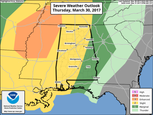
We still have more questions than answers about the threat for our state. Models are hinting that a thunderstorm complex could form along the Gulf Coast, reducing the inflow into the northern half of the state, and in turn reducing the overall severe weather threat. Instability values for now look pretty low, and forecast soundings are not especially favorable for severe storms. But, the overall synoptic pattern certainly supports the idea of strong storms late Thursday, Thursday night, and into Friday morning.
We will get better clarity as we get closer to the event. Rain and storms should slowly diminish during the day Friday with a high in the 70s.
THE ALABAMA WEEKEND: Looks very nice. Mostly sunny Saturday and Sunday with mild afternoons and cool nights; highs in the 70s, early morning lows between 48 and 52.
NEXT WEEK: The wave train remains active; another setup for strong to severe storms shows up around Tuesday April 4… see the Weather Xtreme video for maps, graphics, and more details.
Click here to see the Beach Forecast Center page. Save Up To 25% on Spring Break Beach Vacations on the Alabama Gulf Coast with Brett/Robinson! The Beach Forecast is partially underwritten by the support of Brett/Robinson Vacation Rentals in Gulf Shores and Orange Beach. Click here to see Brett/Robinson’s best beach offers now!.
STORM SPOTTER TRAINING: We will be on the road through early April offering free storm spotter classes. We need more trained spotters in Alabama; by attending you can make the severe weather warning process better. No need to register; just come with a curious mind. And, there is no age limit… kids that love weather will enjoy it. You will never look at a storm the same again. We are at Oxford this evening (at the Oxford Civic Center) and Jasper Thursday (at the Jasper Civic Center). Training begins at 6:30p.
WEATHER BRAINS: Don’t forget you can listen to our weekly 90 minute netcast anytime on the web, or on iTunes. This is the show all about weather featuring many familiar voices, including our meteorologists here at ABC 33/40.
CONNECT: You can find me on all of the major social networks…
Facebook
Twitter
Google Plus
Instagram
Pinterest
Snapchat: spannwx
I have a weather program this morning at Vernon Intermediate School in Lamar County… look for the next Weather Xtreme video here by 4:00 this afternoon. Enjoy the day!
Category: Alabama's Weather, ALL POSTS
About the Author (Author Profile)
James Spann is one of the most recognized and trusted television meteorologists in the industry. He holds the AMS CCM designation and television seals from the AMS and NWA. He is a past winner of the Broadcast Meteorologist of the Year from both professional organizations.Subscribe
If you enjoyed this article, subscribe to receive more just like it.


