

Pretty Nice Out There At Midday & A New Wrinkle Introduced To Thursday’s Severe Threat
SATELLITE/RADAR CHECK
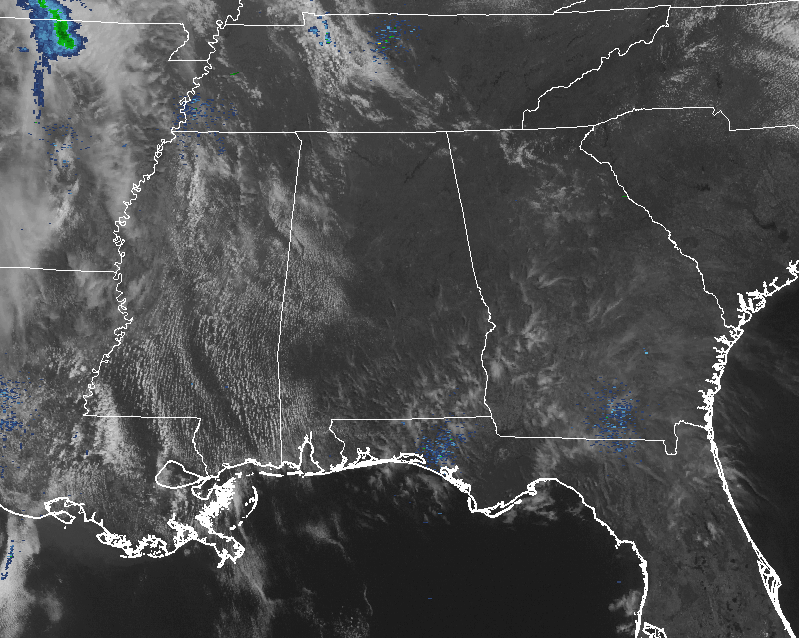
At the midday hour, skies are mainly clear across much of the North/Central Alabama area, with a few clouds over the western parts of the area. Radar is coming up clear as well for not only us, but for nearly all of the southeast. Only a few showers are showing up in the northern parts of Tennessee, while pretty much the remainder of the southeast is enjoying mainly mostly clear skies.
Temperatures across North/Central Alabama are currently up in the lower to upper 70s from north to south, and with plenty of sunshine and a southerly wind, temperatures will quickly make up into the lower to mid 80s from north to south, with a few locations in the extreme southern parts of the area hitting the upper 80s. With warm humid air moving in from the Gulf of Mexico, there will be a very small risk of a few afternoon showers and thunderstorms developing. Most of the North/Central Alabama area will remain dry today, but don’t be surprised that a few locations could get a brief shower.
STRONG TO SEVERE STORMS LIKELY FOR LATE THURSDAY
For the last couple of days, I’m sure that you’ve heard about uncertainties with this system that is expected to bring strong to severe storms across North/Central Alabama for late Thursday afternoon and into the evening hours. Latest trends in the models have backed off on the size and strength of the thunderstorms that will move across the Gulf Coast, another new wrinkle has been added to the mix.
A line of showers and a few storms is projected to move into the state during the late morning hours, which could hamper development of strong to severe storms for the afternoon hours. According to the size of that first wave, and how quickly it moves out, will determine how quickly the atmosphere will recover for later in the day and evening. The main event is expected to get started over the western parts of the state after 6:00PM, and slowly progressing across the area throughout the remainder of the evening into the early morning hours on Friday.
For now, it looks like the best chances for strong to severe storms will be in the northwestern part of the state… mainly along and west of the I-65 corridor, and north of the I-20/59 corridor. A more limited threat will be for the areas just to the east and south of those corridors. This is all dependent on how that first wave affects the atmosphere, or if it even develops. It could disappear in the next model run.
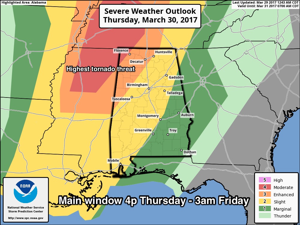
The Storm Prediction Center has the extreme northwestern corner of the state in a moderate risk for severe storms throughout the day on Thursday, including locations just west of Florence and just north of Red Bay, and an enhanced risk for locations west of a line from Huntsville to Carbon Hill to Gordo. A slight risk for severe storms stretches as far to the east as Anniston, Montgomery, and Atmore, with a marginal risk for the remainder of the state.
Threats in the enhanced and moderate risk locations will be from tornadoes, damaging winds in excess of 60 MPH, and large hail up to golf ball size. For the slight risk area, threats will mainly be from damaging winds up to 60 MPH and large hail up to quarter size, with a lesser threat of tornadoes. Marginal risk location risks are the same as the slight risk locations, but are less likely.
The main window for strong to severe storms across North/Central Alabama will be from 4PM Thursday afternoon through 3:00AM Friday. Timing as of now has the storms entering the western parts of the state after 6:00PM, reaching the Birmingham metropolitan area after midnight, and the Gadsden/Anniston areas after 2:00AM on Friday.
Be sure you have a way of getting warnings. A NOAA Weather Radio is the baseline, and a good smart phone app is the other tier. Identify the safe place in your home, and be sure everyone knows where it is. And, in that safe place have helmets for everyone, along with hard sole shoes and preferably a portable airhorn in case you need help.
BEACH FORECAST
Click here to see the Beach Forecast Center page. Save Up To 25% on Spring Break Beach Vacations on the Alabama Gulf Coast with Brett/Robinson! The Beach Forecast is partially underwritten by the support of Brett/Robinson Vacation Rentals in Gulf Shores and Orange Beach. Click here to see Brett/Robinson’s best beach offers now!
STORM SPOTTER TRAINING
The ABC 33/40 Weather Authority team will be on the road through early April offering free storm spotter classes. We need more trained spotters in Alabama. By attending, you can make the severe weather warning process better. No need to register, just come with a curious mind. There is no age limit. Kids that love weather will enjoy it. You will never look at a storm the same again. Thursday’s event in Jasper has been postponed due to the threat of severe weather, and it will be rescheduled. Next week, the team will be at Tuscaloosa on Tuesday (at Shelton State Community College), and at the BJCC (North Meeting Room C-1) on Saturday, April 8th for all-day basic and advanced training, starting at 9:00AM.
WEATHERBRAINS
Don’t forget you can listen to the weekly 90 minute netcast anytime on the web, or on iTunes. This is the show all about weather featuring many familiar voices, including meteorologists at ABC 33/40. Shows are usually produced on Monday evenings starting at 8:30 CDT… you can watch it live here.
Category: Alabama's Weather, ALL POSTS
About the Author (Author Profile)
Scott Martin is an operational meteorologist, professional graphic artist, musician, husband, and father. Not only is Scott a member of the National Weather Association, but he is also the Central Alabama Chapter of the NWA president. Scott is also the co-founder of Racecast Weather, which provides forecasts for many racing series across the USA. He also supplies forecasts for the BassMaster Elite Series events including the BassMaster Classic.Subscribe
If you enjoyed this article, subscribe to receive more just like it.


