

Severe Weather A No-Show; Overnight Storms Then a Nice Weekend
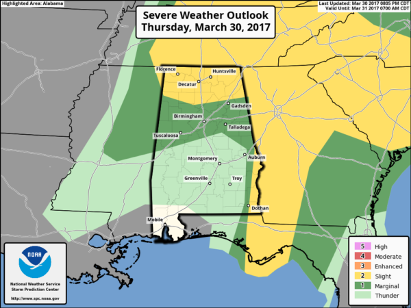
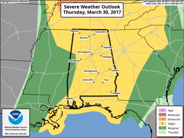
Severe weather outlook from the SPC through 7 a.m., but severe weather is unlikely in Alabama overnight.
UPDATE AT 10:30 PM
For the northern half of Alabama tonight, severe weather has been a no show, thanks to a batch of storms that moved through the southern two-thirds of the state during the morning, cutting off the southerly flow and making the atmosphere relatively stable. There was some minor damage, however, in counties like Cullman due to non-thunderstorm winds related to a wake low/gravity wave on the back side of departing rain.
A thin line of storms will continue pushing through the state through the early morning hours. It may weaken and shrink as it does. In fact, locations north of I-20 may not even see rain overnight.
The weather will be dry and pleasant tomorrow through the weekend… The high Friday afternoon will be in the mid 70s, followed by upper 70s Saturday with a sunny sky both days. Sunday will be a partly sunny day with a high around 80.
NEXT WEEK: Rain and storms are likely Monday; the latest GFS run continues to suggest the surface low will move right through Central Alabama.. meaning a heavy rain threat for the northern half of the state, with severe storms possible near the Gulf Coast. But, remember this could easily change as we get closer to the event. Then, another round of rain and storms is likely by Wednesday. It is a very active spring weather pattern for the southern U.S.
ORIGINAL POST
**No afternoon Weather Xtreme video today due to ongoing weather issues**
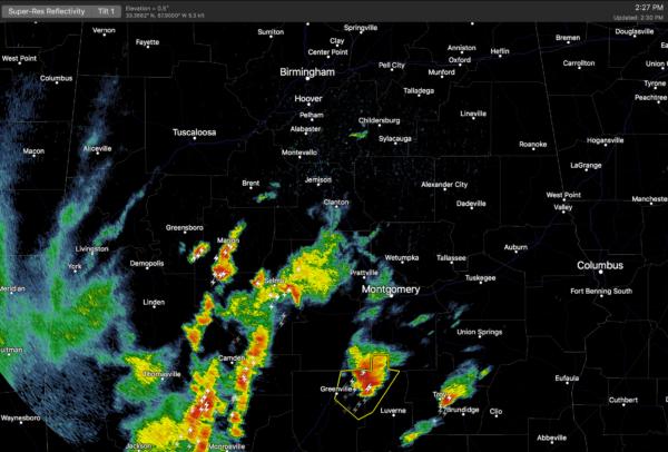
RADAR CHECK: Showers and storms over the southern half of the state are marching northward… some of these storms are producing hail and strong gusty winds…
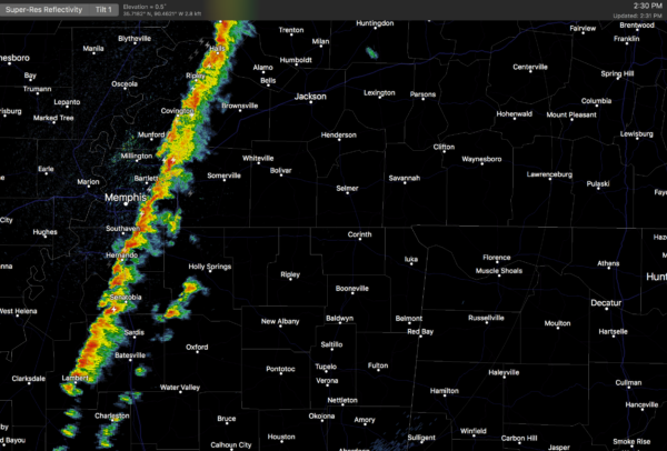
In addition, another line of storms has formed just east of Memphis, and those will move into Northwest Alabama late this afternoon…
SPC maintains a “slight” risk (category two) of severe storms for much of Alabama through the evening…
The storms over South Alabama have clearly disrupted the southerly flow over parts of the state, lessening the overall severe weather threat this evening for the northern half of the state. But, it is important to understand that even with that situation severe storms are still possible statewide through tonight.
The main threats will come from strong straight line winds and hail, but a few isolated tornadoes are still possible.
TIMING: Storms, of course, are in progress over the southern half of the state right now. For North Alabama, the line of storms will enter the state around 4:30-5:00… the progressing slowly eastward. The storms should be over by 2:00 a.m. The main chance of stronger storms for places like Tuscaloosa, Birmingham, Anniston, and Gadsden will come from about 7:00 until 10:00 p.m.
The blog will be updated frequently through the event, so check in often.
TOMORROW THROUGH THE WEEKEND: The weather will be dry and pleasant. The high tomorrow will be in the mid 70s, followed by upper 70s Saturday with a sunny sky both days. Sunday will be a partly sunny day with a high around 80.
NEXT WEEK: Rain and storms are likely Monday; the latest GFS run continues to suggest the surface low will move right through Central Alabama.. meaning a heavy rain threat for the northern half of the state, with severe storms possible near the Gulf Coast. But, remember this could easily change as we get closer to the event. Then, another round of rain and storms is likely by Wednesday.
Click here to see the Beach Forecast Center page. Save Up To 25% on Spring Break Beach Vacations on the Alabama Gulf Coast with Brett/Robinson! The Beach Forecast is partially underwritten by the support of Brett/Robinson Vacation Rentals in Gulf Shores and Orange Beach. Click here to see Brett/Robinson’s best beach offers now!.
STORM SPOTTER TRAINING: We will be on the road through April offering free storm spotter classes. We need more trained spotters in Alabama; by attending you can make the severe weather warning process better. No need to register; just come with a curious mind. And, there is no age limit… kids that love weather will enjoy it. You will never look at a storm the same again. The next training is in Tuscaloosa Tuesday evening (April 4) at 6:30 at Shelton State Community College.
WEATHER BRAINS: Don’t forget you can listen to our weekly 90 minute netcast anytime on the web, or on iTunes. This is the show all about weather featuring many familiar voices, including our meteorologists here at ABC 33/40.
CONNECT: You can find me on all of the major social networks…
Facebook
Twitter
Google Plus
Instagram
Pinterest
Snapchat: spannwx
I will have the next Weather Xtreme video here by 7:00 a.m. tomorrow… and stay tuned for frequent blog updates tonight…
Category: Alabama's Weather, ALL POSTS
About the Author (Author Profile)
James Spann is one of the most recognized and trusted television meteorologists in the industry. He holds the AMS CCM designation and television seals from the AMS and NWA. He is a past winner of the Broadcast Meteorologist of the Year from both professional organizations.Subscribe
If you enjoyed this article, subscribe to receive more just like it.


