

Strong Storms Affecting Multiple Locations in Extreme North Alabama
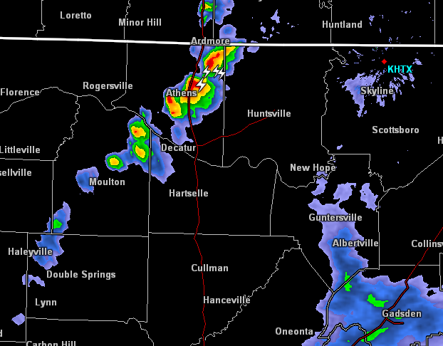
At 542 PM CDT, Doppler radar was tracking a strong thunderstorm near Moulton, moving northeast at 40 mph. Pea size hail and winds in excess of 30 mph will be possible with this storm. Locations impacted include Decatur, Athens, Moulton, Trinity, Tanner, Hillsboro, Mooresville, Cartwright, Coxey and French Mill.
At 546 PM CDT, Doppler radar was tracking an areas of showers with strong winds near Strawberry, or near Arab, moving northeast at 30 mph. A wake low or gravity wave has formed on the backside of the decaying showers. Winds of 40 to 50 mph are possible with this area of showers. Locations impacted include Albertville, Scottsboro, Boaz, Guntersville, Arab, Crossville, Owens Cross Roads, Geraldine, Grant and Gurley.
At 558 PM CDT, Doppler radar was tracking a strong thunderstorm near Ardmore, or 12 miles northeast of Athens, moving northeast at 35 mph. Pea size hail and winds in excess of 30 mph will be possible with this storm. Locations impacted include Fayetteville, Ardmore, Harvest, Elkmont, Elkwood, Holland Gin, Blanche, Coldwater, Capshaw and Dellrose.
Category: ALL POSTS, Severe Weather
About the Author (Author Profile)
Scott Martin is an operational meteorologist, professional graphic artist, musician, husband, and father. Not only is Scott a member of the National Weather Association, but he is also the Central Alabama Chapter of the NWA president. Scott is also the co-founder of Racecast Weather, which provides forecasts for many racing series across the USA. He also supplies forecasts for the BassMaster Elite Series events including the BassMaster Classic.Subscribe
If you enjoyed this article, subscribe to receive more just like it.


