

A Quick Look At Alabama’s Weather Situation At 6:25PM
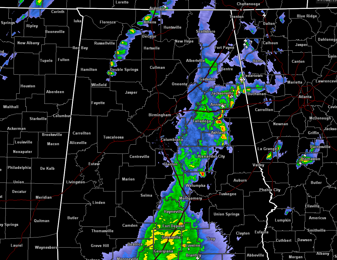
A line of showers and storms that is responsible for giving all of us meteorologist a good fit today, is currently making its way through the eastern half of Alabama at this moment. Even though there have been a fell strong storms embedded in this line, the main story is the wake low that has been occurring along the backside.
We do have a secondary area of storms that has developed right behind this first line that is currently affecting parts of Lawrence, Madison, Lauderdale, Morgan, Franklin, and Limestone counties, and the NWS Huntsville office has issued a Significant Weather Advisory for these storms until 6:45PM. At 617 PM CDT, Doppler radar was tracking a line of thunderstorms 8 miles west of Moulton, extending southwest to northeast moving north-northeast at 35 mph. Pea size hail and wind gusts up to 50 mph will be possible with this storm. Locations impacted include Decatur, Athens, Moulton, Trinity, Rogersville, Ardmore, Phil Campbell, Town Creek, Courtland and Harvest.
Back to our west, another line of storms are moving through the northern parts of Mississippi at this moment. this line is really thin and there is not a lot of lightning involved. This line will move into the northern parts of Alabama within the next 2 hours. The possibility is still there for a strong to severe storm, but that risk is very low as of now.
Speaking of low risks, the latest Hazardous Weather Outlook for the rest of this evening from the NWS Birmingham office is stating that no hazardous weather is expected at this time. So I believe that the severe weather threat south of the US-278 is pretty much done for for the remainder of the evening. The latest run of the HRRR model, which handled this event almost completely perfect, agrees with that thinking. A few more showers or storms could develop along the cold front as it moves in and across the state, but most location will get little to no additional precipitation tonight with the front.
Category: ALL POSTS, Severe Weather
About the Author (Author Profile)
Scott Martin is an operational meteorologist, professional graphic artist, musician, husband, and father. Not only is Scott a member of the National Weather Association, but he is also the Central Alabama Chapter of the NWA president. Scott is also the co-founder of Racecast Weather, which provides forecasts for many racing series across the USA. He also supplies forecasts for the BassMaster Elite Series events including the BassMaster Classic.Subscribe
If you enjoyed this article, subscribe to receive more just like it.


