

Update on Alabama’s Weather at 8 p.m.
All is still quiet across North and central Alabama at this hour as we continue to watch severe weather to the west of Alabama. Clouds are thickening and lowering from the west as storms approach from Mississippi. Temperaures are in the middl and upper 70s still, quite comfortable. The airmass that has been quite dry all day is starting moisten as evidenced by the dew point at Tuscaloosa that has gone from 44 to 53F over the past few hours.
Aloft, a deep trough has cut off into an upper level low over West Texas. A strong low level jet is over western Mississippi.
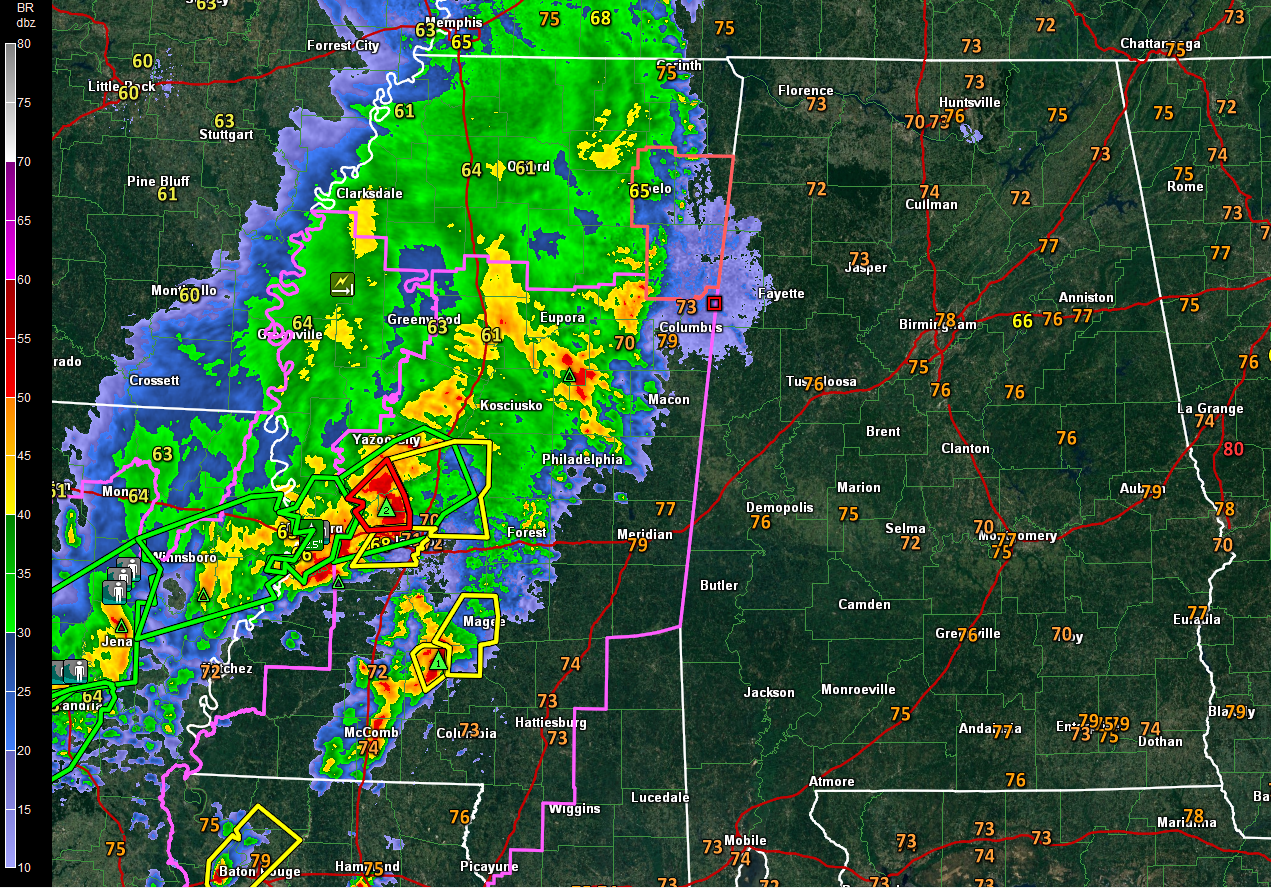
A weak surface low is near Memphis. An arc of thunderstorms extends from the low near Memphis to near Tupelo to Yazoo City to just west of Jackson to Alexandria, LA on to Beaumont, Texas.
Tornado watches cover much of Mississippi and Louisiana and extend into extreme eastern Texas. A small severe thunderstorm watch includes 2 counties in northern Mississippi.
A tornado warning is in effect for several counties just northwest of Jackson for a very mean looking storm that will clip Metro Jackson. Severe thunderstorm warning just issued for Jackson.
Numerous flash flood warnings cover a large area from Central Mississippi across Central Louisiana into Southeast Texas. Numerous reports of flash flooding are occurring across Central Louisiana. Numerous rads are impassable across Vernon Parish LA. 40% of the roads in Pollock LA northeast of Alexandria are flooded. Numerous roads across Grant Parish are flooded as well.
Showers and storms are now within about 30 miles of Lamar and Marion Counties of West Alabama. But the airmass over Alabama continues to be quite dry and storms will generally fall apart as they enter the state for the next few hours. Rain will gradually increase over the border counties from Lauderdale and Colbert through Marion, Lamar, Fayette and Pickens through midnight and spreading east and northeast slowly through 2 a.m.
The main line of storms will enter West Alabama’s after 2 a.m. Some of these storms could be severe with damaging winds and hail. The storms should reach Jasper and Tuscaloosa by 3-5 a.m., Birmingham between 4-6 a.m. and Anniston by 7-9 a.m. They should reach Auburn before noon.
The SPC has nosed the slight and enhanced risks a little further into Alabama for the overnight hours. Here is the SPC severe weather outlook for the overnight hours through 7 a.m. Monday:
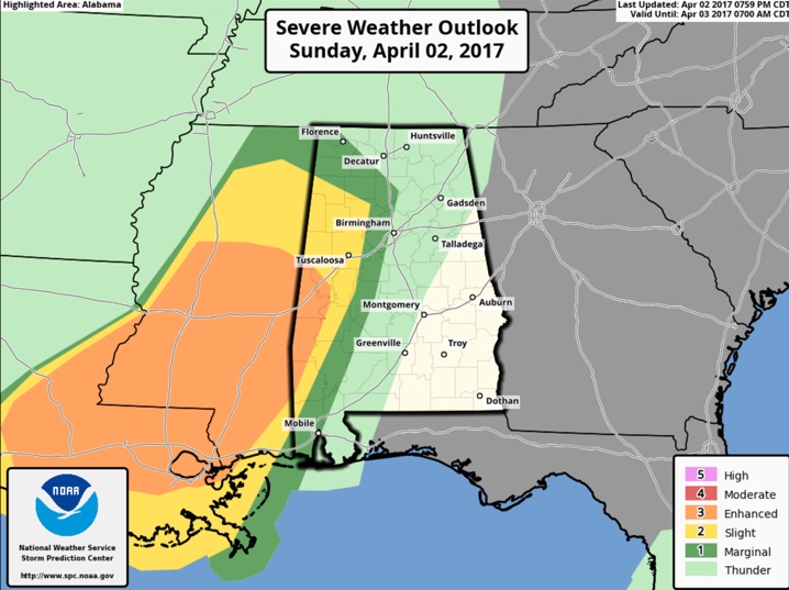
Most of North Central Alabama is in a slight risk severe weather outlook tomorrow from the SPC. Areas south of a line from Tuscaloosa to Birmingham to Gadsden roughly have an enhanced risk, with a damaging winds possible and an isolated tornado or two as well. Areas south of a line from roughly Linden to Clanton to Lafayette are in a moderate risk, meaning widespread severe storms are likely.
Rain should end for areas west of I-59 by noon.
There will be some showers over northern Mississippi that will enter North Alabama late in the day, but they should not be severe.
We will have frequent updates throughout the night and tomorrow as this system moves through. Another round of severe weather is expected on Wednesday.
Category: ALL POSTS, Severe Weather
About the Author (Author Profile)
Bill Murray is the President of The Weather Factory. He is the site's official weather historian and a weekend forecaster. He also anchors the site's severe weather coverage. Bill Murray is the proud holder of National Weather Association Digital Seal #0001 @wxhistorianSubscribe
If you enjoyed this article, subscribe to receive more just like it.


