

Another Severe Weather Threat Wednesday
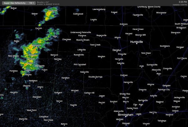
ONE MORE BATCH OF SHOWERS THIS EVENING: Radar shows a band of showers and storms over Northeast Mississippi; these will move across the northern third of Alabama this evening, but the air was totally worked over by the morning storms, and the risk of additional severe weather is low. Just a “marginal risk” of severe storms this evening over Northwest Alabama, where gusty winds and some small hail is possible.
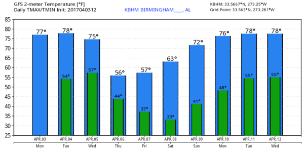
Tomorrow will be warm and dry, with a good supply of sunshine and a high in the low 80s.
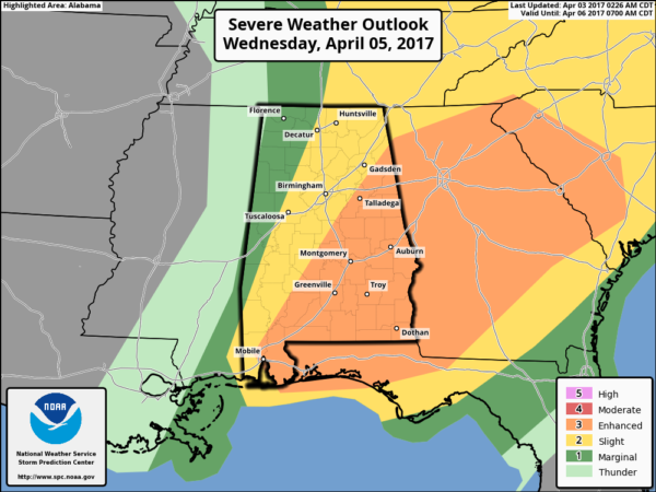
MORE SEVERE WEATHER ISSUES: We have an “enhanced risk” of severe storms Wednesday in Alabama east of a line from Centre to Clanton to Selma to Jackson to Mobile… a “slight risk” includes Tuscaloosa, Birmingham, and Gadsden…
A very dynamic system with strong wind fields will impact the state with a fairly complex scenario.
WEDNESDAY MORNING: One batch of storms will blow through early Wednesday morning with a warm front lifting northward. These are most likely from 4 until 9 a.m… and some of these could be severe, with the main threat coming from hail and strong straight line winds, although an isolated tornado can’t be totally ruled out.
WEDNESDAY AFTERNOON: After a midday break in the rain, more storms will develop Wednesday afternoon into the evening hours. Instability values are forecast to soar, with surface based CAPE values nearing 3,000-4,000 j/kg by 4-5 p.m. With a strong low level jet and favorable shear profiles, some of these storms could be supercells with potential for large hail, damaging wind, and a few tornadoes. A strong tornado or two is certainly possible in the “enhanced risk” area.. and I would not be surprised if SPC upgrades this to a “moderate risk” (level 4 out of 5) in future outlooks based on forecast parameters.
But, understand the impact of the morning storms isn’t known, and there remains uncertainty in how the afternoon convection evolves. The bottom line is that Wednesday looks like an active severe weather day for much of Alabama, especially the eastern half of the state. Just pay attention to the blog discussions tomorrow and have a way of getting watches and warnings.
LATE SEASON COLD SNAP: After the stormy day Wednesday, much cooler air blows in Thursday. We will forecast gradual clearing; otherwise the day will be breezy and cool with temperatures in the 50s much of the day. Friday will be sunny, but the morning will be cold as we begin the day in the the upper 30s. The high Friday will be in the low 60s.
The coldest morning will come early Saturday; most places will see a low between 34 and 39 with potential for frost. Colder pockets have a good chance of going below freezing. This is the April cold snap we almost always have annually. And, why we advise not planting anything that might be harmed by a freeze until April 15.
THE WEEKEND: Expect a bright sunny sky Saturday and Sunday with a warming trend… the high Saturday will be in the upper 60s, followed by upper 70s Sunday.
NEXT WEEK: The wave train seems to shut down temporarily, and for the moment the week looks fairly quiet with an upper ridge building across the eastern U.S. See the Weather Xtreme video for maps, graphics, and more details.
Click here to see the Beach Forecast Center page. Save Up To 25% on Spring Break Beach Vacations on the Alabama Gulf Coast with Brett/Robinson! The Beach Forecast is partially underwritten by the support of Brett/Robinson Vacation Rentals in Gulf Shores and Orange Beach. Click here to see Brett/Robinson’s best beach offers now!.
STORM SPOTTER TRAINING: We will be on the road through April offering free storm spotter classes. We need more trained spotters in Alabama; by attending you can make the severe weather warning process better. No need to register; just come with a curious mind. And, there is no age limit… kids that love weather will enjoy it. You will never look at a storm the same again. The next training is in Tuscaloosa tomorrow evening (April 4) at 6:30 at Shelton State Community College. No need to register, just come with a curious mind.
WEATHER BRAINS: Don’t forget you can listen to our weekly 90 minute netcast anytime on the web, or on iTunes. This is the show all about weather featuring many familiar voices, including our meteorologists here at ABC 33/40. We will produce this week’s show tonight at 8:30… you can watch it live here.
CONNECT: You can find me on all of the major social networks…
Facebook
Twitter
Google Plus
Instagram
Pinterest
Snapchat: spannwx
Look for the next Weather Xtreme video here by 7:00 a.m. tomorrow…
Category: Alabama's Weather, ALL POSTS
About the Author (Author Profile)
James Spann is one of the most recognized and trusted television meteorologists in the industry. He holds the AMS CCM designation and television seals from the AMS and NWA. He is a past winner of the Broadcast Meteorologist of the Year from both professional organizations.Subscribe
If you enjoyed this article, subscribe to receive more just like it.


