


By Bill Murray and Scott Martin
We continue to pore over model data this morning for tomorrow’s severe weather event and there are plenty of things that concern us. Scott and I have collaborated on a long post to show all our work for tomorrow’s event. We hope you will follow along and see some of our thinking. We certainly don’t want to alarm anybody, but enough signs are there that we will have some strong, potentially long track tornadoes across Alabama and Georgia, perhaps into South Carolina.
One big difference is that the weather will be developing right over us and moving off to the east, unlike many of our events, especially recently. It remains to be seen exactly where the storms will fire, but it does appear that it could be west of I-65 around lunch time, placing the greatest threat east of I-65 during the afternoon and early evening. We will be able to tell more overnight.
Morning runs of the 4k NAM and the WRF support the idea of morning storms with some hail along a northward moving warm front across Central Alabama. The morning storms will be mainly elevated with lots of lightning and loud thunder. But remember, lightning and thunder do not make a thunderstorm severe; it is the winds (58 mph or greater) or the hail (one inch or larger). Damaging wind and hail will be possible, and we can’t rule out a tornado either during the early morning hours.
With such a situation where we see morning storms, there is always a question about whether the atmosphere will have time to recharge. The front that came through Alabama yesterday stalled over northern Florida, so it didn’t have a chance to clear all those high dewpoint out from over the northern Gulf of Mexico. It you looked on Sunday, there were 76-77F dewpoints over southern Louisiana. That high moisture air will be transported up into South and Central Alabama early tomorrow morning.
To see examples where the atmosphere recharged, go back to April 27, 2011, or to April 4, 1977. The 2011 Super outbreak and the 1977 Smithfield F5 Tornado are examples where that happened.
There will be no competition from convection along the Gulf Coast during the day, so there will be no questions about moisture being robbed by southern storms.
The models seems to be showing a good deal of consensus, so that increases our confidence. The morning run (12z, or 7 am) of the GFS is already out far enough to see the entire event. Let’s sort of walk through the parameters here and talk about how the situation could unfold.
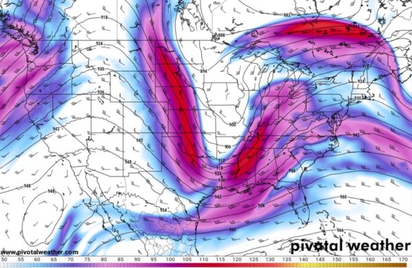
Tomorrow morning at 7 a.m., we will have an upper level trough from Missouri through eastern Kansas, Central Oklahoma and back into West Texas. Strong jet stream level winds of 125 knots will be blowing around the southeastern side of that trough.
An intensifying surface low will be over over southern Missouri (999 mb – GFS). By mid-afternoon, it will be over southern Illinois (995 mb). Our pressures will be low enough (29.70 or lower) to support strong storms. Our pressure fall tomorrow will be modest, but sufficient to support severe weather.
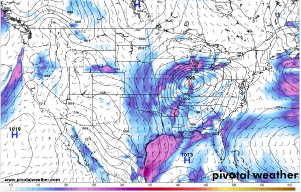
This cyclone will pull the warm front northeast during the morning, accompanied by those showers and storms. All of this “junky” convection will be over North Georgia by early afternoon and it looks like Alabama will be solidly in the warm sector of the low, with temperatures in the lower and middle 70s and dewpoints of 66-69F.
Those of you who have been reading this long enough know that 65F dewpoints are sort of a threshold for big events
We will have a decent 850 mb jet (about 5000 feet) of around 35 knots or so. Our 850 mb dewpoints will be around 12-13C, which is favorable for severe weather. Deep moisture will certainly not be the question. And severe storms like dry air around 700 mb (10,000 feet). That will certainly be present as well. In fact, many times you can have too much moisture in the atmosphere. That will not be the case tomorrow with precipitable water values of just over an inch.
At 500 millibars (18,000 feet or so) winds will be plenty sufficient for severe storms, with 60-70 knots, which is well above the 50 knot threshold for significant severe weather. We will be experiencing positive vorticity advection as well, and the heights will fall over 60 meters during the day tomorrow, another sign of severe weather.
A cyclonic upper level jet will be pushing toward us, putting us in a favorable region of upper level divergence and upward vertical motion. Our winds at the 300 mb level (30,000 feet) will be over 80 knots, which is very favorable for severe storms.
Shear won’t be a problem either, with bulk shear between the surface and 500 mb (18,000 feet) over 50 knots. This is very favorable for big storms, especially given the high instability.
LET’S TALK PARAMETERS
And what about the instability? That certainly won’t be a problem, with over 2500 j/kg across much of the area. Lapse rates (temperature decreasing with height) won’t be either, with values over 7C. Anything over 6C is favorable for severe weather. Lifted index values will be high, pushing -9C by midafternoon.
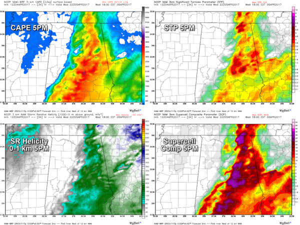
Parameters from the 3km NAM
Low level helicity values look favorable for tornadoes as well, running 150-200 m2/s2.
The Significant Tornado Parameter is one we pay lots of attention to. At 5 p.m. it is over 1 (the threshold) over much of the area east of I-65 with large areas of 2-4. The Supercell Composite is also high, so supercell thunderstorms will be the order of the day. Those are the kings of thunderstorms, the kinds that can produce lots of severe weather, including significant tornadoes.
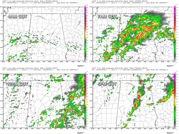
Simulated radar looks from the NAM3K at 4am, 7am, noon and 5 pm.
FORMATION AND EVOLUTION OF THE STORMS
Looking at the latest model trend from the NAM-3k, the warm front will be moving north through the central parts of Alabama and will be located over or near Pickens and Tuscaloosa counties, and draping to the east-southeast over to Coosa, Tallapoosa, and Lee counties at approximately 3-5AM.
Showers and storms will be in the process of developing and will increase rapidly during the early morning. These storms will multiply across Central Alabama, and some have the possibility of becoming strong to severe. Mainly anything north of the I-20 corridor will be elevated in nature, but hail and damaging winds could be possible with these, while the storms to the south could have a few tornadoes involved.
Most of these storms will have pushed into Georgia by the 11AM-1PM time frame, and there could be a lull in the action across most of the area. Our atmosphere will continue to destabilize and we might even have some sun pop out to help with that.
What is even more concerning is that this system will have a dryline like we see with systems over the Plains states. That dryline will have developed over the middle of Mississippi and will be moving towards Alabama, triggering storms. As this dryline moves east, storms will begin to develop and these will be in either supercell in structure or in clusters of strong to severe storms.
We will have plenty of instability and wind shear (turning of the winds with height) at around 3-4PM across the area, and we have the potential for several rotating storms that could produce large long-track tornadoes, especially for locations along and east of I-65. This will continue through the evening hours and exit the state by 8-9PM.
Sorry to spend so much time on the geeky part of the weather, but this could be a really active weather day.
WILL IT BE LIKE APRIL 27TH?
Will it be like April 27th? April 27, 2011 was a generational event. Just understand if there is only one tornado in the entire state, and if comes down your street, then it’s your April 27th.
BE READY
Be sure to have your smartphone charged and fresh batteries in your flash lights, radios, and your NOAA Weather Radio. Know where your safe place is in your home, and be sure everyone know where it is. Already have helmets and hard sole shoes in there for everyone, and have a portable airhorn in case you need help.


