

Warming Trend for the Weekend
* * * No Weather Xtreme Video this morning due to the spotter training event at the BJCC. Look for a video Sunday morning. * * *
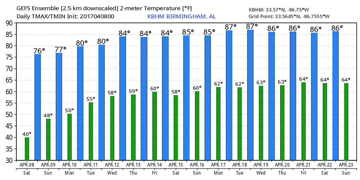
A large surface high pressure system was centered over Central Alabama this morning with mostly clear skies with just a few clouds over the Tennessee River Valley. Good radiational cooling had allowed temperatures across much of North and Central Alabama to drop into the 30s. Our Skywatcher at Black Creek reported a low of 30 degrees with frost. The trough along the East Coast will gradually move into the Atlantic allowing the cool northwesterly flow to weaken as upper ridging moves our way. This should be enough to allow our highs to climb into the lower 70s today and into the upper 70s on Sunday as the upper ridge becomes the primary player in the upper flow for us.
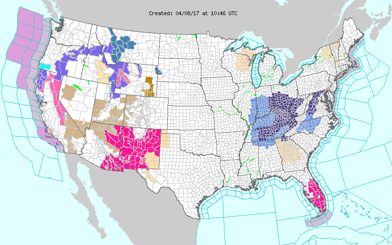
The watch/warning map this morning was a bit busy with frost/freeze warnings over a large section of the southern Appalachians. High fire danger warnings were in place across Arizona and New Mexico as well as southern Florida. Several winter weather advisories were in place over the northern half of the Rockies.
The upper ridge will move eastward Monday and Tuesday as traveling troughs move across the northern tier of the US helping to beat down the upper ridge. A cold front will move into the Southeast US on Tuesday, but as the front gradually becomes parallel to the upper flow on Tuesday and Wednesday, it is forecast to wash out. The European has a very similar solution to the GFS with only small timing differences with the GFS a few hours faster. There may be enough moisture for an isolated shower or two, but I think most of us remain dry.
The upper ridge gradually redevelops over the eastern half of the country from Thursday through Friday and into the start of the weekend. Other than some passing clouds from time to time, it appears likely that we remain dry for the end of the week and into next weekend. Temperatures are not forecast to vary very much for the week ahead. Highs by Wednesday and into the latter portion of the week should reach the lower 80s.
With somewhat tranquil weather for Central Alabama for the week ahead, the 5-day QPF shows very little rain for Alabama with the best rain chances over the northwest corner of Alabama.
Looking out into voodoo country, the GFS is rather bullish on keeping the upper ridge in place over the eastern half of the country through much of week 2. In fact, the upper ridge is forecast to remain strong enough to keep any traveling short waves well north of Alabama until 372 hours. The GFS then brings a strong upper trough across the southern Rockies promising some stormy weather for the Lower Mississippi River Valley and Central Plains around the 24th of April. But you know how voodoo country can be, so we’ll watch it to see if the ridge remains strong as the GFS suggests today.
Beach weather looks great, too. Sunshine will be plentiful along the Alabama and Northwest Florida Gulf Coast with highs mainly in the 70s. Lows will be cool tonight as they drop into the 50s but after that the lows will be only in the 60s. Click here to see the Beach Forecast Center page. Save Up To 25% on Spring Break Beach Vacations on the Alabama Gulf Coast with Brett/Robinson! The Beach Forecast is partially underwritten by the support of Brett/Robinson Vacation Rentals in Gulf Shores and Orange Beach. Click here to see Brett/Robinson’s best beach offers now!.
WEATHER BRAINS: Don’t forget you can listen to our weekly 90 minute netcast anytime on the web, or on iTunes. This is the show all about weather featuring many familiar voices, including our meteorologists here at ABC 33/40.
Always excited to be participating in the Storm Spotter Xtreme at the BJCC today from about 9 am to 3 pm or so. We’ll be doing a basic storm spotter session in the morning with an advanced spotter session in the afternoon generally between 12:30 and 2:30 pm. If you have an interest in the weather, hope to see you there. I anticipate having a full Weather Xtreme Video posted here Sunday morning. I appreciate your indulgence in my skipping the video this morning in order to get to the BJCC in a timely manner. Have a great day no matter what your plans are. Godspeed.
-Brian-
Category: Alabama's Weather, ALL POSTS
About the Author (Author Profile)
Brian Peters is one of the television meteorologists at ABC3340 in Birmingham and a retired NWS Warning Coordination Meteorologist. He handles the weekend Weather Xtreme Videos and forecast discussion and is the Webmaster for the popular WeatherBrains podcast.Subscribe
If you enjoyed this article, subscribe to receive more just like it.


