

Warm, Dry Pattern Through The Weekend
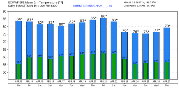
UPPER RIDGE BUILDS: The primary storm track that pushes mid latitude waves across North America is now well to the north of here, and with an upper ridge building that will mean warm, mostly dry weather for Alabama through the Easter weekend. Partly to mostly sunny days, fair pleasant nights. Afternoon highs will be in the 81-85 degree range, morning lows in the upper 50s and low 60s. Average highs around here in mid April are in the mid 70s; we will stay well above those levels through much of next week.
We might consider the risk of a few isolated showers late in the Easter weekend with a slight increase in moisture, but for now we won’t mention it with the ridge holding strong.
NEXT WEEK: A surface front will drop southward through Tennessee, and that will bring the chance of a few scattered showers to the northern third of the state Monday and possibly Tuesday, but again rain amounts will be light, and the front dissipates by mid-week. The GFS hints a more significant cold will arrive around Saturday April 22 with a better chance of rain, but that is in the land of voodoo and could easily change. See the Weather Xtreme video for maps, graphics, and more details.
Click here to see the Beach Forecast Center page. Save Up To 25% on Spring Break Beach Vacations on the Alabama Gulf Coast with Brett/Robinson! The Beach Forecast is partially underwritten by the support of Brett/Robinson Vacation Rentals in Gulf Shores and Orange Beach. Click here to see Brett/Robinson’s best beach offers now!.
ON THIS DATE IN 1979: A storm system approaching Alabama in the middle of April 1979 brought extreme rainfall; four to eight inches of rain were common in north Alabama, with totals as high as 10-15 inches in the western counties. Record or near record crests occurred along much of the Tombigbee, Black Warrior and Sucarnoochee Rivers with severe residential and commercial flooding in areas such as Tuscaloosa, Demopolis, Gainesville and Livingston. Thousands of acres of farm lands, woodlands, and pasture lands were flooded, as well as numerous camps and cabins along these rivers. The Tombigbee River at Demopolis crested April 18, at 37.03 feet, more than 24 feet above flood stage and 1.3 feet above the previous record, established in 1961.
Widespread significant, but less severe, flooding occurred on many other rivers, including the Alabama, Coosa, Tallapoosa and Cahaba Rivers, with some residential flooding occurring in the vicinities of Montgomery, Gadsden and the Tallapoosa Water Plant. When all the floodwaters had receded, damage was estimated at $75 million with at least 15 deaths in the state.
WEATHER BRAINS: Don’t forget you can listen to our weekly 90 minute netcast anytime on the web, or on iTunes. This is the show all about weather featuring many familiar voices, including our meteorologists here at ABC 33/40.
CONNECT: You can find me on all of the major social networks…
Facebook
Twitter
Google Plus
Instagram
Pinterest
Snapchat: spannwx
Look for the next Weather Xtreme video here by 4:00 this afternoon… enjoy the day!
Category: Alabama's Weather, ALL POSTS
About the Author (Author Profile)
James Spann is one of the most recognized and trusted television meteorologists in the industry. He holds the AMS CCM designation and television seals from the AMS and NWA. He is a past winner of the Broadcast Meteorologist of the Year from both professional organizations.Subscribe
If you enjoyed this article, subscribe to receive more just like it.


