

The Latest Weather Xtreme Video: Warm Through Friday; Stormy Weekend
RADAR CHECK: We have a few isolated showers and storms on radar this afternoon over far North and East Alabama… these will dissipate soon after sunset…
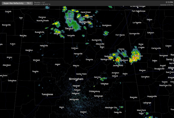
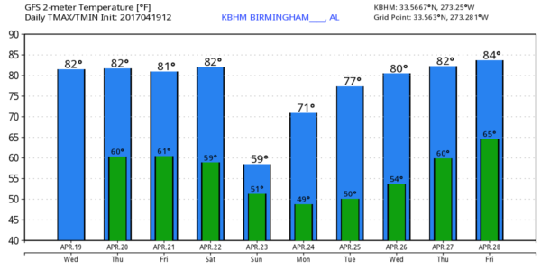
Away from the showers, it is a warm day with a mix of sun and clouds; temperatures are in the mid 80s, about ten degrees above average for mid to late April in Alabama. No records, however… we need to reach the low 90s to tie records for April 19.
Unless an isolated shower forms over the city this evening, today will be the 15th consecutive day without measurable rain at Birmingham.
Tomorrow will be much like today; very warm with only isolated afternoon showers or storms. The chance of any one spot getting wet tomorrow afternoon is only about one in ten. Then, we do expect an increase in the number of scattered showers and storms Friday afternoon and evening with the approach of a surface front from the north. The weather stays warm with a high between 81 and 84 degrees Friday afternoon.
THE WEEKEND: A weather system will bring rain and storms to Alabama, but it won’t rain all weekend. Here is our latest thinking based on new model data this morning…
*The main window for the heavier storms will come from 5:00 p.m. Saturday until 3:00 a.m. Sunday. Light rain could linger through the morning hours Sunday. But the news is generally good for the daytime events around the state Saturday with the later arrival time.
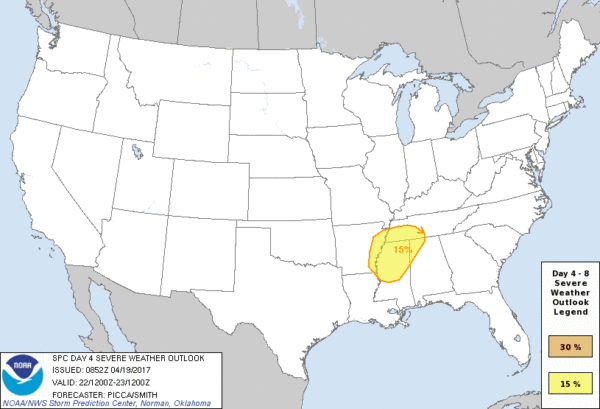
*While forecast shear and instability will support strong, possibly severe storms, it doesn’t look like a “red letter day” by any means. Heavier storms Saturday night could produce hail and strong gusty winds; the overall tornado threat, for now, looks fairly low. SPC has defined a severe weather risk for the northwest corner of the state in their “Day 4” outlook which includes Saturday night.
*Rain amounts should be in the 1/2 to 1 inch range; no flooding issues are expected.
Remember, we are still a few days away, and this forecast could change, so keep in touch with the latest blog discussions.
Sunday will be much cooler with highs only in the low to mid 60s… some communities across North Alabama could even hold in the 50s all day with a cool north breeze.
NEXT WEEK: Monday morning will be cool with upper 40s likely; then the rest of the week will be dry with a warming trend… we reach the 80s again by Thursday and Friday. See the Weather Xtreme video for maps, graphics, and more details.
PRE-SEASON TROPICAL ACTION: “Sub-tropical depression one” formed this morning in the eastern Atlantic, west of the Azores… it has top winds of 35 mph, and probably won’t last beyond the next 36 hours.
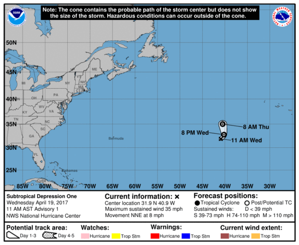
The subtropical depression is forecast to become absorbed by a large extratropical low tomorrow, and is no threat to land. The hurricane season “officially” begins June 1.
HONDA INDY GRAND PRIX IS THIS WEEKEND: It begins Friday at the beautiful Barber Motorsports Park! Make plans for the event that has been voted “Best Annual Event” & “Best Sporting Event” in Birmingham. Kids 15 & under are admitted free with a ticketed adult, and three-day general admission tickets are $69. Single day tickets are $15. Pack a picnic/cooler and bring the family out for a weekend full of activities and racing! Get tickets and more information here. The weather news is pretty good…. looks like the main risk of rain and storms will be Saturday night, without much impact on races during the daytime hours Saturday and Sunday. Get the detailed race cast here.
ALABAMA A DAY: The annual spring game kicks off at 2:00 Saturday afternoon at Bryant-Denny Stadium in Tuscaloosa. The latest model data suggests there is a reasonable chance that most of the rain and storms will arrive after 5:00 p.m… meaning a pretty good chance most of the game will be played with dry conditions. The temperature will be near 80 degrees at kickoff.. I will be doing “Drive Home Weather” on the big screens with former Tide star Andre Smith (now with the Cincinnati Bengals). Come see us in the fan zone at the KS Services booth from 11am until 12 noon.
Click here to see the Beach Forecast Center page. Save Up To 25% on Spring Break Beach Vacations on the Alabama Gulf Coast with Brett/Robinson! The Beach Forecast is partially underwritten by the support of Brett/Robinson Vacation Rentals in Gulf Shores and Orange Beach. Click here to see Brett/Robinson’s best beach offers now!
STORM SPOTTER TRAINING IN JASPER TOMORROW EVENING: The last spotter training event of the year will be held in Jasper tomorrow; we will be at the Jasper Civic Center, and the session begins at 6:30. It is free, and there is no need to register. Just come with a curious mind!
WEATHER BRAINS: Don’t forget you can listen to our weekly 90 minute netcast anytime on the web, or on iTunes. This is the show all about weather featuring many familiar voices, including our meteorologists here at ABC 33/40.
CONNECT: You can find me on all of the major social networks…
Facebook
Twitter
Google Plus
Instagram
Pinterest
Snapchat: spannwx
I enjoyed seeing the kindergarten students at Paine Elementary in Trussville… and Leeds Primary School today… be looking for them on the Pepsi KIDCAM today at 5:00 and 6:00 on ABC 33/40 News! The next Weather Xtreme video will be posted here by 7:00 a.m. tomorrow…
Category: Alabama's Weather, ALL POSTS, Weather Xtreme Videos
About the Author (Author Profile)
James Spann is one of the most recognized and trusted television meteorologists in the industry. He holds the AMS CCM designation and television seals from the AMS and NWA. He is a past winner of the Broadcast Meteorologist of the Year from both professional organizations.Subscribe
If you enjoyed this article, subscribe to receive more just like it.


