

Radar Update at 8:15 a.m.: Most Folks Stay Dry, But Keep Rain Gear Handy
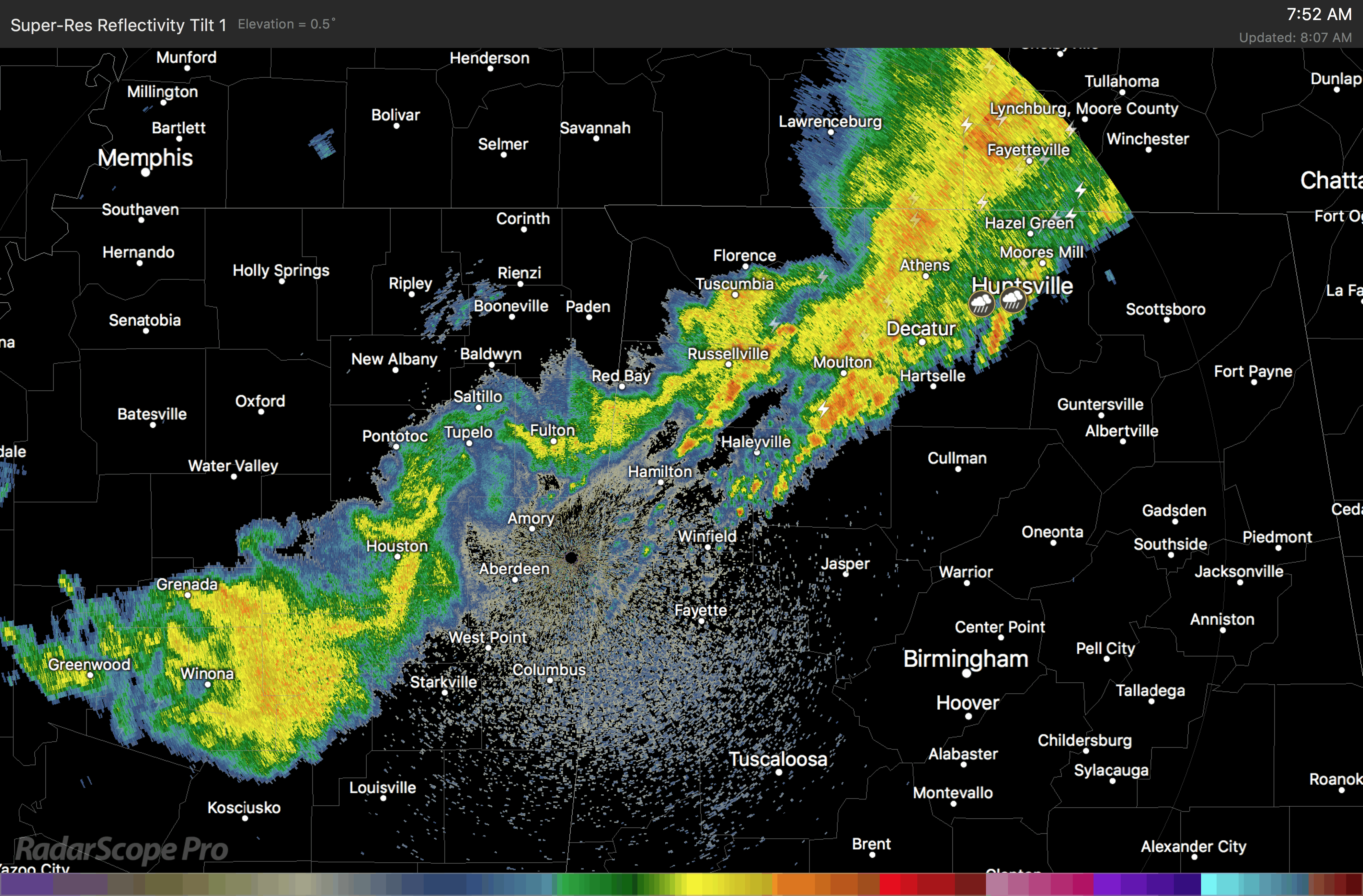
The line of showers and storms that had its origins across Oklahoma and Texas late yesterday afternoon is now into Northwest Alabama this morning.
at 7:40, decaying showers and storms with light to moderate rain cover parts of Lamar, Marion, Winston, Franklin, Lawrence, Limestone, Morgan, Lauderdale and Colbert Counties extending into Madison County.
The heaviest concentration of lightning is over Franklin County, over Lawrence County and over Madison and Jackson Counties.
Movement of the showers/storms is east at about 50 mph while the entire line is sinking southward slowly. It will affect parts of Fayette, Walker, Cullman, southern Blount and northern Jefferson Counties over the next 90 minutes, perhaps reaching as far south as I-20.
Of concern for Tuscaloosa and Birmingham is the decaying rain mass that is back near Winona, Mississippi, north of Jackson. It should continue to slowly diminish, and could bring showers to West Alabama’s Lamar, Fayette, Pickens and Tuscaloosa Counties around 11 a.m. to noon. It should stay north of Tuscaloosa and the Stadium for the A-Day game pregame activities, but we can’t rule out a shower.
There could also be a shower at Barber around noon if this area of showers hangs on. But it should be light.
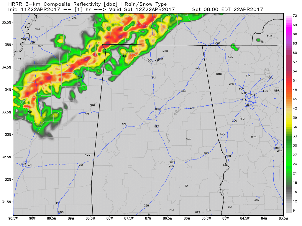
The latest run of the HRRR shows redevelopment of showers around 2 p.m. or so over West Alabama, meaning there could be a shower during the A-Day game and perhaps a shower or storm out at Barber around 4-5 p.m. Keep the rain gear handy just in case.
Meanwhile, the main development ahead of the cold front should start happening by 2-3 p.m. over Northwest Alabama around Lawrence County with more storms firing over Marion, Lamar, Winston and Walker Counties by 3-5 p.m.
The HRRR is slower with the evening activity, keeping it to the northwest of Lamar, Marion, Winston, Fayette, Walker and Cullman Counties through 11 p.m. before slowly diminishing as it drops into the I-59 corridor.
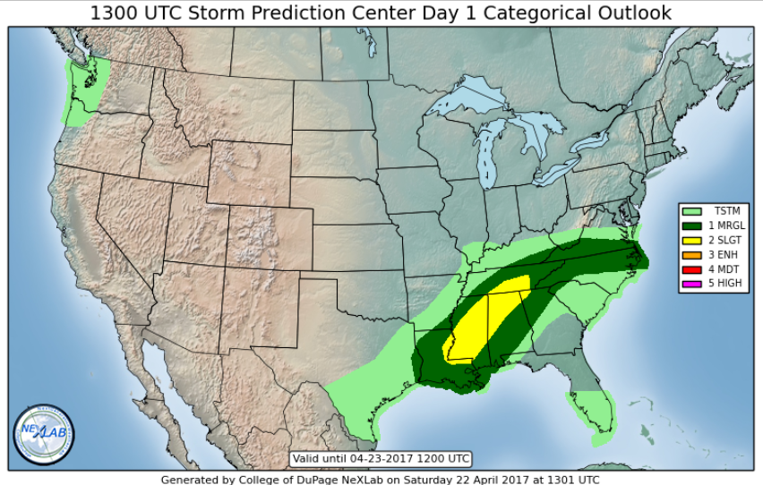
The updated risk from SPC came out at 8 a.m. and it still looks basically unchanged. Here is the latest:
We will be watching.
Category: ALL POSTS, Severe Weather
About the Author (Author Profile)
Bill Murray is the President of The Weather Factory. He is the site's official weather historian and a weekend forecaster. He also anchors the site's severe weather coverage. Bill Murray is the proud holder of National Weather Association Digital Seal #0001 @wxhistorianSubscribe
If you enjoyed this article, subscribe to receive more just like it.


