

All’s Quiet at Noon; Assessing the Severe Weather Situation
Here is a little back of the envelope figuring about today’s severe weather potential. We always like to show our work here at the blog.
WEATHER FEATURES
…Stationary front near the northwest corner of Alabama
…Weak surface low east of Texarkana
…Northwest Alabama is favorable position for upward motion with relation to the 300 millibar jet
…850 millibar (5,000′) jet over Louisiana and Mississippi
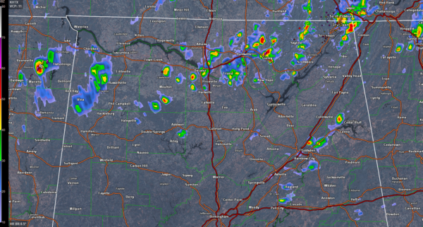
RADAR
Few showers over western Tennessee, northern Mississippi and eastern Arkansas as well as northeastern Louisiana. The line of showers that will eventually move into Alabama late this afternoon and this evening is visible now from Monroe LA to Clarksdale MS to Memphis. This bears out what the WRF has been predicting for this afternoon’s convective evolution.
SATELLITE
The new GOES-16 data is not operational, but it is incredible!

Some things to note:
…Dense fog/stratus over South Alabama this morning thinned with heating into stratocumulus that are evolving into cumulus clouds now
…Some low clouds and high cirrus left over from the morning convection to the west are moving across Central and North Alabama.
…Skies are now mostly sunny west of I-65, which is allowing the temperature to heat up.
…More cumulus clouds are filling in over West Alabama now where the heating is going on.
…Temperatures are up to 75F at Birmingham and Tuscaloosa and 78F at Demopolis
EVOLUTION/PARAMETERS
18z (1 pm)
…All quiet with just a few light showers possible over western sections
…CAPE values below 1,000 joules
…Bulk shear beginning to ramp up over West Alabama
21z (4 pm)
…Scattered showers and storms over Northwest Alabama, from Lamar and Marion Counties up into Colbert Counties
…Isolated showers/storms further south into Tuscaloosa and Greene Counties
…CAPE values approaching 1,500-2,000 joules over western counties.
…Bulk shear increasing
00z (7 pm)
…Strong to severe storms from Decatur down through Cullman and Blount Counties
…More strong to severe storms from Walker down into Tuscaloosa and Sumter Counties.
…Instability values decreasing, still around 1,000-1,500 joules
…0-3 km helicity values running around 250 m2/s2, so storms will still be organized
03z (10 pm)
…Strong storms just south of I-59
…750-1,250 joules of CAPE
…Decreasing shear
…Storms should be weakening
SEVERE THREAT
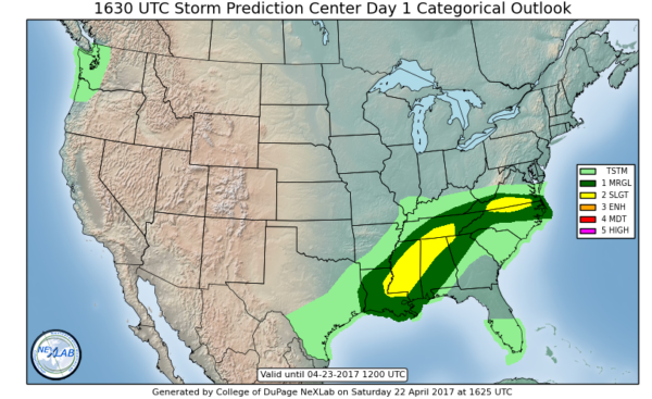
Expect severe storms north and west of I-59, perhaps as early as 4 p.m. over Northwest Alabama. Damaging winds and hail will be the main threats. The tornado threat is low. There is a 2% chance of a tornado within 25 miles of locations in the slight risk area from the SPC.
Category: ALL POSTS, Severe Weather
About the Author (Author Profile)
Bill Murray is the President of The Weather Factory. He is the site's official weather historian and a weekend forecaster. He also anchors the site's severe weather coverage. Bill Murray is the proud holder of National Weather Association Digital Seal #0001 @wxhistorianSubscribe
If you enjoyed this article, subscribe to receive more just like it.


