

A 1:15 p.m. Look at the Alabama Weather Situation
The SPC just issued a Mesoscale Discussion for much of Mississippi, Northwest Alabama and southern Tennessee. They are considering a watch for those areas.
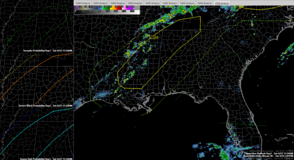
Here are the SPC risks. The categorical risk is in the large panel. The left panels include the tornado risk, the damaging wind risk and the severe hail risk.
Storms are beginning to form over the Mississippi Delta. One strong storm is already showing up near Greenville, MS.
The cap is basically gone over Mississippi and Alabama, and instability values are running 1,000-1,500 joules over our state. They are even higher over Mississippi.
Bulk shear is over 40 knots over Northeast Mississippi, southern Tennessee and Northwest Alabama. These shear values are sufficient for organized storms. Supercell storms will be possible, forming over Mississippi and moving into Northwest and West Central Alabama.
There is a tornado risk with any stronger storms, especially over Central Mississippi. The threat is non-zero, although low, into the northwestern quarter of Alabama.
The NWS Birmingham has noted the presence of a boundary over Central Alabama from this morning’s storms over North Alabama. It is located just south of I-20. This could be a focus that helps storms intensify later this afternoon and evening.
Storms will continue to intensify over Mississippi and push eastward into Alabama this afternoon. Damaging winds and hail will be the main threat, but an isolated tornado or two is not out of the question.
Category: ALL POSTS, Severe Weather
About the Author (Author Profile)
Bill Murray is the President of The Weather Factory. He is the site's official weather historian and a weekend forecaster. He also anchors the site's severe weather coverage. Bill Murray is the proud holder of National Weather Association Digital Seal #0001 @wxhistorianSubscribe
If you enjoyed this article, subscribe to receive more just like it.


