

Update on the Alabama Weather Situation at 4:30 p.m.

A wave of thunderstorms is spreading across eastern Mississippi and northwestern Alabama at this hour.
The storms are generally discrete, which creates the potential for them to be supercells.
Storms over Franklin County are the most intense right now, and a severe thunderstorm warning is in effect for Franklin and Lawrence Counties.
The storms should be into Marion and Winston counties between now and 5 p.m.
Storms over Lamar and Fayette counties are increasing in intensity and will move into Walker County soon.
Some of the most dangerous storms in Mississippi are over Scott, Leake and Neshoba Counties between Carthage and Philadelphia. These will impact Sumter and Greene Counties before 6 p.m.
The storms should be into Tuscaloosa Counties by 6:30 p.m. They should reach the Birmingham Metro and Gadsden by 7 p.m. They will be into Anniston by 8 p.m.
The best instability is over Northwest Alabama, where CAPE values are over 1,500 joules/kg. Instability values over 1,000 joules extend down to Clanton.
The best bulk shear is over the Tennessee Valley, where values are over 40 knots. 35 knot values extend down to I-59, which is supportive of supercell storms.
There is just not much 0-1 km storm relative helicity, so tornadoes are not out of the question but unlikely. The main threats will be damaging winds and hail.
The best jet dynamics have lifted off to the northeast for sure, which is a good sign. But there is a nice 500 mb wind max rotating through the base of the trough over northern Arkansas which could help offset that. A weak surface low is over Northwest Alabama, which may have helped that Franklin County storm. That low will track east across the Tennessee Valley this evening.
Here is the SPC slight risk area, where the greatest threat of severe weather is through this evening.
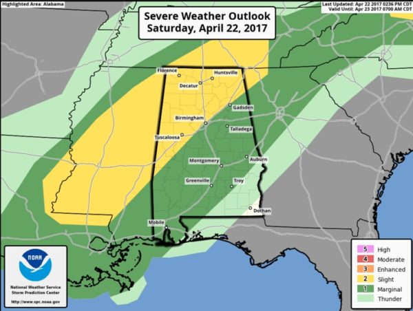
A marginal risk, meaning isolated severe storms covers much of the rest of the state.
Category: Alabama's Weather, ALL POSTS
About the Author (Author Profile)
Bill Murray is the President of The Weather Factory. He is the site's official weather historian and a weekend forecaster. He also anchors the site's severe weather coverage. Bill Murray is the proud holder of National Weather Association Digital Seal #0001 @wxhistorianSubscribe
If you enjoyed this article, subscribe to receive more just like it.


