

7:30 p.m. Update on the Alabama Weather Situation
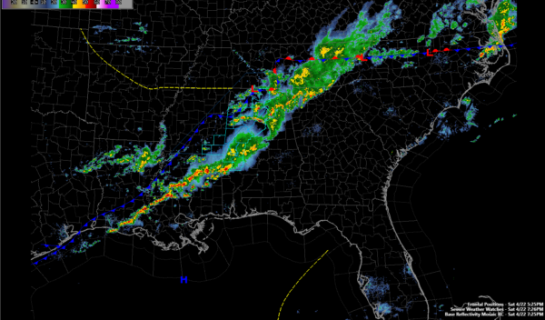
The showers and storms are beginning to slowly weaken as we lose the heating of the day and instabilities decrease. A large area of showers and some thunderstorms continues generally in the I-59 Corridor, extending back through parts of Northwest Alabama.
The strongest storms at this hour are in Walker County, moving into southern Cullman and Blount counties, and over northeastern Blount County, moving toward the Gadsden area.
Further south, decent storms are over Hale and Marion Counties moving toward southern Chilton County.
The stronger storms will have gusty winds, heavy rain and deadly lightning.
There could be some small hail in the eastern Walker County storm.
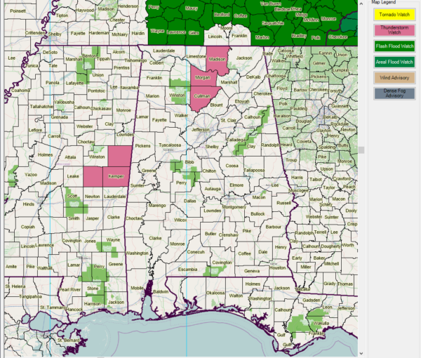
The NWS Birmingham just cleared all their counties from the watch. The NWS Huntsville continues the watch for Cullman, Morgan and Madison Counties until 10 p.m
REST OF THE EVENING
Low pressure is nearing Huntsville just after 7 p.m. A cold front is into the Northwest corner of Alabama. Showers and some storms will continue to form and push through areas generally along and north of I-20 through midnight.
SUNDAY MORNING
Additional showers will spread across the area during the early morning hours on Sunday. Rainfall amounts will be generally light but coverage will be fairly widespread. Indictions are the rain could continue into the afternoon hours It will be significantly cooler, with highs struggling to make the middle 60s.
Category: Alabama's Weather, ALL POSTS
About the Author (Author Profile)
Bill Murray is the President of The Weather Factory. He is the site's official weather historian and a weekend forecaster. He also anchors the site's severe weather coverage. Bill Murray is the proud holder of National Weather Association Digital Seal #0001 @wxhistorianSubscribe
If you enjoyed this article, subscribe to receive more just like it.


