

Storms Return To Alabama Very Early Thursday
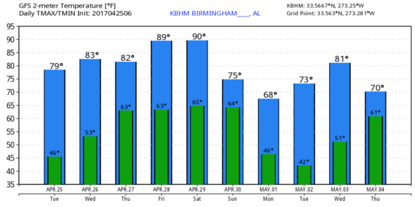
BEAUTIFUL SPRING DAY: With a sunny sky, temperatures are generally in the 74-77 degree range across North/Central Alabama this afternoon with low humidity levels. Tonight will be fair and pleasant with a low in the 55-60 degree range.
Tomorrow in Alabama will be warm and dry with ample sunshine, but to the west severe storms will likely develop by afternoon across much of Arkansas and adjacent states. These storms will move into our state after midnight tomorrow night.
STORMS VERY EARLY THURSDAY MORNING: SPC has far West Alabama in a “marginal risk” of severe storms for the hours prior to 7am Thursday, and then the rest of the state in a “marginal risk” after 7am Thursday…
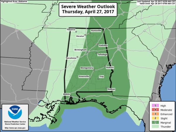
TIMING: The main window for storms will come from 2:00 a.m. until 10:00 a.m. Thursday; a line of storms will move from west to east across the state.
THREATS: Strong gusty winds and small hail will be the primary threats; the tornado risk is low. Not zero, but low.
RAIN: Rain amounts of around 1/2 inch are likely; no flooding is expected.
The sky becomes partly sunny Thursday afternoon as drier air returns to the state.
FRIDAY/SATURDAY: These two days will be very warm with a partly sunny sky; we project highs in the 85 to 90 degree range. We will mention the risk of isolated afternoon and evening storms both days because of high instability values, but most communities will be dry.
SUNDAY: Another strong spring storm system will bring the chance of strong to severe thunderstorms to Alabama Sunday afternoon into Sunday night; it is simply too early to determine the magnitude of the threat and the specific modes of severe weather. At the moment it looks like main window for these storms will come from 2:00 p.m. Sunday until 2:00 a.m. Monday.
NEXT WEEK: The sky becomes partly to mostly sunny Monday, and the day will be cooler with a high closer to 70. Tuesday looks cool and dry; a decent chance we reach the 40s early Tuesday morning… next chance of showers and storms will come toward the end of the week on Thursday or Friday. See the Weather Xtreme video for maps, graphics, and more details.
Click here to see the Beach Forecast Center page. Save Up To 25% on Spring Break Beach Vacations on the Alabama Gulf Coast with Brett/Robinson! The Beach Forecast is partially underwritten by the support of Brett/Robinson Vacation Rentals in Gulf Shores and Orange Beach. Click here to see Brett/Robinson’s best beach offers now!
WEATHER BRAINS: Don’t forget you can listen to our weekly 90 minute netcast anytime on the web, or on iTunes. This is the show all about weather featuring many familiar voices, including our meteorologists here at ABC 33/40.
CONNECT: You can find me on all of the major social networks…
Facebook
Twitter
Google Plus
Instagram
Pinterest
Snapchat: spannwx
I had a great time today at Honda Manufacturing of Alabama (HMA) as they rolled out the 2018 Odyssey… and also seeing the third graders at Calera Intermediate School. Be looking for those third graders on the Pepsi KIDCAM today at 5:00 on ABC 33/40 News! The next Weather Xtreme video will be posted here by 7:00 a.m. tomorrow…
Category: Alabama's Weather, ALL POSTS, Weather Xtreme Videos
About the Author (Author Profile)
James Spann is one of the most recognized and trusted television meteorologists in the industry. He holds the AMS CCM designation and television seals from the AMS and NWA. He is a past winner of the Broadcast Meteorologist of the Year from both professional organizations.Subscribe
If you enjoyed this article, subscribe to receive more just like it.


