

Severe Weather Threat Starting To End For Southeastern Parts of Central Alabama

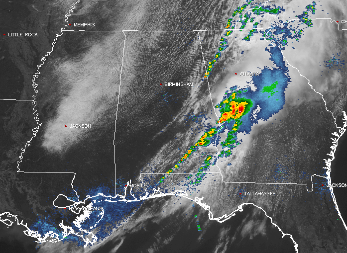
RADAR CHECK
Other than a few showers pushing into Georgia in Cleburne County, all of the shower and thunderstorm activity is currently located in the extreme southeastern part of Central Alabama. There is a slight risk for severe storms for the southeastern part of Central Alabama, but that risk will quickly fade to nothing after the line moves through. Gusty winds continue to be the main threat, but as we’ve seen throughout the late morning and during the noon hour, spin-up tornadoes are possible. Main threat area at this point is located east of a line from Ladonia (Russell Co) to Midway (Bullock Co) to Brundidge (Pike Co).
DAMAGE REPORTS
Good news is that the damage reports are very light… but we did have some trees and power lines downed in Montgomery County from a possible tornado, and some damage just a couple of miles northeast of Troy University in Pike County from another possible tornado.
FOR THE REST OF CENTRAL ALABAMA
A cold front is making its way through the state at the moment, and has pushed east of the I-65 corridor. Much of the area are under mostly clear to partly cloudy skies, with dry conditions west of the line of storms. Temperatures are currently running in the upper 60s in the northwestern parts of the area, with upper 70s to lower 80s in the southeast, and mostly mid 70s in the middle.
REMAINDER OF TODAY
Once the rest of the storms push out of the state and into Georgia, skies will begin to clear out and drier air will move in across Central Alabama. Afternoon highs will be in the mid 70s to the lower 80s across the area. Skies will continue the process of clearing out, and comfortable temperatures can be expected for tonight. Overnight lows will be in the upper 50s to the upper 60s across Central Alabama.
FRIDAY’S WEATHER
An almost summer-like pattern makes an appearance for the last day of the work week… Skies will be partly sunny throughout the day, and with the heating of the day, we could see a few isolated showers and storms develop during the afternoon and evening hours. While most locations in the area will stay dry, the odds of any one spot receiving rain will be around 1 in 8. Afternoon highs will be in the mid to upper 80s, and it is possible that a few locations may touch 90 degrees. Any shower or storm activity should dissipate for the evening hours, and it will be quite nice out on the town. Skies will be partly cloudy, and overnight lows will be in the mid to upper 60s… almost like a summer’s night.
If you would like to see what the weather holds for Ft. Morgan over to Panama City Beach, click here to see the Beach Forecast Center page. Save Up To 25% on Spring Break Beach Vacations on the Alabama Gulf Coast with Brett/Robinson! The Beach Forecast is partially underwritten by the support of Brett/Robinson Vacation Rentals in Gulf Shores and Orange Beach. Click here to see Brett/Robinson’s best beach offers now!
Category: Alabama's Weather, ALL POSTS
About the Author (Author Profile)
Scott Martin is an operational meteorologist, professional graphic artist, musician, husband, and father. Not only is Scott a member of the National Weather Association, but he is also the Central Alabama Chapter of the NWA president. Scott is also the co-founder of Racecast Weather, which provides forecasts for many racing series across the USA. He also supplies forecasts for the BassMaster Elite Series events including the BassMaster Classic.Subscribe
If you enjoyed this article, subscribe to receive more just like it.


